dendrite
-
Posts
75,076 -
Joined
Content Type
Profiles
Blogs
Forums
American Weather
Media Demo
Store
Gallery
Everything posted by dendrite
-
 All time all time there today
 -
00z euro was really hot up here. 12z gfs goes from 24C to 0C up near CAR. Could be a couple chilly nights for the rad pits.
-
Probably COC this time of year unless it gets more south for self destruction.

-
Let’s keep fixing problems by treating the symptoms and not the cause https://www.newscientist.com/article/2533348-seeding-clouds-with-seawater-could-prevent-a-super-el-nino/
-
Would love a week of rain.
-
June is a convenient cutoff considering May 2025 was 8.05”. But I get it, I want more rain too. PVD Historical Averages and monthly totals May 25 3.38” 8.05” +4.67” Jun 25 3.25” 1.15” -2.10” Jul 25 3.18” 5.08” +1.90” Aug 25 3.64” 2.76” -0.88” Sep 25 3.60” 6.24” +2.64” Oct 25 3.47” 4.80” +1.33” Nov 25 3.88” 2.56” -1.32” Dec 25 4.09 2.37” -1.72” Jan 26 3.82” 3.08” -0.74” Feb 26 3.32” 2.84” -0.48” Mar 26 4.16” 5.57” +1.41” Apr 26 3.86” 1.89” -1.97” May 26 3.38” 2.01” -1.37” Jun 26 3.25” 2.38” -0.87” Plus did they underreport liquid equiv in the big snowstorms this year? Spring has been dry, but where is the longterm 13” deficit?
-
Cold front of yore…err bore…coming through
-
Yeah I’m definitely curious. Watch us somehow end up with a 100” winter.
-
+4C or bust
-
Can’t believe this is happening again
-
I guess in their defense this is valid 8am Tuesday and there may not have been much river and stream response yet, but man...idk what they expect.
-
Yeah looks more dumb than malintent.
-
Heat indices in the MRV are modeled around 95° for a couple hours…it’s borderline. The difference I see in the criteria is GYX allows it for any amount of time (1+ day) whereas BOX requires at least 2 straight days of it.
-
It’s real https://www.fox8live.com/2026/06/27/heat-humidity-this-weekend-storms-return-mid-week/
-
Hoisting the Sultan Signal: Heavy Rain Event July 5-7
dendrite replied to WxWatcher007's topic in New England
Bummer. Not even a dent. -
I went to Pinkerton Fuck Londonderry
-
We’re not that bad, but the extended looks bleak…esp up here.
-
We need to get a good rain event in here ASAP
-
Hoisting the Sultan Signal: Heavy Rain Event July 5-7
dendrite replied to WxWatcher007's topic in New England
lol don’t ever change -
Hoisting the Sultan Signal: Heavy Rain Event July 5-7
dendrite replied to WxWatcher007's topic in New England
Another nice day today. Evening sun with low 70s. If it can't rain at least it isn't a ratter. But deep down I think y'all suck. -
Love to see it

-
@Typhoon Tip Will love this https://www.the-independent.com/life-style/cold-blob-atlantic-ocean-amoc-current-climate-change-b3009895.html
-
Hoisting the Sultan Signal: Heavy Rain Event July 5-7
dendrite replied to WxWatcher007's topic in New England
Potted plants dry out fast and I prefer to use collected rain water. Have you learned anything from Growing Wisdom? -
Hoisting the Sultan Signal: Heavy Rain Event July 5-7
dendrite replied to WxWatcher007's topic in New England
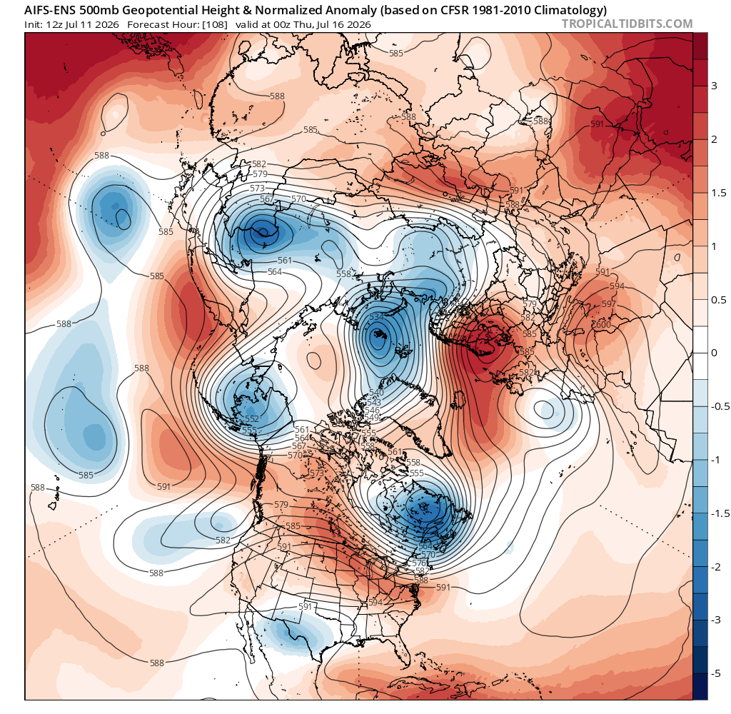
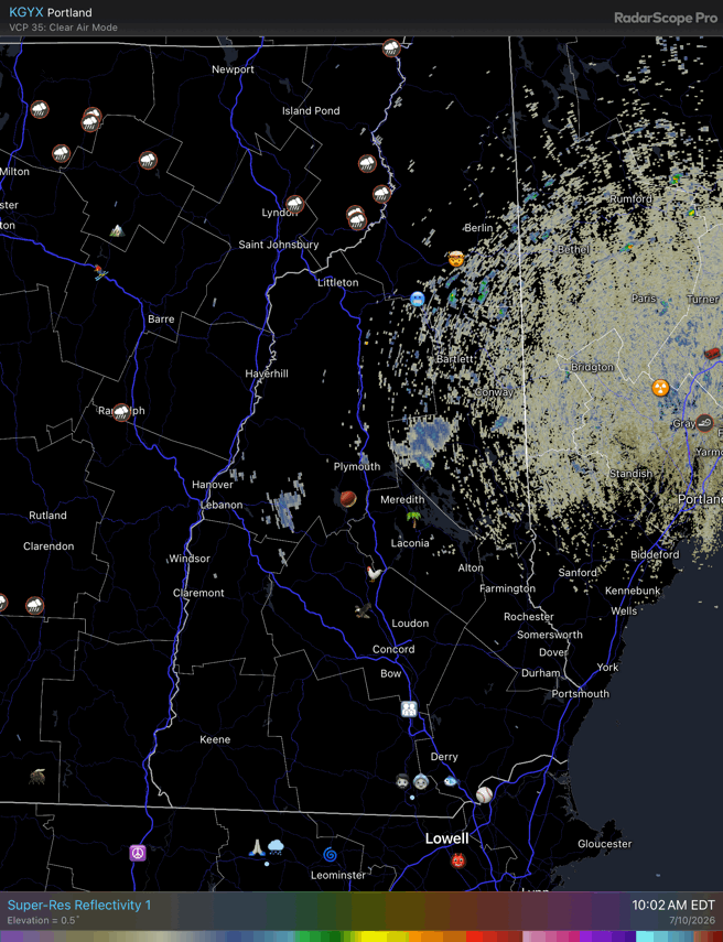
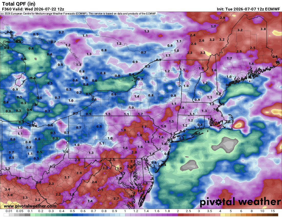
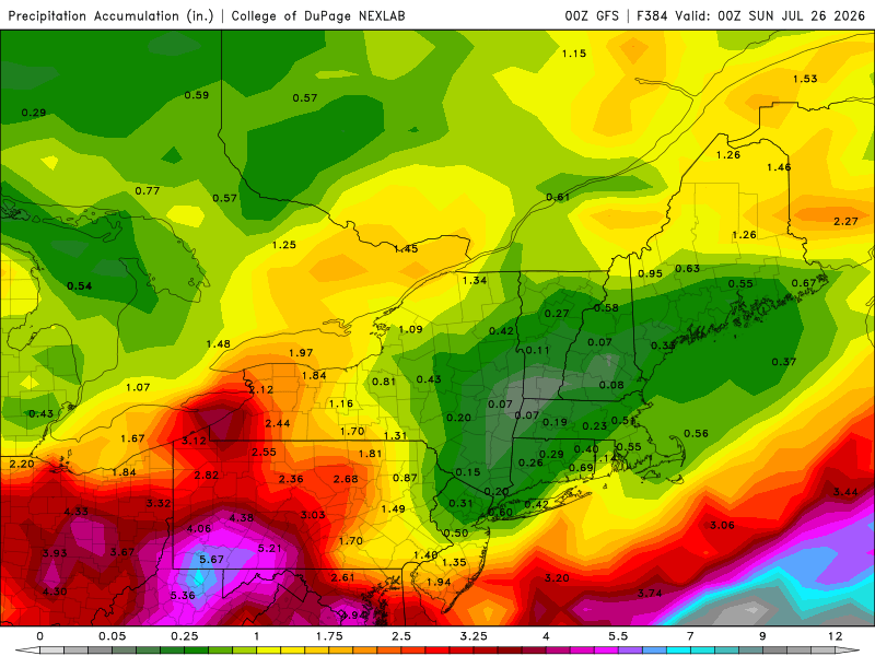
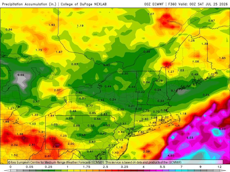
Starting to get dry up here. Wouldn’t care about missing this if there was something imminent in the next few days. Euro has the coop the driest in New England the next 15 days and even that’s overblown because some of that is today and we got nada.
-
Hoisting the Sultan Signal: Heavy Rain Event July 5-7
dendrite replied to WxWatcher007's topic in New England
Anyway I hope you get this man Hit me back, just to chat Truly yours, your biggest fan This is Stein