SACRUS
-
Posts
12,298 -
Joined
-
Last visited
Content Type
Profiles
Blogs
Forums
American Weather
Media Demo
Store
Gallery
Everything posted by SACRUS
-
Warm look overall - storms should keep extreme heat at bay till the 12thhh
-
TX rains from Beryl nd its remnants. Continue look for EC rains from Florida styler storms
-
-
This month first 3 days opening very similar to near identical to the 2015 season with a -1 to -3 departure. The seasons looks to divert bit as we move into this warmer/humid period. That year had very hot second half.
-
77 / 67 and partly cloudy. Hazy, hot, humid, upper 80s to low 90s where the most sun stays/comes out. Scattered storms are stubborn to popup later this evening and pm, but should be scattered north and west. Overall think 85% of the area is rain free and get to enjoy the day. The Western Atlantic Ridge is ballooning and nosing in from the east, keeping the EC warm. Overall, warm - hot and humid on a S/SW flow with rain chances and heatwave potential through next weekend or mid month. Heat in the west ejects east with stronger heat potential in the second half of the month. Happy Fourth
-
Records: Highs: EWR: 105 (1966) NYC: 103 (1966) LGA: 107 (1966) JFK: 104 (1966) Lows: EWR: 57 (1953) NYC: 54 (19r53) LGA: 57 (1969) JFK: 56 (2001) Historical: 1873: A tornado in Hancock County, in far west central Illinois, destroyed several farms. From a distance, witnesses initially thought the tornado was smoke from a fire. A child was killed after being carried 500 yards; 10 other people were injured. 1966 - The northeastern U.S. was in the midst of a sweltering heat wave. The temperature at Philadelphia reached 104 degrees. Afternoon highs of 102 degrees at Hartford CT, 105 degrees at Allentown PA, and 107 degrees at LaGuardia Airport in New York City established all-time records for those two locations. (David Ludlum) (The Weather Channel) 1975: Up to 3 inches of rain caused flash flooding throughout Las Vegas, NV. The main damage occurred to vehicles at Caesars Palace with approximately 700 damaged or destroyed with several cars found miles away. North Las Vegas was hardest hit with $3.5 million in damage. Two people drowned in the flood waters. 1987 - Lightning struck and killed three men playing golf on a course near Kingsport TN. The three men had sought shelter from the rain under a tall tree on a small hill. Showers and thunderstorms produced heavy rain in New Jersey, with 5.2 inches reported at Trenton State College. (The National Weather Summary) 1988 - Thunderstorms around Fort Worth, TX, produced wind gusts to 76 mph at Burleson, along with two inches of rain in thirty minutes. The record low of 46 degrees at Youngstown OH was their sixth in a row. (The National Weather Summary)(Storm Data) 1989 - Showers and thunderstorms produced locally heavy rain in the eastern U.S. Bowling Green, KY, was soaked with 4.99 inches of rain during the morning hours, and up to ten inches of rain deluged Oconee County SC. The temperature at Alamosa, CO, soared to a record warm reading of 91 degrees, following a record low of 35 degrees the previous day. (The National Weather Summary) (Storm Data)
-
Highs: TTN: 86 New Brnswck: 85 PHL: 85 TEB: 84 LGA: 83 EWR: 83 NYC: 83 ACY: 82 BLM: 81 JFK: 80 ISP: 79
-
87 for a splendid early July summer high.
-
83 / 53 what a gorgeous day,
-
Storm timing on models cruel for 4th of Jul fireworks but suspect its more isolated/scattered (N+W)
-
Nudge that west and the focus of the rain would favor PA/HV also a cut off low meandering offshore a few days.
-
Storms firing - brunt of storms chances Fri - Sat , then again Tue As BW pointed out Florida style heat/humidity and popup soakers
-
76 / 63 partly cloudy. Warmer regime moving in with higher humidity creeping up. Mid / upper 80s in the warmer spots ad the ridge expands northeast. Overall warm / hot and humid with rain storms chances the next 7 - 10 days with a ridge into the SW - trough into the MW / and the Western Atlantic Ridge nosing higher heights along the east coast with a humid tropical flow. 7/3 - 7/11 : Warm-hot (at times) humid and rain / storm chances 7/12 and beyond : western / rockies ridge ejects pieces of stonger heat east.
-
Records: Highs: EWR: 102 (1966) NYC: 100 (1966) LGA: 101 (1966) JFK: 101 (1966) Lows: EWR: 56 (2001) NYC: 56 (2001) LGA: 58 (2001) JFK: 56 (2001) Historical: 1833 - An unusually large New England tornado, one half to three quarters of a mile wide, went from Salem Pond to Norton Pond, VT, and then into Canada. It prostrated nearly everything in its path. (The Weather Channel) 1833: The following is from the "History and Description of New England" published in 1860: "On the 2nd of July, 1833, this town (Holland, Vermont) was visited by a violent tornado, which commenced on Salem Pond in Salem, and passed over this place in a northeasterly direction. It was from half to three-quarters of a mile wide and prostrated and scattered nearly all the trees, fences, and buildings in its course. It crossed the outlet of Norton Pond and passed into Canada, and its path could be traced through the forests nearly to Connecticut River." 1843 - An alligator reportedly fell from the sky onto Anson Street in Charleston, SC, during a thunderstorm. (David Ludlum) 1987 - Thunderstorms in Colorado produced hail as large as golf balls northwest of Kiowa, which accumulated to a depth of twelve inches. Hail two and a half inches in diameter was reported at Black Forest. Hail damaged 900 acres of crops south of the town of Wiggins. (The National Weather Summary) (Storm Data) 1988 - Twenty-six cities in the eastern U.S. reported record low temperatures for the date. The morning low of 47 degrees at Roanoke, VA, broke the July record set the previous day. (The National Weather Summary) 1989 - Thunderstorms produced severe weather in the south central U.S., with 158 reports of large hail and damaging winds through the day. Evening thunderstorms in northeastern Texas produced softball size hail which caused more than five million dollars damage at Allen, and wind gusts to 90 mph at Dallas, which injured eight persons and caused seven million dollars damage. Winnfield LA reported 29.52 inches of rain in six days, for a total of 62.50 inches for the first six months of the year. Midland, TX, reported an all-time record high of 112 degrees. (Storm Data) (The National Weather Summary) 2001: In Michigan, frost and freezing temperatures were observed in some locations with Grant dropping to 29 degrees. Muskegon reported their coldest July temperature on record with 39 degrees. Other daily record lows included: Lansing: 38, Muskegon: 39, Flint: 40, Youngstown, Ohio: 40, and Grand Rapids, Michigan: 43 degrees.
-
Highs: NYC: 86 PHL: 86 New Brnswck: 85 PHL: 85 EWR: 85 TEB: 84 LGA: 83 ACY: 83 ISP: 82 JFK: 82 BLM: 81
-
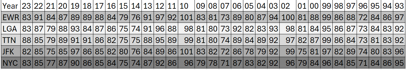
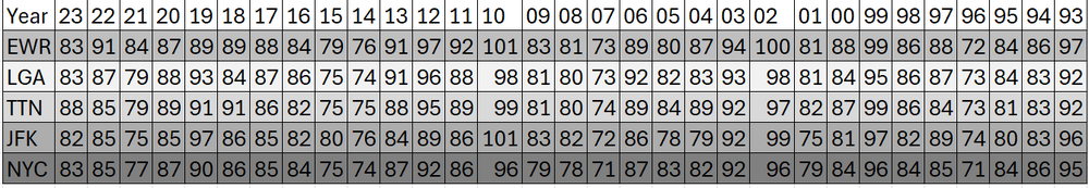
July 4th the past 30 years (highs)
-
Partly cloudy and warm upper 80s to 90s, by the evening a piece of energy is triggering storms to the west and north, perhaps some scttered / isolated showers into the evening - not ideal but looks overall 85%- 90% like a great fourth. Good luck and enjoy.
-
Sharp contrast between the 23 / 24 Junes. Keep the SI stats coming - perhaps a happy median from the NYC / EWR readings.
-
Ridge west/ trugh MW, ridging into the east coast. Warm/humid with more chances for rain/ wetter
-
74 / 54 sunny and another gem on tap. Low - Mid 80s, warmer spits to the upper 80s. A bit warmer tomorrow s ridge builds in mid / upper 80s, perhaps a stray 90 in the warmer spots. $th of July mainly dry but some scattered storms later in the evening. Ridge west, trough into the MW, and Western Atlantic Ridge keeping heights elevated along the East coast with a humid southerly/SW flow. Overall warm - hot with chances for storms and increased rainfall. Cut off low under the Atlantics ridge meander offshore. Hotter day Sun (7/7). Clouds will limit heat when storms fire but chances of near/low 90s in the period. 7/1 - 7/3 : Dry, warm near normal 7/4 - 7/11: Warm - hot, humid - storms almost daily 7/12 - beyond : Overall warm, could see piece of western heat eject east
-
Records: Highs: EWR: 100 (1963) NYC: 100 (1901) LGA: 97 (2018) JFK: 102 (1963) Lows: EWR: 52 (1943) NYC: 52 (1943) LGA: 56 (1988) JFK: 56 (1988) Historical: 1792 - A tremendous storm (a tornado or hurricane) hit Philadelphia and New York City. Many young people were drowned while out boating on that Sunday. (David Ludlum) 1911 - The high of just 79 degrees at Phoenix AZ was their coolest daily maximum of record for the month of July. The normal daily high for July 1st is 105 degrees. (The Weather Channel) 1979 - It snowed almost half a foot (5.8 inches) at Stampede Pass WA, a July record. (The Weather Channel) 1987 - Lake Charles LA was drenched with a month's worth of rain during the early morning. More than five inches of rain soaked the city, including 2.68 inches in one hour. A thunderstorm in the southern Yakima Valley of Washington State produced high winds which downed trees up to six feet in diameter. (Storm Data) (The National Weather Summary) 1988 - Twenty-six cities in the north central and northeastern U.S. reported record low temperatures for the date. Lows of 48 degrees at Providence RI, 48 degrees at Roanoke VA, 49 degrees at Stratford CT, and 48 degrees at Wilmington, DE, were records for the month of July. Boston MA equalled their record for July with a low of 50 degrees. Five inches of snow whitened Mount Washington NH. (The National Weather Summary) 1989 - Showers and thunderstorms associated with the low pressure system which was once Tropical Storm Allison continued to drench parts of Mississippi, Louisiana and eastern Texas. Late night thunderstorms produced 12.58 inches of rain at Biloxi, MS, in six hours, and 10.73 inches at Gulfport MS. Flooding in Mississippi over the first six days of the month caused 55 million dollars damage. (The National Weather Summary) (Storm Data) 2002: San Antonio, Texas recorded 9.52 inches of rain on this day to set a new record for its greatest rainfall for the entire month of July.
-
Highs: EWR: 84 ACY: 84 New Brnswck: 82 JFK: 82 PHL: 82 BLM: 81 ISP: 81 NYC: 81 TTN: 81 TEB: 80 LGA: 79
-
Think the 10th was a 0 departure they may lump in as a (-) I have 4 (missed the -1 on the 12th.)
-
Only 3 below average daily avg at EWR in June, the rest at or above normal
-
Great stats, Don thanks for sharing. 8 90 degree days?