

CaryWx
-
Posts
2,765 -
Joined
-
Last visited
Content Type
Profiles
Blogs
Forums
American Weather
Media Demo
Store
Gallery
Everything posted by CaryWx
-
zr
-
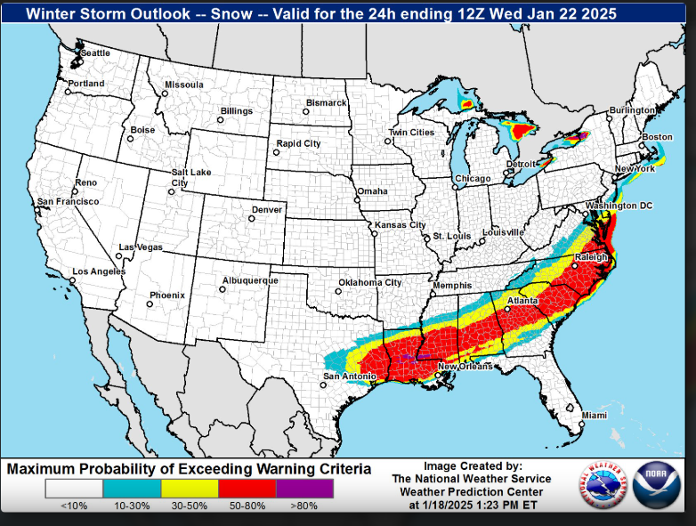
If this verifies RAH will need to add Lee & Harnett counties as WSW
-
Not sure it will be 5" snow in Triangle if your ne-->sw line includes that
-
Is that assuming 10:1 ratios only?
-
For NC folks west of I95 it all depends on where the FGEN sets up for best precip rates
-
WRAL playing this down on the evening report
-
yes
-
For NC nice jump NW
-
Glad to see you get a WSW. Sure it wasn't even in your thinking a couple weeks ago.
-
A word to the wise--Don't take snow/ice totals too seriously at 84hrs on the NAM
-
From the real mccoys
-
50-75miles northwest of memorable heavy action at 102hrs? I'll take that spot
-
Heck, I'm right in river city and I wouldn't start a thread this evening
-
Nobody wants to start the thread. On either board. It's a jinx move. There simply isn't enough definitive information yet.
-
Even KC (RAL) mentioned the nw trend. Not typically seen until ~48hrs prior. We've all seen it happen in the Triangle. Usually to our demise but this time?---this time we could score decently if things go right
-
still it needs to align with a major partner to be believed more readily
-
up and vanished like a **** in the wind
-
crushed and splattered like a cockroach in the garage
-
Sounds like we need to see what the next 0z eps has for best look forward at 5days on the 21st/22nd storm
-
Need some consistent runs on the euro too
-
GEFS is not so bad. Let's give the operational a few runs to see where it goes
-
Don't see an eps 'mean' like that too often
-
My iPhone apple weather app says snow next Tues. That's all the confidence I need.
-
Yeah, some of the ensembles have the storm just further back west
-
Can you post a pic of this in NC? The ice accrual I mean


