CaryWx
-
Posts
2,765 -
Joined
-
Last visited
Content Type
Profiles
Blogs
Forums
American Weather
Media Demo
Store
Gallery
Everything posted by CaryWx
-
 I meant twitterverse
 -
Any mets on social media chiming in about lower rates in the Triangle or honking be patient.
-
Thing is will these heavier rates nw of Columbia hit or miss the Triangle to the east.
-
What's your location?
-
This. Plus the heavy stuff is progged for 10pm-2am
-
I think it's projected to end in the Triangle by 3am. Still that's a good 7hrs of moderate+ snows
-
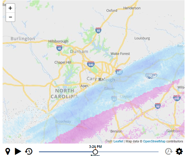
I would have to say returns look heavier for those in Garner attm
-
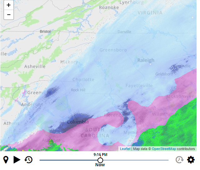
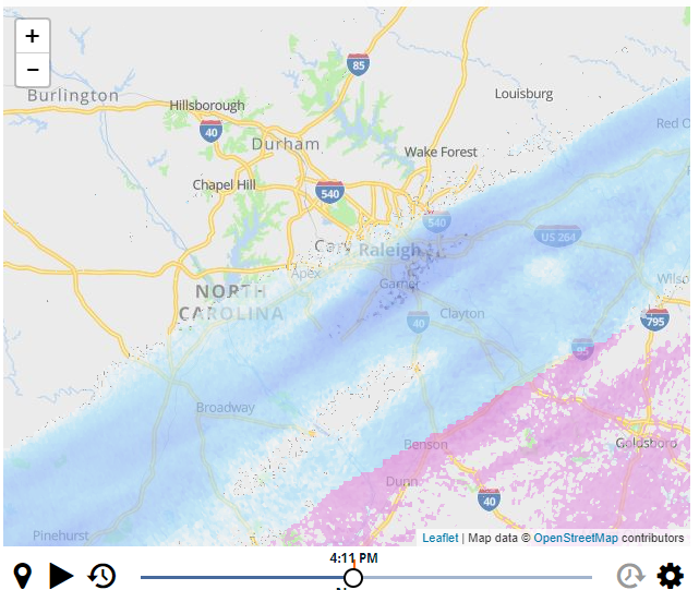
Another snapshot of icontrol radar for Raleigh area. Curtesy WRAL
-
Very light flurries here in southeast Cary 4:05pm. 5mins behind schedule.
-
I know WRAL's icontrol is not all that but this is why I am not seeing flurries yet nor some others in Raleigh.
-
Ok, I will check again and squint hard...
-
Still nothing in Cary. 27.1 F on my home station
-
January 20-22 “bring the mojo” winter storm threat
CaryWx replied to lilj4425's topic in Southeastern States
Sounds like RAH set a new threshold--again. Probably last one though. I am just about square on that line between Wadesboro to Roanoke Rapides. Uncanny. -
January 20-22 “bring the mojo” winter storm threat
CaryWx replied to lilj4425's topic in Southeastern States
See folks, it pays to be on a first name basis with the NWS offices. j/k Thanks for the heads up Matt. -
January 20-22 “bring the mojo” winter storm threat
CaryWx replied to lilj4425's topic in Southeastern States
Thanks Gun. Yep, sure missed that. Not down at 850mb. I need to pay attention more. -
January 20-22 “bring the mojo” winter storm threat
CaryWx replied to lilj4425's topic in Southeastern States
Is that the ULL southwest of Ashville?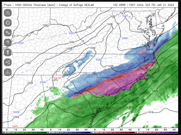
-
January 20-22 “bring the mojo” winter storm threat
CaryWx replied to lilj4425's topic in Southeastern States
I saw that too on the gfs. Question is where exactly will that set up and how large and long of duration will it be.. Progged just northwest of the airport attm. Could be further northwest or further southeast. Going to have to wait until nowcast time I'm afraid -
January 20-22 “bring the mojo” winter storm threat
CaryWx replied to lilj4425's topic in Southeastern States
I know RAH uses the objective criteria for guidance on issuing county notices but wonder since Canes Hockey is a 'Go' this evening would they take subjective criteria into consideration as well. In other words, better to have Wake under a WSW just so they can cya with that event full of traffic. Sort of a---well folks, we had issued a WSW prior to the game -
January 20-22 “bring the mojo” winter storm threat
CaryWx replied to lilj4425's topic in Southeastern States
4 counties in SC have WSWs now. -
January 20-22 “bring the mojo” winter storm threat
CaryWx replied to lilj4425's topic in Southeastern States
I'd like to see this happen and not be overdone, but we'll know in about 18hrs or so.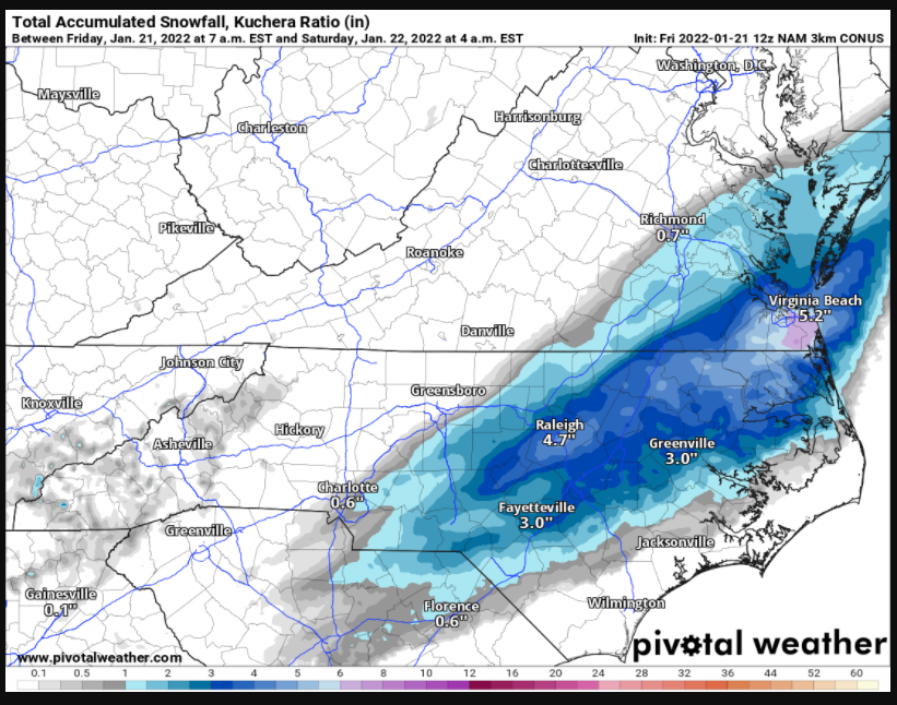
-
January 20-22 “bring the mojo” winter storm threat
CaryWx replied to lilj4425's topic in Southeastern States
You're now practically in the sweet spot 21hrs out Brick. -
January 20-22 “bring the mojo” winter storm threat
CaryWx replied to lilj4425's topic in Southeastern States
I hear you but typically your lead off comments 9x out of 10 would be attributing low totals to ip/zr. Now we contend with air that is too dry and cold aloft. We indeed live on a cutting edge weather gradient -
January 20-22 “bring the mojo” winter storm threat
CaryWx replied to lilj4425's topic in Southeastern States
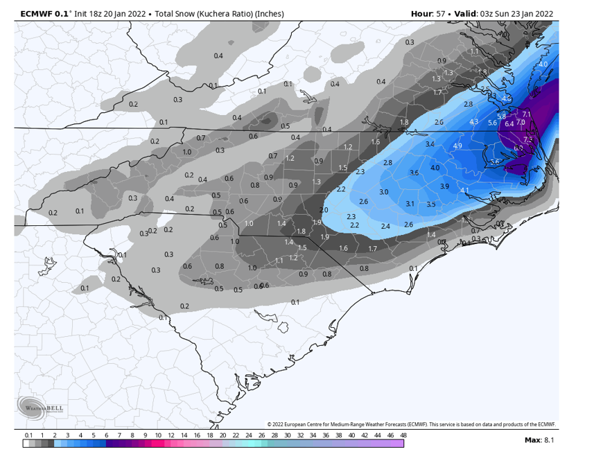
From RAH as of 5am A wave of surface low pressure will then move offshore along the stalled Arctic front later Friday into Friday night, with a mid- level shortwave trough moving across NC. This will give the first significant accumulating snow of the season to many parts of central NC. Snow will spread from SE to NW from the late afternoon into the overnight hours, heaviest and most widespread from about 00z to 06z and exiting to the east by about 09z (possibly ending as freezing drizzle) as dry air quickly moves in. Essentially all models, including the GFS and ECMWF as well as short-term high-res models like the NAM, RAP, and HRRR, have trended farther west with the low and its associated precipitation shield during the last 24 hours. Thus raised POPs to likely to categorical across most of the region except the far NW, and increased forecast snowfall totals slightly. Generally expect 3-4 inches east of I-95, 2-3 inches from the US-1 corridor to I-95, and a dusting to 2 inches NW of there. It should be stressed that there is still some uncertainty on these totals, in particular on how far west the snow shield will make it, as it will be fighting dry air in the NW. The GFS continues to insist on a stronger jet streak and associated upper divergence, and thus brings the snow much farther west than other models do. Forecast amounts may have to be raised a bit further if models continue their westward trend, though the 06z NAM and GFS look very similar to their 00z runs. Thus for now continue the Winter Storm Warnings and Winter Weather Advisories as is, and will reassess the need to change anything after the 12z guidance comes in. One thing we are confident about is that the column will be sufficiently cold for snow nearly everywhere. The one exception is the far SE (mainly southern Sampson County) where models show still having enough warm air aloft to stay sleet and freezing rain for much of the event. Thus a tenth to a quarter inch of freezing rain is still forecast in southern parts of Sampson county. Lows will be in the mid-teens to lower-20s on Friday night with continued north winds around the deepening low off the coast. This will bring wind chills down to the single digits to lower-teens. -
January 20-22 “bring the mojo” winter storm threat
CaryWx replied to lilj4425's topic in Southeastern States
Yeah after the overnight models thought Wake country would be upgraded to a WSW but looks like RAH left their advisories as is. -
January 20-22 “bring the mojo” winter storm threat
CaryWx replied to lilj4425's topic in Southeastern States
kuchera