NorthShoreWx
-
Posts
4,761 -
Joined
-
Last visited
Content Type
Profiles
Blogs
Forums
American Weather
Media Demo
Store
Gallery
Everything posted by NorthShoreWx
-
As luck would have it, the records I have for New Haven begin on 5/1/1969. Here are snowfall reports from some other coops in CT for 2/9-10/1969: Stamford 21.5" Bridgeport 18" Danbury 18" Woodbury 17" Hartford 16" Shuttle Meadow Reservoir 18" Middletown 22" Colchester 19" There was less in eastern CT: Groton only reported 5" but a few miles north Norwich had 12"
-
Snow isn't frequent in Ireland. Bathed in warm air from the north Atlantic, they get their coldest weather with east or even southeast winds off of the continent, which has been the case the past several days. Most of their limited snowfall is OES, although parts may get significant synoptic scale snowfalls Thursday (Tersday) - Friday. I found this guy's discussion fascinating, although he does seem to be hugging the Euro
-
Significant snow - ice or rain Feb 10-12
NorthShoreWx replied to wdrag's topic in New York City Metro
Don't know, but there were unofficial reports in old newspapers of -20F or a little lower from several towns in Suffolk County in February 1934. -
OBs and nowcast TUESDAY 2A-6P Feb 9, 2021
NorthShoreWx replied to wdrag's topic in New York City Metro
Short version: Complete non-event here. Longer version: It drizzled a little yesterday max t 33. Also a tiny amount of freezing drizzle later in the afternoon. It was very light...not a particularly noticeable mist. Nothing in the bucket. It's almost fair to say the day was dry. If only it had been colder we might have seen some fairy dust if looking really closely. Most interesting wx of the day was temperature rising from 12.9 at 4am to 33.4 at 10:30am then slowly falling after that.- 82 replies
-
- 1
-

-
- snow
- freezing rain
- (and 1 more)
-
Significant snow - ice or rain Feb 10-12
NorthShoreWx replied to wdrag's topic in New York City Metro
It would have to be within 12 hours. 3" in 24 hours would not get any advisories. -
Significant snow - ice or rain Feb 10-12
NorthShoreWx replied to wdrag's topic in New York City Metro
January 1961 lowest temp recorded on LI at Upton -23F. Crazy stuff. -
OBs and nowcast TUESDAY 2A-6P Feb 9, 2021
NorthShoreWx replied to wdrag's topic in New York City Metro
The precip band from the south appears to be falling as wet snow over the south fork (12:20pm). Pretty sure that was modeled as rain. https://www.hamptons.com/Montauk-Cam#.YCLGauBOl-E- 82 replies
-
- 1
-
-
- snow
- freezing rain
- (and 1 more)
-
Obs and nowcast Super Bowl Sunday 4A-6P Feb 7, 2021
NorthShoreWx replied to wdrag's topic in New York City Metro
The biggest reason for variation in how fast snowmelts around here is nighttime temperatures. If one place radiates below freezing and another stays above freezing all night, the difference is substantial. In the morning when snow that has been softening all night in the city starts melting even faster, the frozen snow in colder areas takes a while to start melting even as the temperatures go above freezing. It is a very large difference when the UHI holds court in NYC. -
2-7-21 Sunday 8-12 hour nor'easter snowstorm roughly 5A-5P
NorthShoreWx replied to wdrag's topic in New York City Metro
Yeah, superbowl Sunday was crazy warm, then Monday morning we had 9" of heavy wet snow. -
2-7-21 Sunday 8-12 hour nor'easter snowstorm roughly 5A-5P
NorthShoreWx replied to wdrag's topic in New York City Metro
Except it wasn't 60 degrees yesterday. -
Obs and nowcast Super Bowl Sunday 4A-6P Feb 7, 2021
NorthShoreWx replied to wdrag's topic in New York City Metro
8" here as of 5pm. Still snowing...maybe another tenth or two. I'll remeasure in a bit. Back up to 17" on the stake, but it's tilting slightly for some reason -
Obs and nowcast Super Bowl Sunday 4A-6P Feb 7, 2021
NorthShoreWx replied to wdrag's topic in New York City Metro
Nice color! ESB sounds good. I'm suddenly feeling a little parched. -
Obs and nowcast Super Bowl Sunday 4A-6P Feb 7, 2021
NorthShoreWx replied to wdrag's topic in New York City Metro
Satisfying my curiosity, I looked elswhere. The northeast extension of the band we have been enjoyiing on LI is absolutley crushing downtown Boston. Past 5" here and approaching 6" (estimated) Smithtown -
Obs and nowcast Super Bowl Sunday 4A-6P Feb 7, 2021
NorthShoreWx replied to wdrag's topic in New York City Metro
Looks very good for >6". This is 2"/hr stuff at the moment. Slight mitigating factor is that the wind has been quite gusty at times here. The mainland peeps have been talking about how calm its been with the falling snow. -
Obs and nowcast Super Bowl Sunday 4A-6P Feb 7, 2021
NorthShoreWx replied to wdrag's topic in New York City Metro
S+ poundage now. 30 degrees. I haven't measured yet, but started the morning with 8" at the stake and it flirting with a foot now. That's good for a rough idea only. Smithtown, LI -
Obs and nowcast Super Bowl Sunday 4A-6P Feb 7, 2021
NorthShoreWx replied to wdrag's topic in New York City Metro
Finally moderate to heavy snow here and the temperature which had dropped from 37.7 at 9am to hovering a couple of tenths above freezing most of the morning has dropped to 30.9 in the past 15 minutes. The parts of the blacktop that were still melting are now snow covered. Probably about 1.5" total so far. The wind has also been getting pretty gusty. Smithtown, LI -
The top of the bluffs on the east end of Sunken Meadow look like that in places. The bluff top trail is alternating between blown bare and deep drifts. Some of the drifts are covered in a layer of blown sand that looks just like that. I did a 6 mile hike around various areas of the park this evening, half of it in the dark with a headlamp. The headlamp part was the best. There was no one else out, the wind had died and the snow was freezing up and getting quite supportive: https://www.facebook.com/MyMountainFamily/posts/2377036792420117
-
2-7-21 Sunday 8-12 hour nor'easter snowstorm roughly 5A-5P
NorthShoreWx replied to wdrag's topic in New York City Metro
Ah. LB will do fine. A little light rain at the start won't eat much of the qpf. -
2-7-21 Sunday 8-12 hour nor'easter snowstorm roughly 5A-5P
NorthShoreWx replied to wdrag's topic in New York City Metro
When did you return to LB? -
2-7-21 Sunday 8-12 hour nor'easter snowstorm roughly 5A-5P
NorthShoreWx replied to wdrag's topic in New York City Metro
That is wording carried forward from 4am. The 1:33pm AFD updated the near term but not the rest. -
Obs and nowcast Friday morning 3A-Noon Feb 5, 2021
NorthShoreWx replied to wdrag's topic in New York City Metro
Light rainfall here Friday morning totalled 0.04" If no one saw it, did it really happen?- 21 replies
-
- 1
-

-
- snow
- freezing rain
- (and 2 more)
-
2-7-21 Sunday 8-12 hour nor'easter snowstorm roughly 5A-5P
NorthShoreWx replied to wdrag's topic in New York City Metro
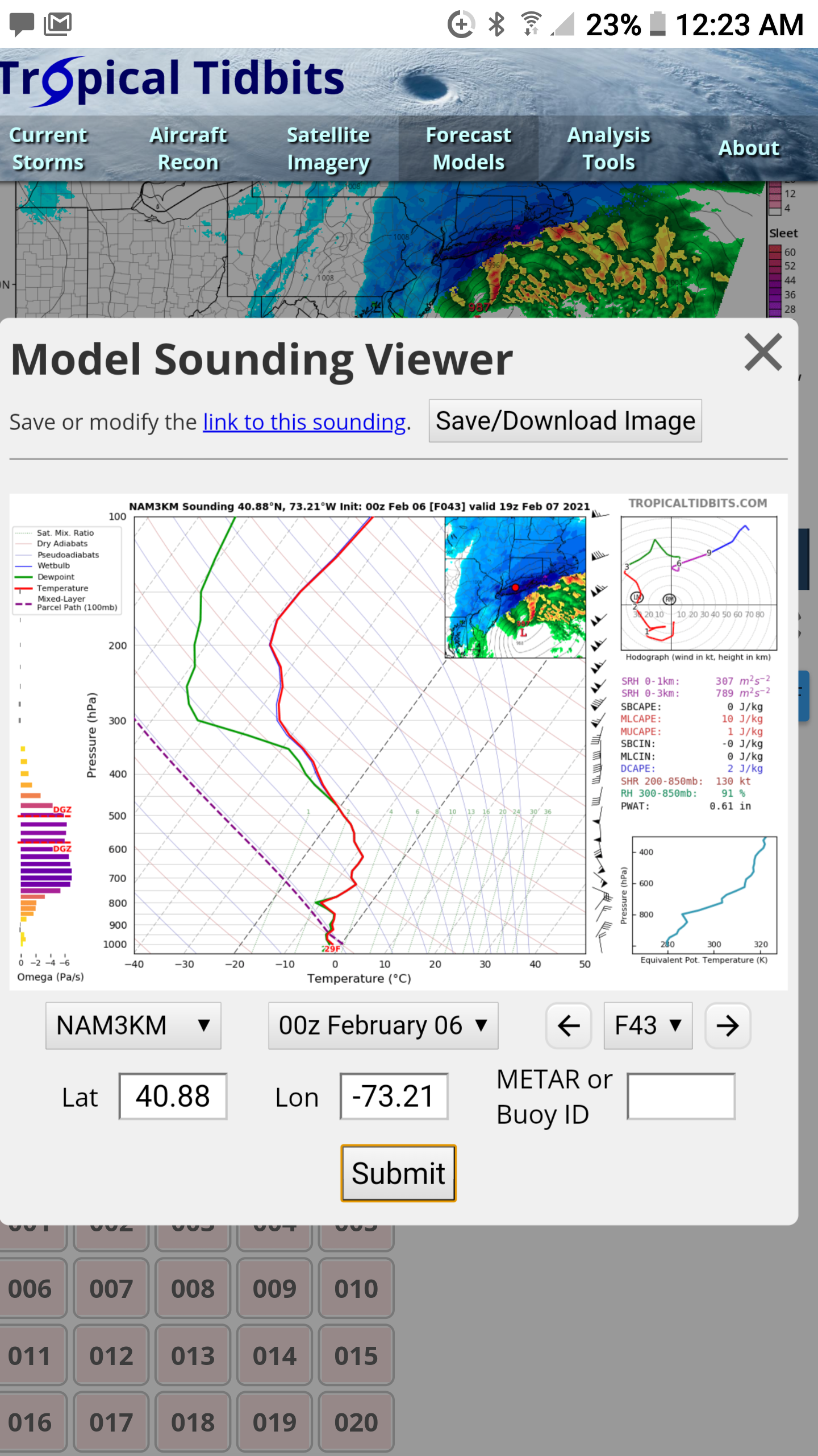
Surprised there wasn't more buzz from LI'ers about the 0z NAM. Maybe it's wrong, but that 5" of snow in an hour at 19Z on Sunday would be memorable.
-
2-7-21 Sunday 8-12 hour nor'easter snowstorm roughly 5A-5P
NorthShoreWx replied to wdrag's topic in New York City Metro
They're both still alive. -
Thanks. That works for me. Every storm is different, but we often did a little better than Mineola, so 30" or more in Syosset in 1961 is definitely possible. Pretty sure that 1961 snow depth hasn't been matched since. 78 best efforts measurement (so much wind!) was 24" which was what was on the ground at the end of the storm. So that would have been our max snow depth that year. Wiping a board, that storm could have been 30" and NYC would easily have been over 20" possibly well over given that it snowed for 36 hours. That's the problem with comparing individual older storms with more recent. We're definitely getting more big storms, but the big ones aren't really bigger than the old time biggies.
-
A little too young. I never heard any mention of sleet in Syosset. It doesn't mean it didn't happen. Having grown up in that house, I'd estimate the snow depth could easily be 30". That drift in front of the bay window was about 6 feet.