wxmx
-
Posts
3,741 -
Joined
-
Last visited
Content Type
Profiles
Blogs
Forums
American Weather
Media Demo
Store
Gallery
Everything posted by wxmx
-
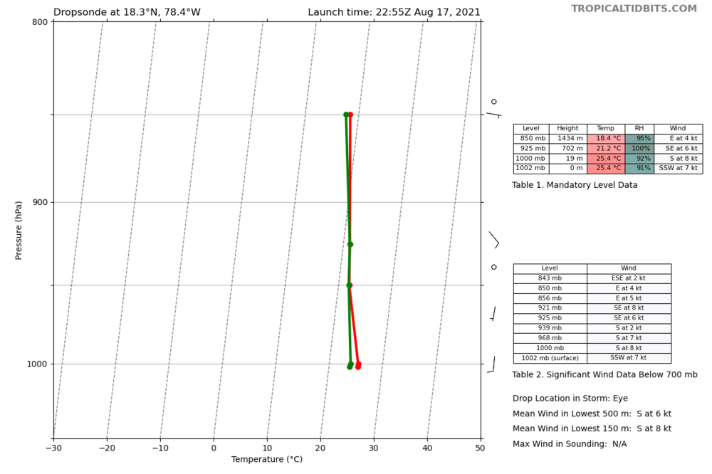
Recon supports an upgrade to at least 60 kts, with FL around 74kts and several SFMR obs 60-67 kts.
-
1002 according to dropsonde
-
Yes, it has evolved from a classic "9" low, to a more symmetric cyclone, with good outflow in the western semicircle. Most of the core is still over land, and although Jamaica is a bit rugged, the highest peaks are in the eastern portion of the island. It probably still has around 6 hours over land before exiting fully over water. Shear is low, less than 15 knots, and since structure seems to be improving, at least steady strengthening should be expected until landfall in the Yucatan. I don't discard RI, but we will have more info this evening.
-
Especially in the middle of August
-
It's even gaining some latitude in the short term, that enhances the probability of Puerto Cabezas/Bilwi being in the northern eyewall, plus the highest surge.
-
885mb 165 kts
-
That's because that awesome outflow channel is evacuating the upper levels of the cyclone nicely, forcing strong connection to popup over Gamma. The next 24 hours it'll see the strongest shear, relaxing a bit gradually afterwards
-
It's moving a bit faster than forecasted. About to get it's feet wet. I think it will get a bit farther north than the forecasted track before turning west, southwest
-
The only place in the GOM where where shear is forecasted to remain low (and there's little dry air) is the Bay of Campeche. There have been a few GFS runs showing a significant cyclone there (not the Euro), but most just shove it well SW, after the Yucatan, towards land, without much chances to develop.
-
Doing ok...yeah, I have little time nowadays, but Hannah, and now TD22 (and the likes) will always pull the weather weenie out of me
-
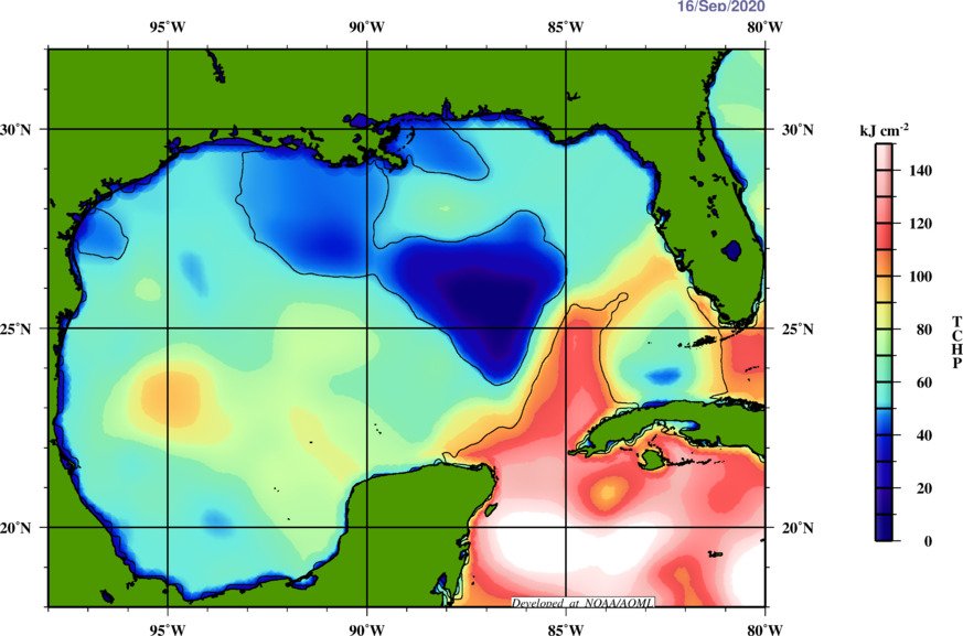
Warming up sea surface wouldn't take much time, and usually, more important than sun light is wind. Calm seas, with little churning can sensibly warm sea surface...and low clouds at night to trap some of the low level atmospheric heat would also help. But that would be at depths of no more than a few meters. The heat capacity of the area south of LA is pretty low right now, so I don't think it would recover much in that aspect. A smaller, faster moving system would resent this heat content loss less than a bigger, slower moving one.
-
Would be quite a feat, being inland ... but yeah, it looks like a bona fide TC around 22.2N
-
Texas/New Mexico/Louisiana/Mexico Obs And Discussion Thread Part 8
wxmx replied to wxmx's topic in Central/Western States
A couple of days ago a tornado hit the NE part of the metro area. It was a confirmed EF-2 twister. 3 people died, and there was significant damage. The affected area is more of an industrial zone. It was the first record of a direct hit of a tornado in Monterrey. There have been close calls before, but no direct hits.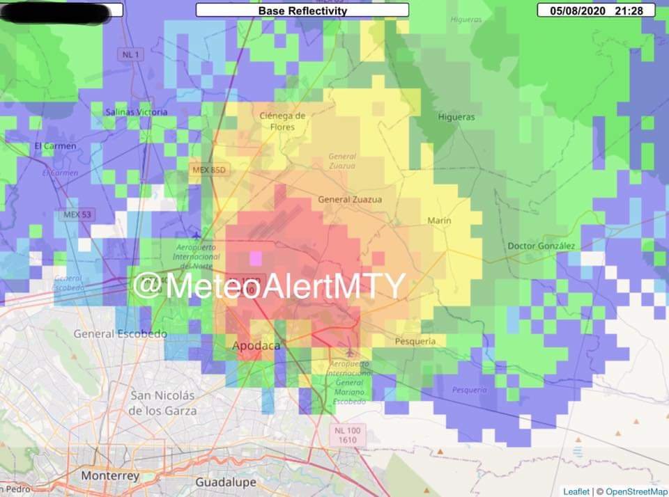
-
2019 Atlantic Hurricane Season
wxmx replied to AfewUniversesBelowNormal's topic in Tropical Headquarters
24 hours rainfall, as reported near the airport, 507mm (20 inches)... Slight rain at the moment, and not big accumulations are expected, although the next few 2-3 days we are still expecting precipitation. -
2019 Atlantic Hurricane Season
wxmx replied to AfewUniversesBelowNormal's topic in Tropical Headquarters
"Wimpy" Fernand has dumped 10" IMBY and counting. -
Texas/New Mexico/Louisiana/Mexico Obs And Discussion Thread Part 8
wxmx replied to wxmx's topic in Central/Western States
Around 14+ hours non stop rain around MBY today. I estimate around 6-7" have fell, and it's raining cats and dogs out there attm. -
Texas/New Mexico/Louisiana/Mexico Obs And Discussion Thread Part 8
wxmx replied to wxmx's topic in Central/Western States
A bit of hail in Guadalajara a couple of nights ago -
Texas/New Mexico/Louisiana/Mexico Obs And Discussion Thread Part 8
wxmx replied to wxmx's topic in Central/Western States
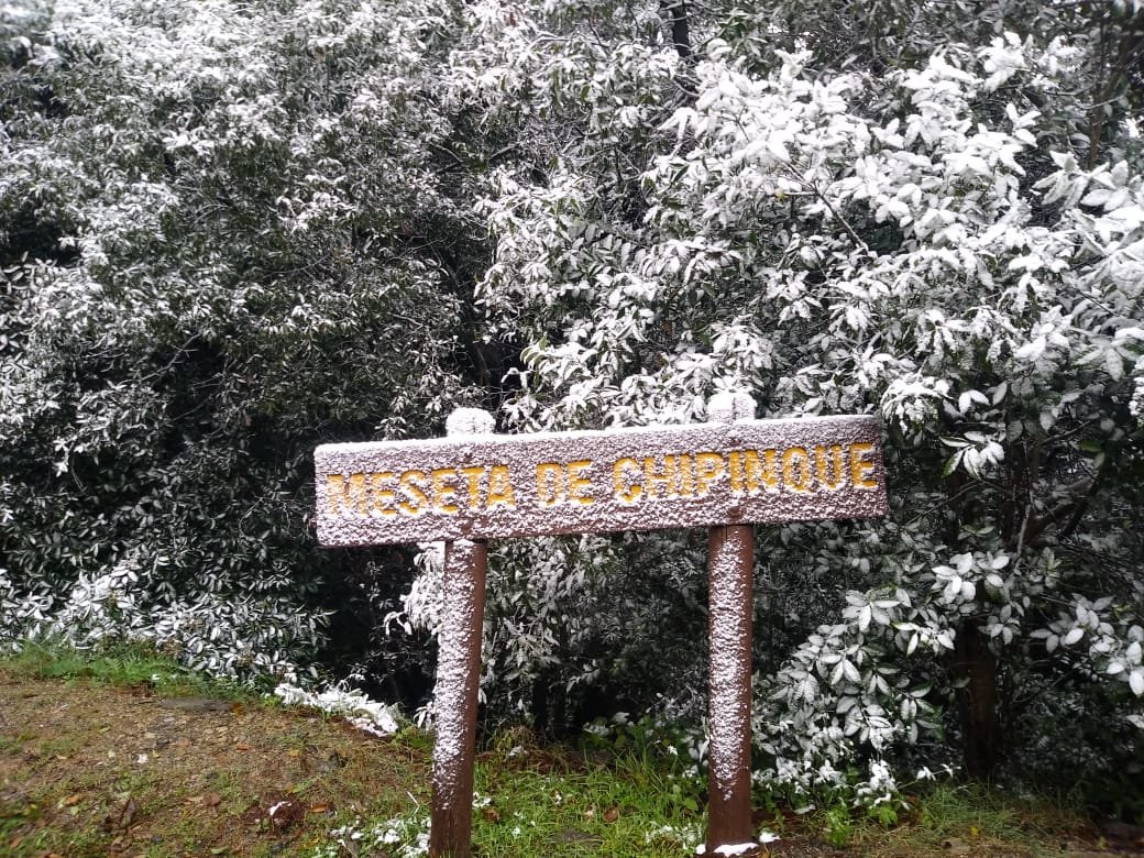
Just like in last November, and last winter as well, strato snow (low level cold dome, with overrunning warm, relatively moist air) was seen at around 1300m+ a couple of days ago. Pretty uncommon occurrences, that have become more frequent these last 2 winters. By Saturday we expect highs in the mid 90s. Not even Vivaldi executed his Four Seasons so fast.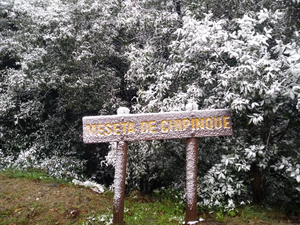

-
Texas/New Mexico/Louisiana/Mexico Obs And Discussion Thread Part 8
wxmx replied to wxmx's topic in Central/Western States
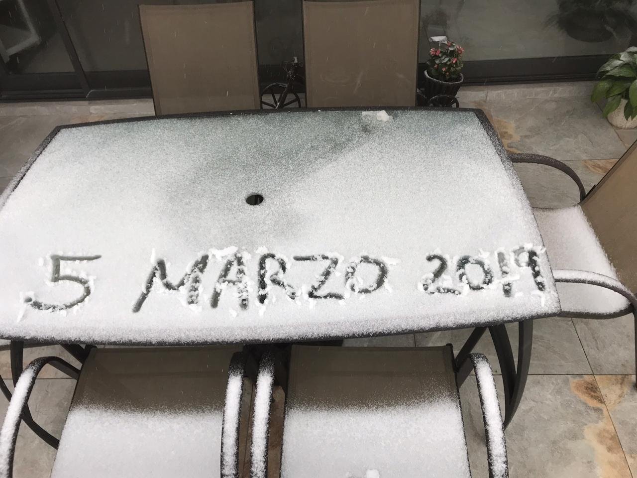
Last winter's pattern appears to be showing up again. It's veeery early for snow here, but models show that there's an outside chance, especially over high land. -
Texas/New Mexico/Louisiana/Mexico Obs And Discussion Thread Part 8
wxmx replied to wxmx's topic in Central/Western States
Looking at the MJO, the GEFS and EPS continue to show a very strong wave about to enter phase 7, but past day 7 significantly slowing and losing amplitude. The operational models aren't as aggressive with the wave plummeting, and that would be a better prospect for storminess overall. -
Texas/New Mexico/Louisiana/Mexico Obs And Discussion Thread Part 8
wxmx replied to wxmx's topic in Central/Western States
Yeah, fully agree with your assessment. Looks like constant cold seeping south, east of the Rockies, but dry overall, other than South TX, MX and the Gulf Coast, which could have drizzle and lows developing east of Brownsville. Unless we get that strong PV weaken, move south and elongate in a positive trough, lowering the heights in the SW, much more colder and wetter prospects look hard to obtain. -
Texas/New Mexico/Louisiana/Mexico Obs And Discussion Thread Part 8
wxmx replied to wxmx's topic in Central/Western States
Not necessarily...you can get a Baja low that doesn't dig that far into MX and some ridging near the SE coast. That could create a nice bowling ball low for N TX. Also, you can get a big low level high moving south the plains, with ridging in MX...that would be a good setup for overrunning events in N TX as well. What I'm trying to highlight is that there's a good chance that we'll get a very cold source in Canada and that eventually the cold dam will burst. Whatever happens next is up for grabs. -
Texas/New Mexico/Louisiana/Mexico Obs And Discussion Thread Part 8
wxmx replied to wxmx's topic in Central/Western States
A PV near the Hudson Bay is one of the elements present in a McFarland signature. A tightly wound vortex won't unload the cold into the lower latitudes, or it will in small doses, but a deep storm moving south from the upstream flow can relax the heights into the lower latitudes. That can happen if we get a strong west coast ridge, better if it connects to the EPO ridge (we have had a few this winter). It can lead to suppression (again, this winter), but a not so strong ridge (neutral PNA) can benefit the southern Plains with a storm. All this is speculative, and, as I said before, I think the models were too fast with the pattern change to colder, and as expected they have been delaying the cold dam burst past day 10. But a passage of a coherent MJO wave into phases 8-2 would activate the above mentioned storms, and relax the heights with high amplification. With a so cold and dense air mass, you don't even need that much amplification, and even can have overrunning events without a strong mid level storm present. The synoptic events to watch are 1. the migration of the Aleutian ridge to NE Siberia then progress east to Alaska, plus a strong vortex near the Hudson Bay...that's a recipe for very cold anomalies in Canada (very confident it will happen) and 2. a ridge building near the West coast, that allows amplification, and storms to ride south, downstream from said ridge and upstream from the Canadian vortex (much more iffy, especially considering it's in the long range). -
Texas/New Mexico/Louisiana/Mexico Obs And Discussion Thread Part 8
wxmx replied to wxmx's topic in Central/Western States
But the AO and EPO are forecasted to go negative