wxmx
-
Posts
3,741 -
Joined
-
Last visited
Content Type
Profiles
Blogs
Forums
American Weather
Media Demo
Store
Gallery
Everything posted by wxmx
-
Tropical Storm Alberto--Mexico Landfall at 50mph/993mb
wxmx replied to WxWatcher007's topic in Tropical Headquarters
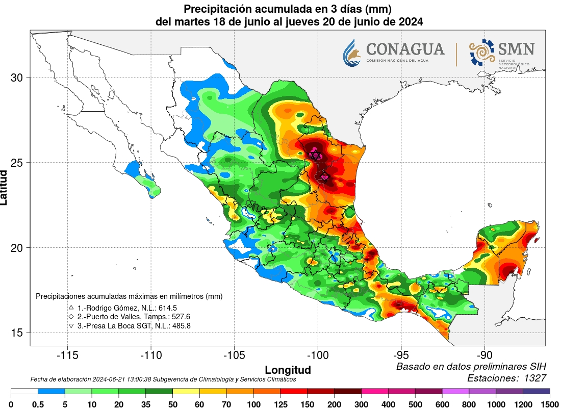
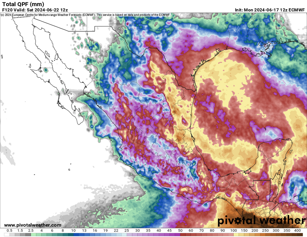
The highest reading is from a station in the Sierra, almost 25". Stations around the city vary from 11 to 18". With the highest amounts near the mountains. That's up to today 9am CDT. Today we still are having some rain, but not as heavy as yesterday. Interesting that the Tampico area has the lowest precipitation, being the landfall point
-
Tropical Storm Alberto--Mexico Landfall at 50mph/993mb
wxmx replied to WxWatcher007's topic in Tropical Headquarters
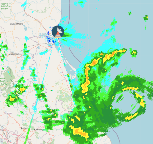
Around 7" have fallen around here (I have found no official reading yet). It's still raining hard, and a rain band is well aligned to train over the city...that plus the orographic effect, I expect 3 or 4 more inches of rain, at least. -
Tropical Storm Alberto--Mexico Landfall at 50mph/993mb
wxmx replied to WxWatcher007's topic in Tropical Headquarters
Convection is flaring near and on top of the center. It's not a big one, but maybe just enough to get this one baptized -
Tropical Storm Alberto--Mexico Landfall at 50mph/993mb
wxmx replied to WxWatcher007's topic in Tropical Headquarters
Thanks Jeb. It definitely sinks in when your city is specifically mentioned in a Discussion Advisory. -
Tropical Storm Alberto--Mexico Landfall at 50mph/993mb
wxmx replied to WxWatcher007's topic in Tropical Headquarters
This is a closed circulation now, symmetrical, better organized, but it needs more convection near the center. Pretty big circulation, covers the whole GOM west of 88W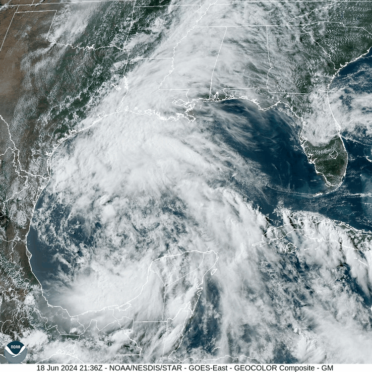
-
Tropical Storm Alberto--Mexico Landfall at 50mph/993mb
wxmx replied to WxWatcher007's topic in Tropical Headquarters
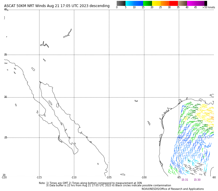
The sprawling nature of the cylcone will definitely hinder the development of something significant, but the fact that the eastern energy is taking control (you can see the smaller vorticity center west, near the Tamaulipas coast, caught in "orbit" of the stronger vorticity near the Yucatan) allows for much better mid/upper atmospheric conditions and more time over water to organize. It just needs more consistent convection near the eastern center to get a name. Also, the further east initial position will allow for more ridging to build in the SE US. I think this can get to a 45-55 kts TS, with a trending to faster organization/tightening just prior to landfall near Tampico (maybe a hair south of what the NHC is currently forecasting) -
Tropical Storm Alberto--Mexico Landfall at 50mph/993mb
wxmx replied to WxWatcher007's topic in Tropical Headquarters
Certainly looks like a multi-year drought buster, from famine to feast, weather here knows no middle ground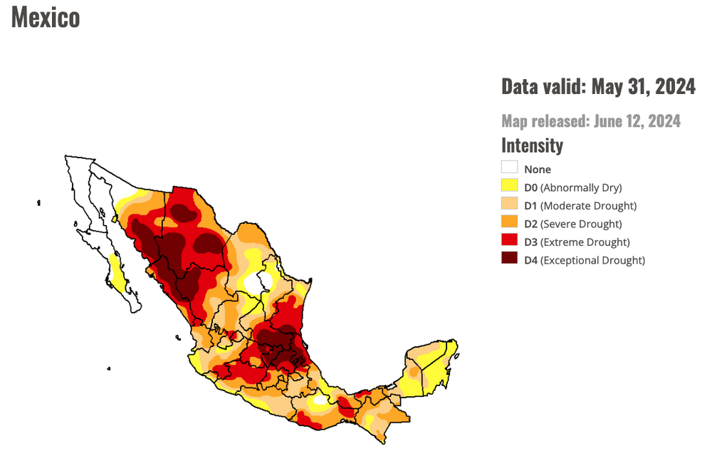
-
Looks like a well defined LLC
-
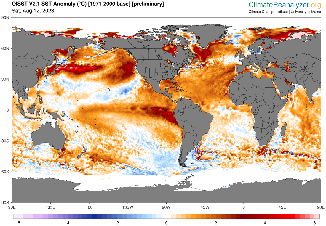
Report: Another Year of Record Heat for the Oceans
wxmx replied to donsutherland1's topic in Climate Change
El Niño & +AMO ... but the lack of significant below normal areas is quite something.
-
Report: Another Year of Record Heat for the Oceans
wxmx replied to donsutherland1's topic in Climate Change
Source
-
Looking at the models/ensembles, the stronger/earlier development, the farther right it goes, looks like a good example of beta drift.
-
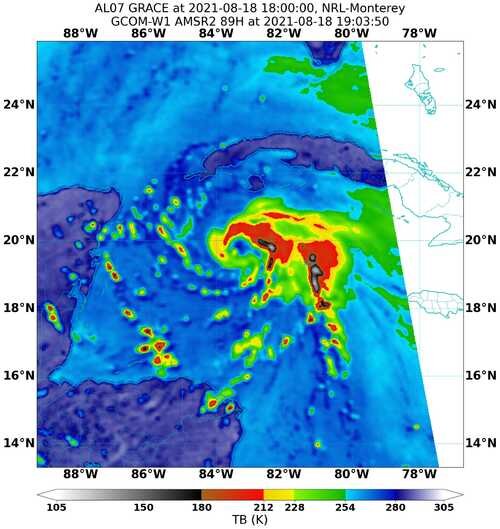
Officially a cat 2 - 85 kts hurricane, with 967mb central pressure.
-
968mb extrapolated, 85 kts SFMR. It will probably be upgraded to cat 2
-
Visible imagery. Sunset are the beer googles of hurricanes.
-
Hopefully before sunset. Would be a very photogenic image of Grace
-
Shear has abated some, to around 10-15 kts. Looks like it gained a bit of latitude during the convective explosion, but not much. Now looks like Tecolutla may be ground zero. If trends continue we can speculate on a major at landfall.
-
Diana 1990 and Gert 1993 are possible analogs to strength and landfall location. They both caused record flooding in the area.
-
Yeah, no cyclone is match to the Sierra Madre. The bigger and meaner, the more dramatic the fall. Only thing is all it's juice is squeezed out, causing mudslides and extensive flooding.
-
Yes, now I have this image in my mind

-
And right on cue. The last 12 hours up to landfall were the ones that we expected Grace would intensify more aggressively and we are near that threshold. We needed a hurricane that looked like one, and it's taking that look now.
-
Briefly yesterday https://www.nhc.noaa.gov/archive/2021/al07/al072021.discus.022.shtml?
-
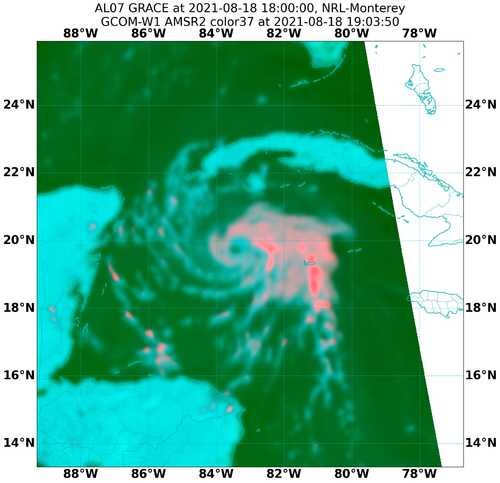
Three hours old, but that's a pretty good structure. If it can get steady < -70C cloud tops in the eyewall, it can RI.
-
990mb from dropsonde and 10kts wind. Slowly but steadily intensifying.
-
989mb extrapolated