wxmx
-
Posts
3,741 -
Joined
-
Last visited
Content Type
Profiles
Blogs
Forums
American Weather
Media Demo
Store
Gallery
Everything posted by wxmx
-
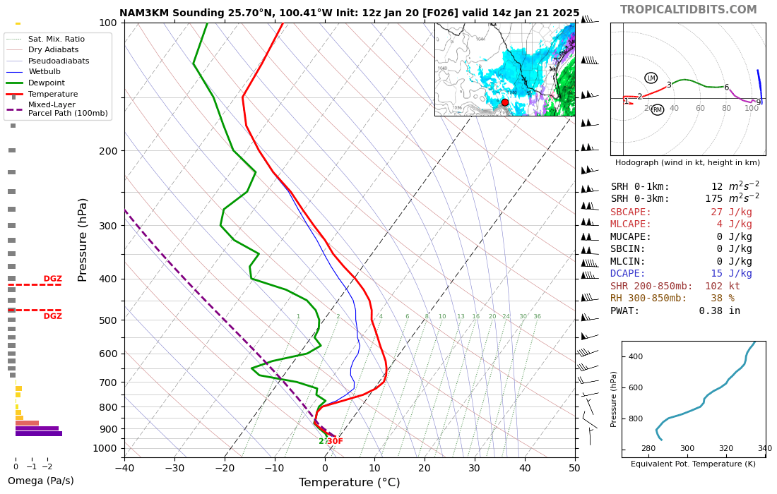
May be getting some light snow for several hours Tue morning here. No worries about warm nose above 800mb because snow growth is below that. Classic low level stratus with overrunning moist air thanks to Sierra Madre CAD. This usually produces drizzle, but since it will be below freezing for the whole shallow column, snow can occur. This is not common, but it happened in the aforementioned 2021 cold blast. Usually to get freezing temps here we get a full on artic dome, which lower the DPs drastically, inhibiting any precipitation. Surface temps may be a factor as well since they will be hovering around 32F. No accumulation is expected, other than on cold surfaces.
-
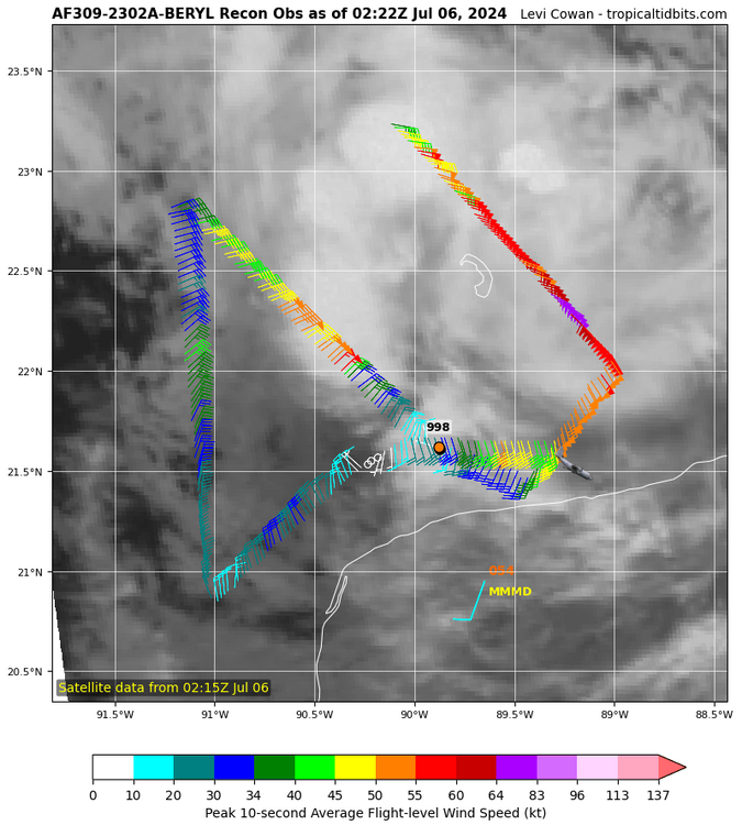
Recon says no major... Yet, but close
-
Looks like the other way around (EC-AIFS has always been in the GFS camp, BTW), 18zGFS has mostly conceded into a turn towards the SW into the BoC. It basically decouples it first, before the LLC turns to the SW. Euro weakens it, but not fully decouples. Now, looking at the current trends, I don't buy the GFS decapitating Rafael in 36 hours or so, as a matter of fact, we are probably looking at a bounce back to major status for the next advisory. If it can walk the fine line around the shear boundary, south of 25N, then intensity could be much higher than forecasted.
-
Shear is weakening, and Rafael is showing a more symmetrical/round shape on satellite, also an eye is clearing out. Latest recon confirms FL winds around 106kts, we'll see about central pressure, but I'm guessing a down trend will shortly begin, especially after dry air gets mixed out through the strong convection going on right now.
-
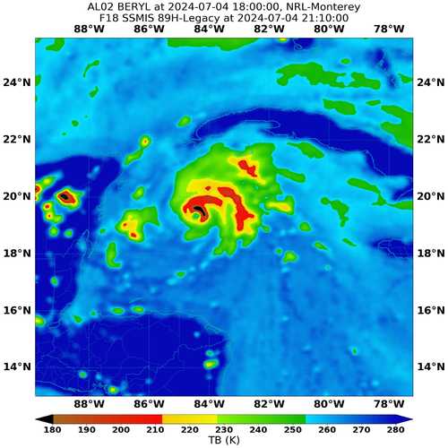
It looks like we are in the final legs of the ERC, with the old eyewall coalescing into the new one. Recon still shows a bit of a double wind maxima, but will probably disappear soon
-
Radar shows clear ERC going on now. It appears that it might be a matter of a few hours before the inner eyewall collapses. https://bmcnoldy.earth.miami.edu/tropics/rafael24/Rafael_5Nov24_Cayman.mp4
-
TCs west of 90W are a rare sight in November. If it keeps hurricane status, it would be a first.
-
I'll leave this out here and back away slowly...
-
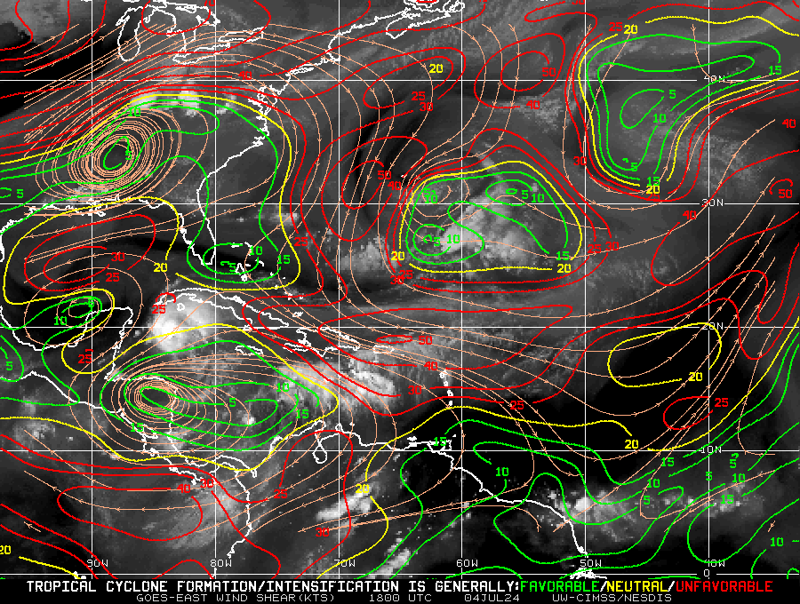
The step left that many models have shown (probably regarding core organization) appears to be happening now, according to the latest recon fix. Models also show the more NW motion resuming in a few hours. Also, shear is abating according to the latesr shear analysis and is probably the most favorable it has been since the Lesser Antilles
.gif.cef3666dfa4b18934c2692ddf6ad60f7.gif)
-
Lady is stripping off its clothes. Latest fix is WSW of the previous one
-
About to splash into the GoM in the next hour or so. It's moving right of the forecasted track.
-
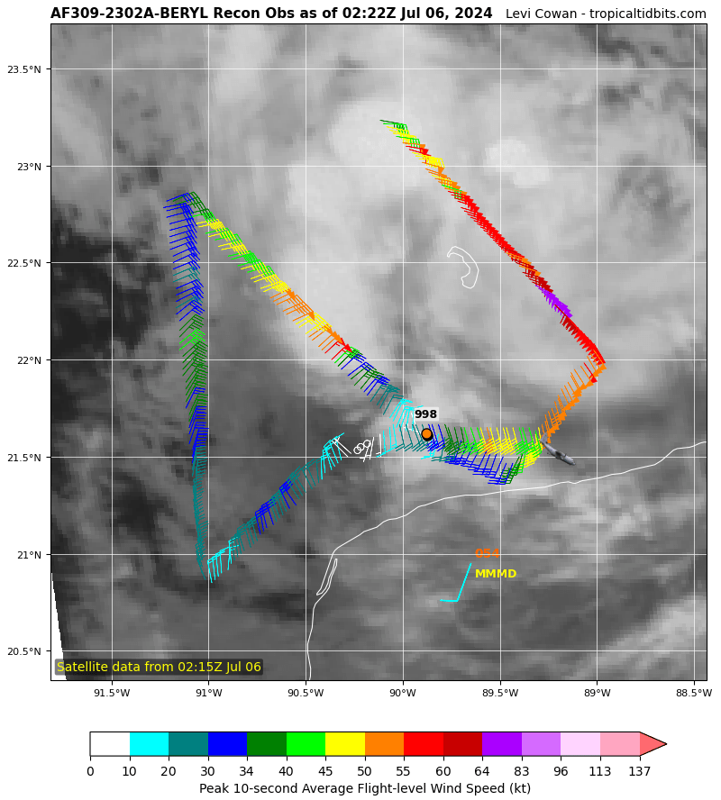
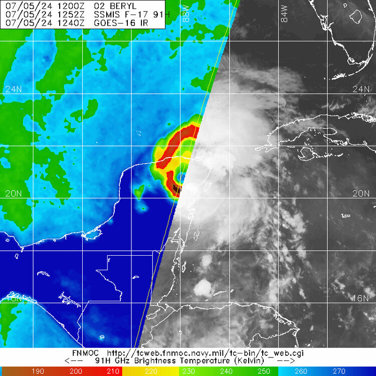
Yeah, that Beryl looks photogenic on MW, surprisingly so, much better than any MW since the Lesser Antilles
-
Recon's extrapolated pressure is 961.9mb. I expect the dropsonde to show values a few mb above that, but still, that would probably be a 8-10mb drop between recon penetrations.
-
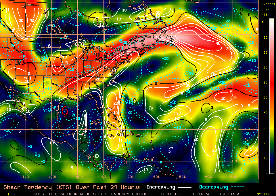
Shear has once again increased according to UWisc CIMSS analysis. That's the cue for the eye clouding over.
.gif.490f3e252bf4532344d9bde28ce46dbe.gif)
-
Latest MW
-
Beryl has been straddling the neutral shear threshold (20kts) her whole trek over the Caribbean. Yesterday, it crossed it into 25+kts of shear, and earlier today it went back to ~20kts. While S of Jamaica After Jamaica Right now
-
I'll say a bit of both. There are definitely structure changes to the core, hence the propensity for wobbles, but i also think that there will be a farther left track from here to the Yucatan, probably not a 270 heading, but around 275/280, gaining a few tenths of latitude before LF
-
Re: Hurricane models and intensity. With the exception of the HMON, they all show more favorable GOM conditions. Regarding track. How much will the central plains trough erode the SE ridge is the central question. Also, if it will eventually hook Beryl up to the NW/N capturing it or not. This is important regarding flooding issues in MX and/or TX. Some of the models, at times, show Beryl completely missing the trough and continue to the W or WNW farther into MX (12z HAFS-X and the CMC), with little TX effects. Most runs show MX landfall, but turning right into TX fairly soon (most GFS runs, and the latest Euro and Ukie). The latter is what's have been favored by the NHC since advisories had shown a W GOM LF.
-
Yes, there is, it's usually structure->central pressure->wind speed ... both in the strengthening and weakening phases.
-
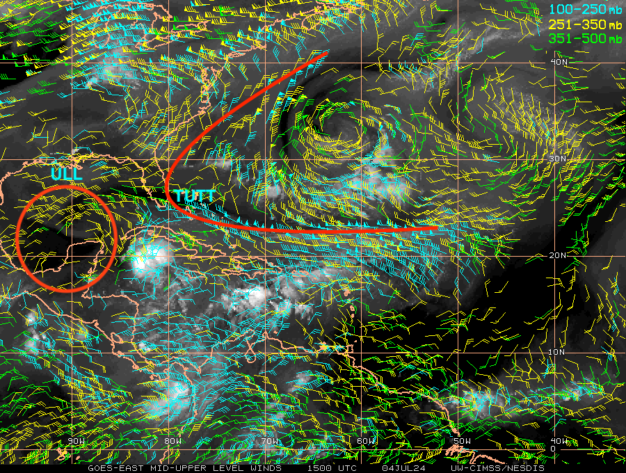
Recon definitely shows a continued gradual weakening, but I think current radar and satellite shows that trend may have halted, if not starting to reverse a bit, at least structure wise. Deepening and intensification may follow suit. I think that the reason is that shear may be abating a bit, due to what I explained above, the ULL pinching off the TUTT, the TUTT slowly lifting up and the ULL redirecting part of the upper level winds around it, instead of impinging the TC. Not saying that it will explode or anything of that sort, but I can see it steady state (or slightly strengthen) before the Yucatan LF. Next recon will dissipate any questions about the weakening trend halting for the time being.
-
The thing is if that the Ukie, CMC and Euro all three have a due west path starting around 19N (which is right now) until the Yucatan, while the GFS has a more poleward track.
-
This is another source for MW imagery @40/70 Benchmark https://www.nrlmry.navy.mil/TC.html
-
The ULL was pinched off the TUTT earlier today and is positioned to the WNW of Beryl. If the distance between the two widens, by the ULL retrograding at a faster pace than Beryl, and/or the ULL filling up and weakening then we would get a very favorable environment in the GOM
-
One thing is for sure, the environmental conditions sure look much better in modeling world than what they were forecasted to be 24 hours ago. The ULL moves away from Beryl faster, with a greater separation between the two, with lot less shear impacting the cyclone, and an ULAC building atop Beryl. If it has a good structure post-Yucatan, then it can intensify significantly before the W GOM LF.
-
A good reference of which models are handling Beryl better for the GOM is whether it hits the Yucatan near 19N (like the CMC, Ukie and 06z Euro do) or 20N (like the GFS and others do). Currently it is at ~19.1N, and a more westward track appears to have begun according to radar and recon.