buckeyefan1
-
Posts
13,278 -
Joined
Content Type
Profiles
Blogs
Forums
American Weather
Media Demo
Store
Gallery
Everything posted by buckeyefan1
-
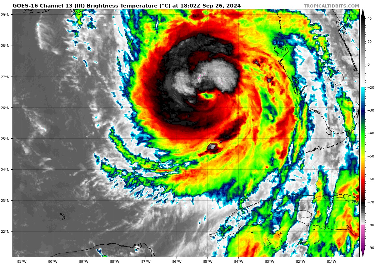
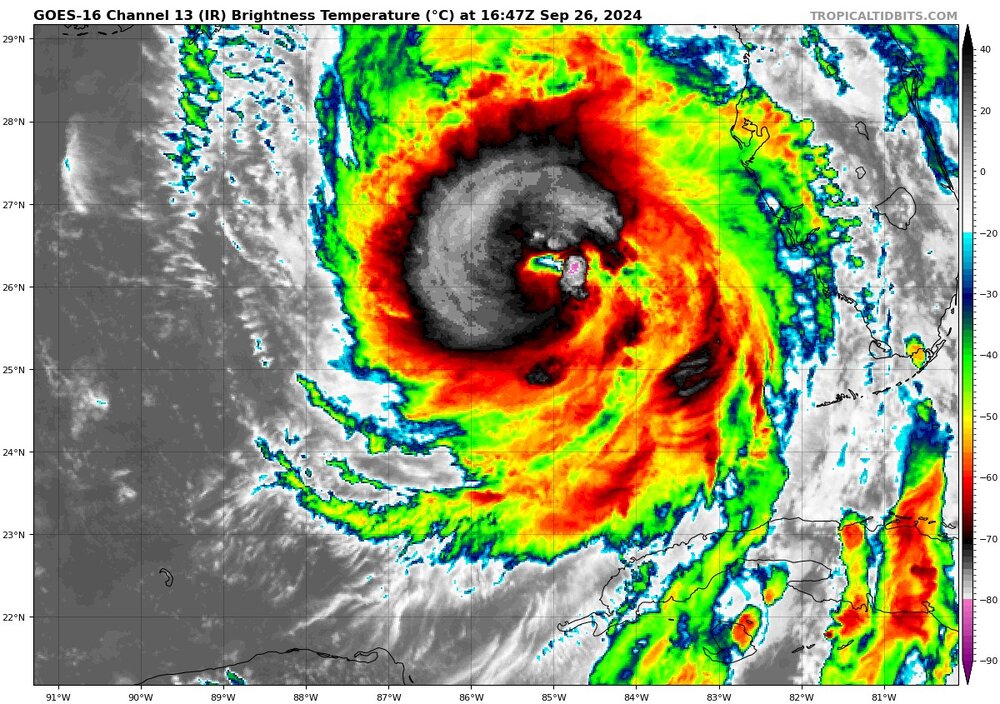
Northern weenies are the worst for sure While they're complaining, Helene has steadily strengthened since her erc overnight and has gone from an 85mph storm to a 110mph storm with continued strengthening until landfall.
-
Almost a cat 3 now 110mph 959mb
-
Me too. I've been through plenty of hurricanes, but none where all of the trees already are leaning on a slope
-
I'm still in shock with the hurricane force winds possible as stated by GSP with 60-70mph to the south. Insane
-
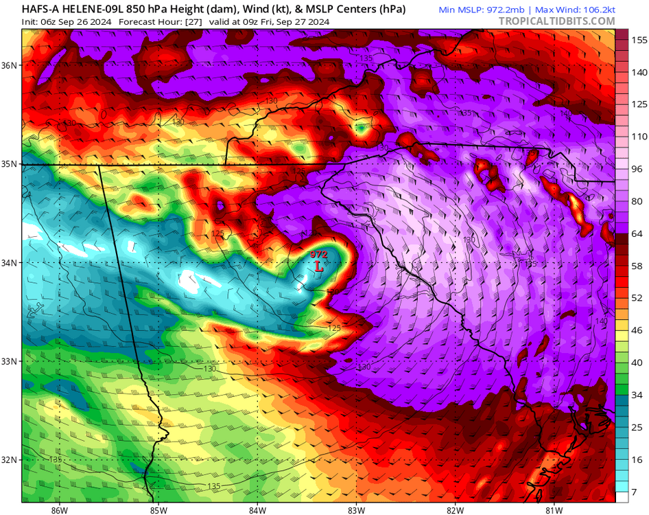
That's a sweet looking tower going up to close off the eyewall
-
It's real
-
Ewwwwww
-
4.4 here so far
-
It doesn't matter what model you look at either
-
Well isn't that just a bundle of sunshine
-
Indeed. MBY is up to 5” and counting, while those just to my north are reporting almost 7”
-
I had a little break from the rain last night, but it’s been pouring now for a few hours. Eyeballing the bucket, I’m over 3” and there’s no end in sight yet.
-
Indeed. Lightning is popping
-
I’m far from being a met, but I’ll say that they’re thinking the ULL pulls it a touch further west as opposed to the usual poleward tug nne-ne?
-
The TS wind field has expanded about 100 miles since the 8am advisory
-
The answer hasn’t changed. Please stop
-
It’s not going to be pretty
-
Helene Local Watch/Warning Statement/Advisory Number 9 National Weather Service Greenville-Spartanburg SC AL092024 1127 AM EDT Wed Sep 25 2024 SCZ104-252330- /O.NEW.KGSP.TR.A.1009.240925T1527Z-000000T0000Z/ Greater Oconee- 1127 AM EDT Wed Sep 25 2024 ...TROPICAL STORM WATCH IN EFFECT... A Tropical Storm Watch means tropical storm-force winds are possible somewhere within this area within the next 48 hours * LOCATIONS AFFECTED - Seneca - Walhalla * WIND - LATEST LOCAL FORECAST: Below tropical storm force wind - Peak Wind Forecast: 20-30 mph with gusts to 50 mph - THREAT TO LIFE AND PROPERTY THAT INCLUDES TYPICAL FORECAST UNCERTAINTY IN TRACK, SIZE AND INTENSITY: Potential for wind 39 to 57 mph - PLAN: Plan for hazardous wind of equivalent tropical storm force. - PREPARE: Efforts to protect property should now be underway. Prepare for limited wind damage. - ACT: Act now to complete preparations before the wind becomes hazardous. - POTENTIAL IMPACTS: Limited - Damage to porches, awnings, carports, sheds, and unanchored mobile homes. Unsecured lightweight objects blown about. - Many large tree limbs broken off. A few trees snapped or uprooted, but with greater numbers in places where trees are shallow rooted. Some fences and roadway signs blown over. - A few roads impassable from debris, particularly within urban or heavily wooded places. Hazardous driving conditions on bridges and other elevated roadways. - Scattered power and communications outages. * FLOODING RAIN - LATEST LOCAL FORECAST: Flood Watch is in effect - Peak Rainfall Amounts: Additional 8-12 inches, with locally higher amounts - THREAT TO LIFE AND PROPERTY THAT INCLUDES TYPICAL FORECAST UNCERTAINTY IN TRACK, SIZE AND INTENSITY: Potential for extreme flooding rain - PLAN: Emergency plans should include the potential for extreme flooding from heavy rain. Evacuations and rescues are likely. - PREPARE: Urgently consider protective actions from extreme and widespread rainfall flooding. - ACT: Heed any flood watches and warnings. Failure to take action will likely result in serious injury or loss of life. - POTENTIAL IMPACTS: Devastating to Catastrophic - Extreme rainfall flooding may prompt numerous evacuations and rescues. - Rivers and tributaries may overwhelmingly overflow their banks in many places with deep moving water. Small streams, creeks, canals, arroyos, and ditches may become raging rivers. In mountain areas, deadly runoff may rage down valleys while increasing susceptibility to rockslides and mudslides. Flood control systems and barriers may become stressed. - Flood waters can enter numerous structures within multiple communities, some structures becoming uninhabitable or washed away. Numerous places where flood waters may cover escape routes. Streets and parking lots become rivers of raging water with underpasses submerged. Driving conditions become very dangerous. Numerous road and bridge closures with some weakened or washed out. * TORNADO - LATEST LOCAL FORECAST: - Situation is somewhat favorable for tornadoes - THREAT TO LIFE AND PROPERTY THAT INCLUDES TYPICAL FORECAST UNCERTAINTY IN TRACK, SIZE AND INTENSITY: Potential for a few tornadoes - PLAN: Emergency plans should include the potential for a few tornadoes. - PREPARE: If your shelter is particularly vulnerable to tornadoes, prepare to relocate to safe shelter before hazardous weather arrives. - ACT: If a tornado warning is issued, be ready to shelter quickly. - POTENTIAL IMPACTS: Limited - The occurrence of isolated tornadoes can hinder the execution of emergency plans during tropical events. - A few places may experience tornado damage, along with power and communications disruptions. - Locations could realize roofs peeled off buildings, chimneys toppled, mobile homes pushed off foundations or overturned, large tree tops and branches snapped off, shallow-rooted trees knocked over, moving vehicles blown off roads, and small boats pulled from moorings. * FOR MORE INFORMATION: - http://scemd.org/planandprepare
-
Helene watch/warning advisory number 9 Nws National Hurricane Center Miami fl al092024 1107 AM EDT Wed Sep 25 2024 This product covers southeast North Carolina and northeast South Carolina **HELENE BECOMES A HURRICANE** NEW INFORMATION --------------- * CHANGES TO WATCHES AND WARNINGS: - A Tropical Storm Watch has been issued for Coastal Georgetown and Coastal Horry * CURRENT WATCHES AND WARNINGS: - A Tropical Storm Watch is in effect for Coastal Georgetown and Coastal Horry * STORM INFORMATION: - About 1010 miles south-southwest of Wilmington NC or about 950 miles south-southwest of Myrtle Beach SC - 21.6N 86.3W - Storm Intensity 80 mph - Movement North-northwest or 330 degrees at 10 mph SITUATION OVERVIEW ------------------ Due to its large physical size Helene will bring some peripheral effects to the area. Very outer tropical bands will be capable of producing moderate rainfall and breezy conditions. There will also be a small but non-zero tornado threat. Hazardous marine conditions will develop with large waves and tropical storm forced wind gusts. The main timing window of these impacts will be late Thursday into early Friday. POTENTIAL IMPACTS ----------------- * TORNADOES: Prepare for a dangerous tornado event having possible significant impacts across Southeast North Carolina and Northeast South Carolina. Potential impacts include: - The occurrence of scattered tornadoes can hinder preparedness actions during tropical events. - Tornadoes can rip roofs from homes, destroy mobile homes, cause trees to become snapped or uprooted, flip cars and boats. Dangerous projectiles can add to the damage. - Several places may experience tornado damage with a few spots of considerable damage, power loss, and communications failures. Prepare for a tornado event having possible limited impacts across Southeast North Carolina and Northeast South Carolina. * FLOODING RAIN: Prepare for dangerous rainfall flooding having possible significant impacts across Southeast North Carolina and Northeast South Carolina. Potential impacts include: - Moderate flooding from rainfall may prompt some evacuations and rescues especially in Northeast South Carolina. - Driving conditions will become hazardous, and some road closures can be expected. Prepare for locally hazardous rainfall flooding having possible limited impacts across Northeast South Carolina and Southeast North Carolina. * WIND: Little to no impacts are anticipated at this time across southeast North Carolina and northeast South Carolina. PRECAUTIONARY/PREPAREDNESS ACTIONS ---------------------------------- * OTHER PREPAREDNESS INFORMATION: When making safety and preparedness decisions, do not focus on the exact forecast track as there are inherent forecast uncertainties which must be taken into account. Always heed the advice of local officials and comply with any orders that are issued. Do not needlessly jeopardize your life or the lives of others. When securing your property, outside preparations should be conducted as soon as possible before conditions deteriorate. The onset of strong gusty winds and heavy rain can cause certain preparedness activities to become unsafe. Visitors to the area should become familiar with nearby surroundings. If you are a visitor, know the name of the county or parish in which you are located and where it is relative to current watches and warnings. If staying at a hotel, ask the management staff about their onsite disaster plan. Listen for evacuation orders, especially pertaining to area visitors. Closely monitor NOAA Weather Radio or other local news outlets for official storm information. Listen for possible changes to the forecast. * ADDITIONAL SOURCES OF INFORMATION: - For information on appropriate preparations see ready.gov - For information on creating an emergency plan see getagameplan.org - For additional disaster preparedness information see redcross.org NEXT UPDATE ----------- The next local statement will be issued by the National Weather Service in Wilmington NC around 5 PM EDT, or sooner if conditions warrant.
-
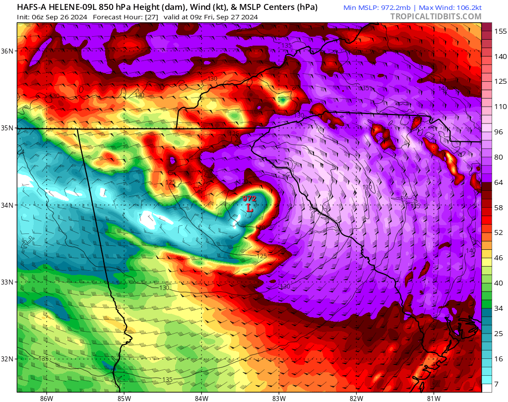
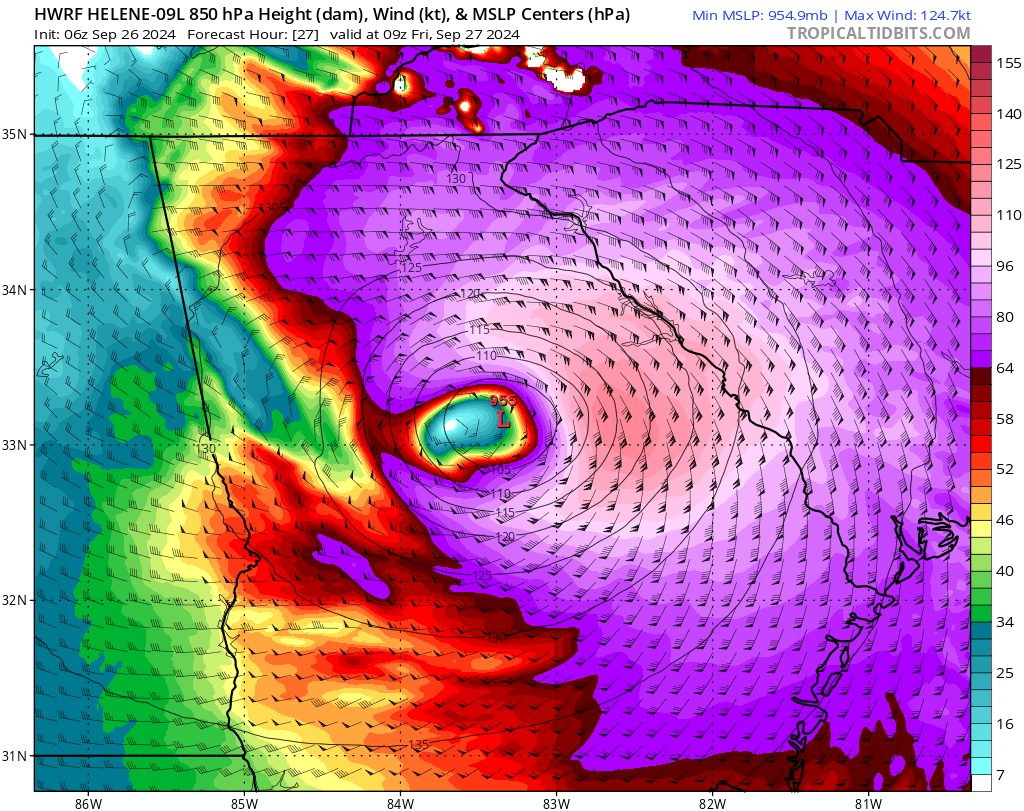
It looks like it has made the turn north, if not just east of north, earlier than expected.
-
1.40 last night and that’s the first rain I’ve had in weeks
-
I was thinking the same thing for the same reasons myself
-
I can’t believe I’m saying this for the second time and it’s not for anything frozen Batteries, water, precooked food, gas tank full, and I’m now ready for my 12”