

buckeyefan1
-
Posts
13,278 -
Joined
Content Type
Profiles
Blogs
Forums
American Weather
Media Demo
Store
Gallery
Everything posted by buckeyefan1
-
Glad you had a safe trip home! My family keeps sending me pictures of a beautiful winter wonderland while I sit with 33 degree rain
-
True story Meanwhile........That’s a lot of rain
-
I don’t think I can remember a Miller A that gave severe weather to the upstate. If it happens, this year would be the icing on the cake
-
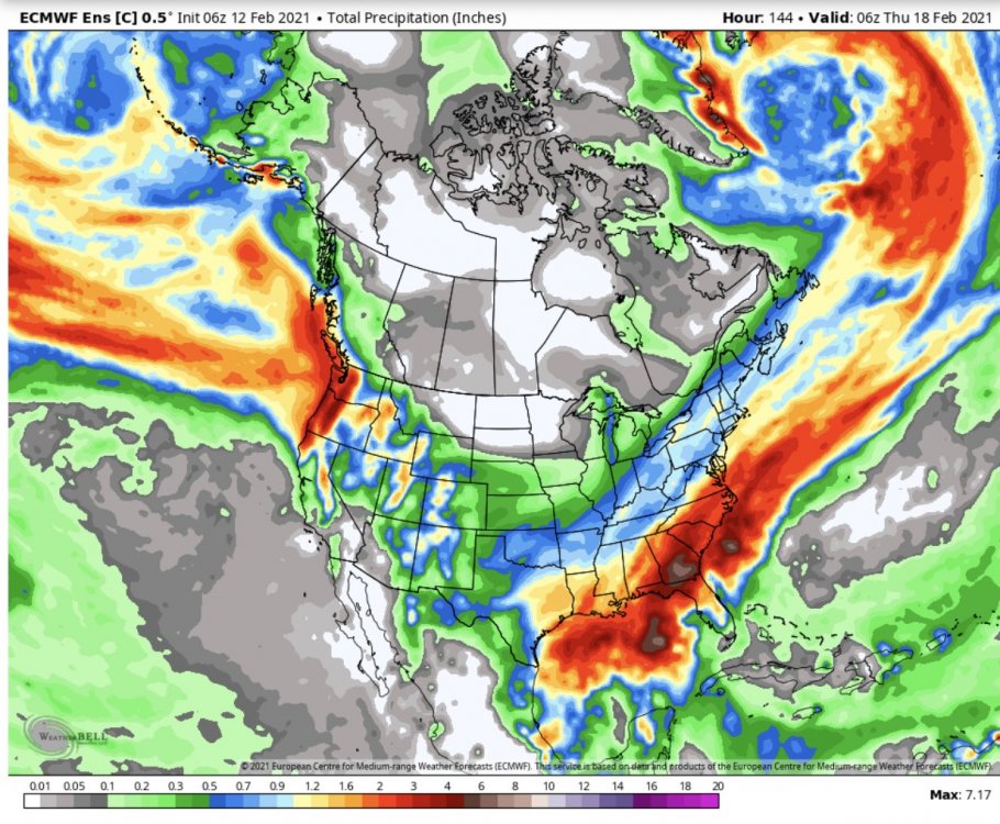
GSP....... .LONG TERM /MONDAY THROUGH THURSDAY/... As of 300 AM Fri: The seemingly endless CAD event continuing early Monday appears likely to be eroded by a cold front and developing sfc low ahead of the upper trough covering the central third of the CONUS at that time. The front most likely will pass our area Monday night, into early Tuesday morning. 850mb LLJ preceding the front peaks near 60 kt into our lower Piedmont zones on both GFS and EC early Tuesday Even with the depicted nocturnal passage, the GFS manages to wring out up to 150 J/kg of SBCAPE, compared to about half that in the same area on the ECMWF. Near-sfc winds are a little veered, but still a period to watch, perhaps. Precip chances finally taper off in the wake of this front, and skies clear for a time, making part of Tuesday and Tuesday night our one break from active weather in this morning`s whole forecast. A dry and colder airmass will settle in behind this front. But then, the deterministic models are seemingly in good agreement on the aforementioned trough sharpening up as it swings in to the eastern CONUS later in the week, and depict Miller A-type cyclogenesis (or a close imitation) circa Thursday. This event still looks to bear some severe weather risk for the area; the GFS is quite bullish on scouring out the wedge, so it is more alarming in the severe weather sense than the EC, which keeps most of the area wedged in. A peek at some EC ensemble members does show a few which are more GFS-like. It`s a bit too early to place much confidence in this aspect of the forecast; the models which typically do better on temps at this range are suggesting the wedge will hold strong, so the forecast leans in their favor. Based on the current blended temp trends and vertical profiles, any mention of wintry weather in the medium range fcst is only warranted as a wintry mix at high mountain elevations.
-
it fits
-
Agree
-
Looks right to me
-
The best virtual storm I’ve ever seen.......sigh........What could have been
-
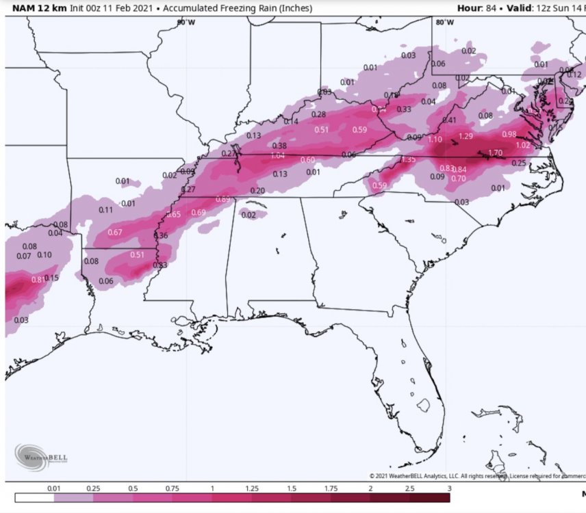
I sure hope it trends colder and you get more sleet than zr
-
Indeed
-
You’ve listened to me complaining for years and years, so you knew what you were in for moving south
-
Right!? After the Xenia tornado, I’ve been hooked ever since As a single Mom and Nana to 3, I get to spend as much time photographing nature as I want, because I can Ewwwwwwwwww!
-
It doesn’t matter if nobody wants to talk about it, there’s probably a greater chance of severe weather than winter weather at this point.
-
I believe we’ll have a very active spring
-
It’s a thunder storm imby with low rumbling, ground shaking thunder
-
Yes because it’s creeping into mby If you’re at 31 degrees or lower when it starts raining, watch out
-
Imagine that
-
Silly NAM continues to creep
-
An absolute perfect 65 degree day after a morning low of 38
-
The past two days have given me a touch of spring fever You and me both! I was looking forward to waterfall hopping here, with icicle’s and a blanket of snow as my landscape
-
Severe, tropical, drought, fires, earthquakes.....you’ll find them here and the main board where all the sub forums gather
-
Now you’re just rubbing it in I’m jealous! My niece sent me a video of my great nephews (5&8) outside playing in the snow today and it was at and above their knees I was there last fall and winter and managed one single 2.5” front end thump before it was washed away in the rain
-
As aggravating as you are, I’d miss the (not) bouncing turd if you weren’t here OMG THIS! BTW......Everything is fixed with snow and chocolate
-
Look, I’m sorry your friend isn’t doing well. Covid freakin sucks. My daughter is now on day 42 with covid symptoms , still testing positive and nobody knows if the painful inflammation will ever go away because with the people that have the same condition haven’t had any lessening of the symptoms. She has lung damage and I’m sure other things damaged. I understand we all handle things differently, but it’s no excuse. You did the same thing last winter when I had to say something to you then too. Do better. Thank you.
-
I miss having you guys in the se I you


