buckeyefan1
-
Posts
13,278 -
Joined
Content Type
Profiles
Blogs
Forums
American Weather
Media Demo
Store
Gallery
Everything posted by buckeyefan1
-
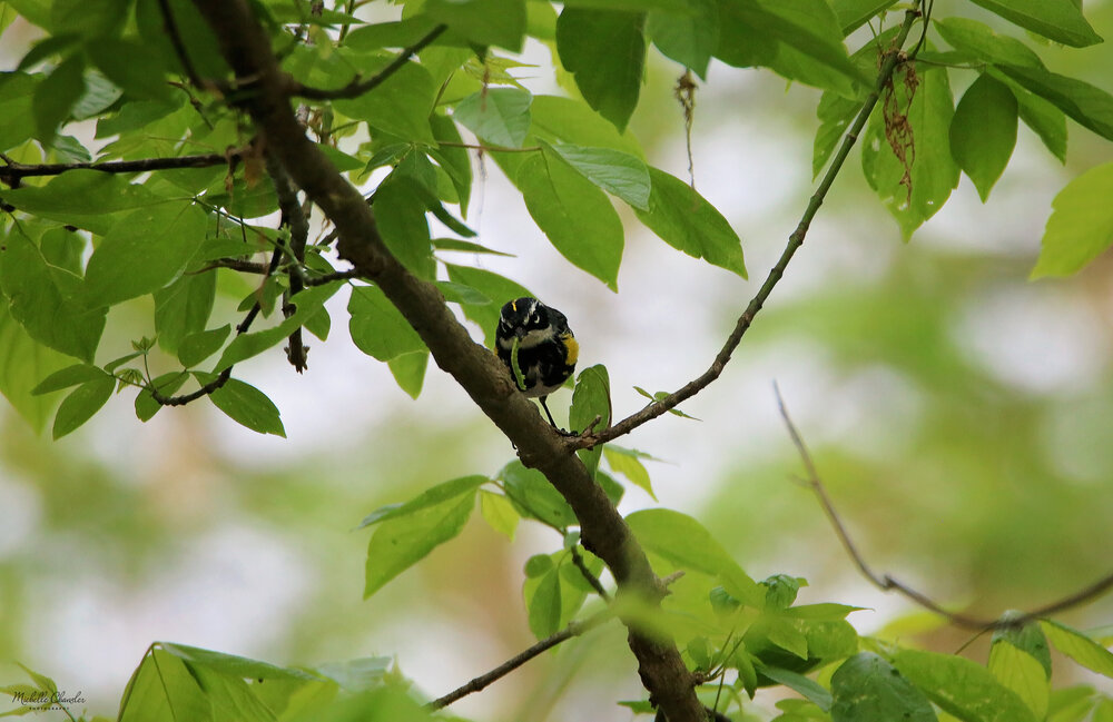
Yellow rumped warbler with a snack
-
This is beautiful
-

Mid to Long Range Discussion ~ 2022
buckeyefan1 replied to buckeyefan1's topic in Southeastern States
Still looking good and hopefully this summer will be closer to average than not -
Baby toes

-
I love these! Red and black are my favorite colors
-
Mid to Long Range Discussion ~ 2022
buckeyefan1 replied to buckeyefan1's topic in Southeastern States
Right!? Unless it's cooler than average temps in May, and that looks like an excellent possibility -
Mid to Long Range Discussion ~ 2022
buckeyefan1 replied to buckeyefan1's topic in Southeastern States
I'm loving these cold fronts -
58/80 today and the front can't come soon enough. I'm looking forward to temps in the mid 60's next week
-
Thank you. She was my heart.
-
I think he was hangry

-
That is a greater snowdrop Love these!!
-
From South Carolina Emergency Management Department Facebook page Initial Damages from April 5-6 Storms Columbia, S.C. (Thursday, April 7, 2022) – The South Carolina Emergency Management Division and local emergency managers continue to assess damage in counties impacted by this week’s severe weather and tornados. No deaths have been reported as a result of these storms in South Carolina. As of 3 p.m. today, the SCEMD Recovery Section reports damage in the following counties: Allendale: Four homes destroyed, 11 homes damaged, 15 homes impacted in total. Local emergency management officials report three non-life-threatening injuries. Bamberg: Five homes destroyed, 15 homes damaged, 20 homes impacted in total. Clarendon: Three homes destroyed. Horry: Five homes damaged, none destroyed. Orangeburg: Two homes destroyed, 10 homes damaged, 12 homes impacted in total. With more detailed assessments ongoing, these estimates will be revised in the coming days. Tornado survey teams with the National Weather Service have confirmed at least five tornados ranging from ESF-1 to EF-3 intensities. Meteorologists identified damage consistent with an EF-3 tornado in Allendale County. NWS surveys will also continue. Residents should report storm damage to their local officials or by using the damage assessment tool in the SC Emergency Manager mobile app in the Apple App Store (https://itunes.apple.com/.../sc-emergency.../id1378105431...) and on Google Play (https://play.google.com/store/apps/details?id=org.scemd.app).
-
Strong rotation showing up just past WIlliston heading to Neeses, North and St. Matthews
-
Brett Adair in Sumter County Ga showing a TOG
-
Good luck with that anywhere this time of day Actually Hell Hole Road would be the perfect place to intercept. EDIT: You'd have to know the roads well in the forest though
-
Frances Marion has some pretty good roads and some pretty bad ones. Not the place to be when it rains. It gets washed out quick in areas.
-
Pretty tight rotation with it
-
Brad P posted this map a few minutes ago
-
Corey's video was on TWC btw.....Lucky the dog is fine. Lucky was born under my Daughters shed and we rescued and found excellent homes for him, his siblings and his mom. https://fb.watch/ccAURT9--O/
-
Nobody ever said southern rednecks were smart
-
Sorry Multitasking fail
-
Harleyville to Eutawville should take cover now. Radar indicated tornado heading your way. Also Manning should take cover. Weak circulation coming out of Summerton. Not warned yet.
-
There's some pretty good video of it here on WTOC https://www.wtoc.com/2022/04/05/reports-storm-damage-bryan-co/
-
This was sent to me from Corey who works at R and R. This is the same tornado that had just went through Allendale according to his father who was pulling into R and R after leaving Allendale. Corey was going out of the back door when he filmed this. The complete video is too large for me to upload here, but you can see it now on WLTX as he sent it there after he sent it to a few of us. There are only 8 miles that separate Allendale and Ulmer.
-
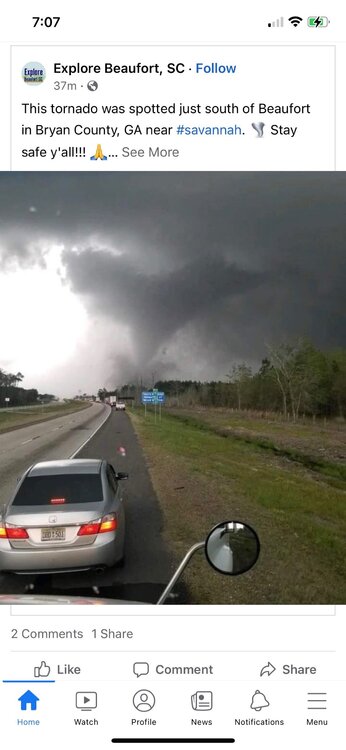
here’s the tornado that is heading towards Beaufort. This is Bryan county in GA. Take cover in Beaufort