michsnowfreak
-
Posts
18,455 -
Joined
-
Last visited
Content Type
Profiles
Blogs
Forums
American Weather
Media Demo
Store
Gallery
Everything posted by michsnowfreak
-
Love it! Ill be in Alaska
-

2026-2027 Super El Nino
michsnowfreak replied to Stormchaserchuck1's topic in Weather Forecasting and Discussion
Ignorance really is bliss with the trolls. -
Im not an ASOS fan either. Needs way more babysitting/calibrating than a traditional thermometer. And it still sucks with melting down dry snow. The old fashioned way is the best imo. My rain, snow, and liquid equivalent in snow are all done the traditional way.
-
2026-2027 Super El Nino
michsnowfreak replied to Stormchaserchuck1's topic in Weather Forecasting and Discussion
There was a 3" snow Nov 14 and another 1.6" the 15th. I dont remember forecasts that long ago (I was young lol). Mid november to mid December, the 2nd half of january, and spurts of March were wintry. The rest sucked. -
2026-2027 Super El Nino
michsnowfreak replied to Stormchaserchuck1's topic in Weather Forecasting and Discussion
Even though its clear who the trolls are, its a shocking lack of understanding how the actual weather works. -
2026-2027 Super El Nino
michsnowfreak replied to Stormchaserchuck1's topic in Weather Forecasting and Discussion
I would like to see this cold bias documented too. Bias would mean it regularly runs too warm/cold. Cansips was the only model close to the cold in the great lakes and northeast last winter. Does that mean every other model has a warm bias? -
2026-2027 Super El Nino
michsnowfreak replied to Stormchaserchuck1's topic in Weather Forecasting and Discussion
We all know this but its alwags good to remind ourselves....even with very similar indices, an analog is an analog. The weather itself will always play out differently. -
I use https://xmacis.rcc-acis.org/ Very easy to rank different variables, years, etc. Ive used it for years. Excellent resource.
-
The usual cold spots in SE MI tanked this morning. 39F at Ann Arbor. With the cool mornings keeping the house cool and fresh, theres been no need for the AC in the afternoon. That will change tmrw or definitely Thursday. Regardless, why cant we have this low humidity all summer!
-
2026-2027 Super El Nino
michsnowfreak replied to Stormchaserchuck1's topic in Weather Forecasting and Discussion
Unpopular opinion here. 1997-98 wasnt AS bad as it gets a rep for in the Great Lakes. It sucked, but an nunprecedented shutout (just a T) in February sealed its fate in infamy. Nov-Jan was ok, multiple rounds of snow (then a few more in March). The 2nd half of January was solid white ground and gray skies and the temp barely moved. Good enough for snow but I imagine terrible for ice fishing. Still high on the list of winters I dont care to ever see again, but significantly better than 1982-83. -
Pretty pumped that after a coolish May ill be looking at a 10 day alaskan forecast with highs/lows in the upper 50s/upper 40s dominating. Really makes the summer more tolerable when you shorten the heat part.
-
2026-2027 Super El Nino
michsnowfreak replied to Stormchaserchuck1's topic in Weather Forecasting and Discussion
December 2015 was just a trainwreck but the rest of the winter wasnt bad here. There was actually a very scenic snowstorm Nov 21st then it was quiet snow-wise til early January. One of the hallmarks of strong ninos tends to be one real shitty month and the rest of the time ok. -
2026-2027 Super El Nino
michsnowfreak replied to Stormchaserchuck1's topic in Weather Forecasting and Discussion
Its the primary key for how stormy/snowy winter will be. But you absolutely have to expect thaws/non-winter stretches in a strong nino. The snow season lasts Nov-Apr, so unlike last winter which was steady cold/white during DJF, you go into this winter knowing there will be interruptions and shitty spells but if you can settle into an active pattern, plenty of snow chances too. -
Spring finished tied w/ 1987 & 2000 for 8th warmest on record of 153 at Detroit. Naturally it was 100% due to March/April, as May finished cooler than avg. An about face from the 44th coldest winter.
-
indeed In 2023 when Detroit failed to surpass 90F for the first time since 1915, I was told it was the wildfires fault that the max temps were held down. The warmer summer mins were noticeable in holding up the avg temp. NOW....the mins are lower because of an ASOS upgrade . Whats funny...is that the mins STILL run warmer at Detroit (DTW) than all surrounding areas. So I guess every other AWOS, personal weather station etc is in on the min temp conspiracy. The 2026 min temp to date (Jan-May) at DTW is 31.1F. Just 10 miles west at YIP it is 29.4F at 25 miles west of DTW it is 26.7F. Even 25 miles NE in the actual city, Detroit City airport min temp is 31.0F. DTW 31.1 DET 31.0 YIP 29.4 ARB 26.7 Looking at the cold month of January, mins at those same locations: DTW 13.8 DET 14.9 YIP 12.0 ARB 9.0 DTW is the only regulated ASOS station, so it would be the only one that this mysterious min mania applies to. And yet, it is the warmest in the area year-to-date.
-
2026-2027 Super El Nino
michsnowfreak replied to Stormchaserchuck1's topic in Weather Forecasting and Discussion
I do. -
2026-2027 Super El Nino
michsnowfreak replied to Stormchaserchuck1's topic in Weather Forecasting and Discussion
Yeah. ENSO affects winter the most, with more subtle effects in summer/Fall. I absolutely love Fall, so Im hoping that its a seasonable October. Some strong Nino falls tend to be cool, but if this strong nino isnt acting like one, then who knows? -
2026-2027 Super El Nino
michsnowfreak replied to Stormchaserchuck1's topic in Weather Forecasting and Discussion
Weve always discussed the weather in the ENSO threads. Im really going out on a limb here, but I have a feeling the Cansips not caving from its cold idea is what prompted that suggestion. -
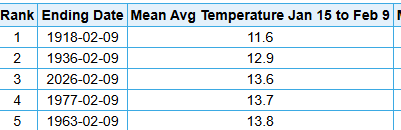
I know everyone already knows this, but TCC and twitter/x handler TheGlobalWarmer are the same person, so in addition to always quoting/replying to his own posts, TCC is now embedding his own TGW tweets. Detroit got a special shout out because I corrected the BS of a normal winter with transient cool shots by posting the actual mean temp maps showing it was a cold winter in the east. This year has been unusual in many areas due to the large diurnal swings. This is why TCC has suddenly abandoned actual avg/mean temps for max temps only. Due to the very warm Mar/Apr, the year is still running above avg to date, despite the fact that Mar/Apr are the only warmer than avg months since October. Detroits avg max temp year to date of 50.2F ranks 19th warmest....but the avg min temp of 31.1F is tied with 6 other years for 59th warmest. Thus, the actual mean temp is 30th warmest to date, tied with 3 other years. It stuck in the craw of the heatmisers that it was an unexpectedly cold winter in the Lakes/east, so theres plenty of excess energy to burn after a warm spring. With the record warmth out west, it was seen as criminal that people in the east were discussing the cold winter where they lived rather than the warm west where they didnt live. And again, no one was acting like this was some record cold winter...it was just a consistently cold, white winter, esp from MI eastward, despite the fact that some tried to paint it as normal. Jan 15-Feb 9th was the 3rd coldest on record at Detroit. Extend that out 4 days to a full month-period (intra month, a stat we have seen posted here many, MANY times wrt warmth), it was the 11th coldest 30-day period on record for Detroit Jan 11-Feb 9th. Quite a transient cool shot! Dec-Jan combined ranked 36th coldest out of 153 years, although the actual avg min temp during this timeframe ranked 26th coldest out of 153 years. The entire winter 2025-26, with a mild 2nd half of Feb, ranked 44th coldest out of 153 years, but the avg min temp for DJF ranked 31st coldest out of 153 years.

-
May finished as the 5th colder than avg month of the past 7. However, due to the extreme nature of the Mar/Apr warmth, the year-to-date is still running warmer than avg. Nov: -0.4 Dec: -3.6 Jan: -5.2 Feb: -0.2 Mar: +4.9 Apr: +4.2 May: -1.6
-
2026-2027 Super El Nino
michsnowfreak replied to Stormchaserchuck1's topic in Weather Forecasting and Discussion
Ive noticed that too...and im certainly NOT one of them lol. I love cold. But it goes without saying that "cold" and "mild" are extremely subjective terms. Cold in Detroit is different than cold in NYC, to say nothing of the difference between NYC and where you live, and so on. A mild winter here will still be cold enough to snow much of the time. This is why as always storm track/pattern is more important than just temps. I hear the east coast guys talk of their worst winters where they can count on on one hand the number of times it snowed. Its a lock that its going to snow here dozens of times...the key is will there be worthwhile storms? Will it be abnormally dry? And so on. -
2026-2027 Super El Nino
michsnowfreak replied to Stormchaserchuck1's topic in Weather Forecasting and Discussion
Cfs will change only a thousand more times before November. -
2025-2026 ENSO
michsnowfreak replied to 40/70 Benchmark's topic in Weather Forecasting and Discussion
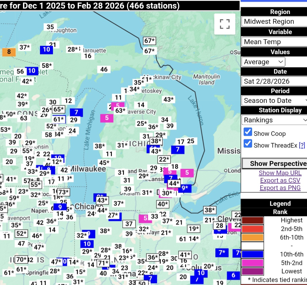
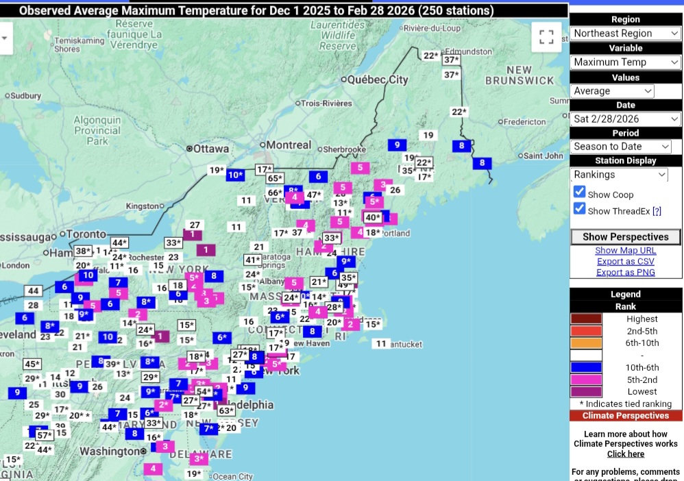
Not to mention more selective cherry picking. He always selects whatever variable and time frame is the warmest. There's been an unusually high (especially for recent decades) diurnal range this year. So the mins are much lower in ranking than maxes. As you said, broken record. The usuals didnt peep a word about the cold winter but once the unusually warm march/April hit they returned in full force. I mean how many ways can you say it? March/April were very warm and the rest of the time since November was not. Here is the WINTER AVG TEMP rankings this past winter. No selected variables, no selected time frames, just the average rankings for the mean winter temp. Warm west/cold east. Imagine that.
-
2026-2027 Super El Nino
michsnowfreak replied to Stormchaserchuck1's topic in Weather Forecasting and Discussion
Not sure about the NE but here my early gut call is of the 3 DJF months to expect one good winter month, one terrible (ie warm, little snow) winter month and the third is a wild card. I also expect early and late season snow. -
Wow guess it was all over the region haha. Highs/lows in SE MI: DTW official- 81/48 Detroit City- 83/47 Flint- 81/41 Monroe- 81/42 But the winner... Ann Arbor- 80/38 Unofficially here was 80/45.