michsnowfreak
-
Posts
16,673 -
Joined
-
Last visited
Content Type
Profiles
Blogs
Forums
American Weather
Media Demo
Store
Gallery
Everything posted by michsnowfreak
-
yes but DET was also 88 on the 4th and 89 on the 5th, so their streak, even with the extra day, was only 5 consecutive days.
-
The max temps in this heatwave won't be overly impressive, but the longevity will.
-
The grass is starting to get very Brown here yet the rivers and lakes remain high
-
Can't say I disagree. Hopefully just slightly warmer than avg though. La Ninas certainly make me lick my chops for potential into the Winter, as above average precipitation is likely.
-
Hopefully either a fluke or a sign that they will keep those high departures out in the plains lol
-
Impressively chilly morning for mid June in Southeast Michigan today. 46 at DTW missed the record low by 4° (however if that was tomorrow it would be the record low). But most of the more outlying areas in Southeast Michigan fell to 38 to 42゚ I actually wonder if some of the high elevations of the northern suburbs had a brief light frost?
-
It's ridiculous and I'm sure the fool amateur weather pages that spread fake news and 16 Day GFS plots which transition into the public mocking meteorogists for being "wrong" is behind this proposed change. I voted strongly against it.
-
first 90 of the year logged at DTW, just barely.
-

Spring/Summer 2020 Banter/Complaint Thread
michsnowfreak replied to IWXwx's topic in Lakes/Ohio Valley
crazy stuff even for out west. 2019-20 was actually the longest snow season on record at Detroit from the first to last measurable snow (Nov 7 - May 10). -
Pure Michigan
-
Speaking of hot and humid, after having the furnace running for nearly 8 months, I literally switched right to the AC today as we have soared to 86゚ with high humidity. However next weekend looks much cooler.
-
I don't mind a few hot and humid days because I know that cold rules the year here. Because of my reputation of loving Winter, it's funny that some people assume I don't like summer when I actually do. Especially being surrounded by lakes. Im just ready for fall by August lol. But the thought of living in some of those Southern climates where unbearable heat and humidity lasts for 5-7 months without a break, then "Winter" is limited to a few freezes at night is truly a nightmare to me. But to each their own!
-
Sounds like a nightmare climate lol
-
Winter of 2019-20 IN PICTURES - Southeast Michigan
michsnowfreak replied to michsnowfreak's topic in Lakes/Ohio Valley
It certainly did! Definitely need to update....now I feel safe in saying the 2019-20 snow season is a wrap....I think . Flakes will resume flying in perhaps just 5 short months. May 2020 - 0.7" of snow A cold May brought a very memorable, record-breaking cold snap during the 2nd week of the month. At Detroit, snowflakes fell on 5 consecutive days (May 8-12), a feat never before seen. Any snow in May is rare, let alone on 5 days. In addition to record low temps, a burst of heavy snow late in the evening on Mother's Day left Detroit with 0.5" of snow, making it the heaviest May snow in 97 years, the 3rd latest measurable snow on record, and the 4th snowiest May on record. This also made 2019-20 the "longest" snow season from first to last measurable snow (Nov 7 - May 10). 5-8-20 snow flurries and snow showers fell off and on all day, a first for my birthday 5-10-20 Rain developed late on Mothers Day, suddenly turning to heavy wet snow around 11pm. It was unlike Id anything Id ever seen in May, and almost mid-May to boot 5-11-20 while the snow was gone by sunrise, May 11th did begin a winter wonderland. I measured 0.7", with 0.5" at DTW, and up to 2" NE of Detroit Third times the charm lol... WINTER TOTAL SNOWFALL (Wyandotte, MI) 2019-20: 43.8" 2018-19: 31.9" 2017-18: 62.5" 2016-17: 41.6" 2015-16: 35.0" 2014-15: 48.5" 2013-14: 96.2" 2012-13: 47.9" 2011-12: 25.5" 2010-11: 69.4" 2009-10: 46.1" 2008-09: 64.8" 2007-08: 78.2" 2006-07: 36.6" 2005-06: 41.9" 2004-05: 80.7" 2003-04: 36.6" 2002-03: 66.9" 2001-02: 42.5" 2000-01: 47.3" 1999-00: 29.3" 1998-99: 52.1" 1997-98: 27.2" 1996-97: 35.9" 1995-96: 31.3"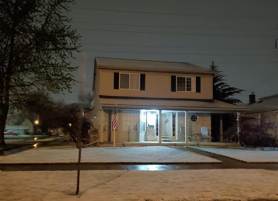
-
Not sure on Genesee County, however the map nicely represents the unusual fact of how the east side of Southeast Michigan did better than the west side. Then again, a lot of it was synoptic quirks as there was not much lake effect snow accumulation this Winter ( No coincidence that the greatest negative departures in the snowbelt of Southwest Michigan). Metro Detroit is split between the 75-100% of average & 100-125% of average categories, but more or less it was an average snow season in the Detroit area, though it came about in any way but average.
-
Final
-
May 2020 cold snap; record cold, possible snow?
michsnowfreak replied to michsnowfreak's topic in Lakes/Ohio Valley
While Detroit only saw a trace of snow in October, I noticed that the DTX NWS office in White Lake, which is about 25 miles northwest of Detroit in the highest elevations of Southeast Michigan, did see measurable snow in October. So regardless of the fact that they ironically missed out on much of the April snow fun for being too far north, they pulled off the rare feat of having measurable snow fall 8 months in a row. Detroit's far northern suburbs almost always get extra early and late season snow accumulation when down here the snow does not stick or fall as rain, yet mid April to mid May of 2020 they were consistently too far North to see the best snow. So crazy. Oct- 0.7" (.....dtw T) Nov- 11.1" (.....dtw 9.5") Dec- 6.7" (.....dtw 2.7") Jan- 9.9" (.....dtw 9.7") Feb- 18.2" (.....dtw 14.7") Mar- 1.7" (.....dtw 1.7") Apr- 0.9" (.....dtw 4.9") May- 0.2" (.....dtw 0.5") -
May 2020 cold snap; record cold, possible snow?
michsnowfreak replied to michsnowfreak's topic in Lakes/Ohio Valley
DTW low was 32゚, so no record for the day (if it had been yesterday or tomorrow it would have been a record though). Regardless this crazy may stretch is coming to an end and spring looks to finally have sprung. There were officially 3 freezes at Detroit this May, which ties with 1978 and 1907 for the 2nd most on record. Only 1966 had more with 5. Of course the areas away from the urban heat island had more than 3 freezes this month. -
May 2020 cold snap; record cold, possible snow?
michsnowfreak replied to michsnowfreak's topic in Lakes/Ohio Valley
Now to look at some of the records from this May cold snap at Detroit. DAILY RECORDS May 08 - Record daily snowfall, Trace May 09 - Record low, 27F May 10 - Record daily snowfall, 0.5" May 11 - Record daily snowfall, Trace May 12 - Record daily snowfall, Trace OTHER RECORDS & ODDITIES ~3rd coldest May temp (27F) on record (only behind 25F on May 10, 1966 & 26F on May 1, 1978) ~2nd latest hard freeze (28 or lower) on record (behind only 25F on May 10, 1966) ~4th snowiest May (0.5") on record, tie w/ 1902 (behind only 1923 (6.0"), 1883 (5.0"), 1912 (1.5")) ~3rd latest measurable snow on record (behind only May 13, 1912 & May 21/22, 1883) ~First May to ever record snow on FIVE separate days (previous record 4 days in 1954...only 3 Mays have ever had snow on 3+ days, 1907, 1954, 2020) ~First May to ever record snow on FIVE CONSECUTIVE days (previous record 3 days in 1954) ~LONGEST snow season on record from first to last measurable snow (186 days, Nov 7 - May 10) ~12th longest snow season on record from first to last measurable flake (195 days, Oct 31 - May 12) ~Snow fell on 11 days from Apr 14-May 12) ~Avg temp for the week of May 5-11 was 44.7F, 2nd coldest on record ~Avg LOW temp for week of May 5-11 was 34.3F, the coldest on record -
May 2020 cold snap; record cold, possible snow?
michsnowfreak replied to michsnowfreak's topic in Lakes/Ohio Valley
You honestly cannot make this up. Detroit was on the way to a record low when all of a sudden an unforecast deck of clouds and snow flurries decided to develop and roll through from 5-7am. The overcast kept the temp steady at 34゚ for hours, but it added another trace of snow to this crazy May. Ann Arbor actually reported 0.1" of snow this morning. So this is now 5 days in a row Detroit has recorded snow . In fact, previously no snow had ever been recorded on May 11th or 12th. -
May 2020 cold snap; record cold, possible snow?
michsnowfreak replied to michsnowfreak's topic in Lakes/Ohio Valley
-
May 2020 cold snap; record cold, possible snow?
michsnowfreak replied to michsnowfreak's topic in Lakes/Ohio Valley
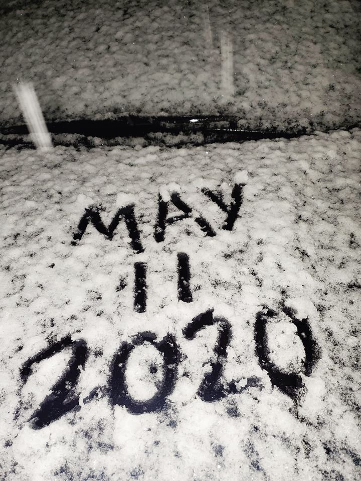
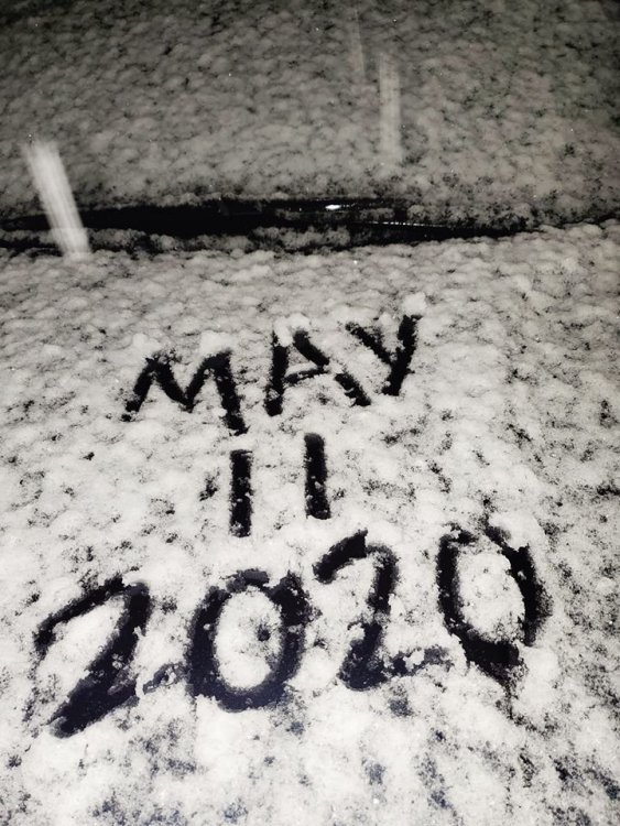
oh geez I accidentally deleted my post lol. Trying to add a gif I made. Oh well. Anyway, it was just incredible to see the heavy snow for May 10/11. I have never seen anything like it so late in the season. I will look up stats later, because its a May to remember, but seeing the rain suddenly turn to heavy snow and accumulate was just unreal for MID-MAY. I picked up 0.7" of snow, which was all gone by morning (the heavy snow lightened up then turned back to rain as it ended, and the temp rose back to the mid-upper 30s. Unfortunately very few snow reports due to the fact that this was a late evening into early overnight event, and also the accumulation was confined to far eastern MI. West of a DTW-PTK line, only a trace fell. DTW had 0.5", with 0.7" here, and social media reports of around 2", possibly more, in parts of Macomb & St Clair county. -
May 2020 cold snap; record cold, possible snow?
michsnowfreak replied to michsnowfreak's topic in Lakes/Ohio Valley
great pics. What city was the video with the accumulation that looked close to 2"? -
May 2020 cold snap; record cold, possible snow?
michsnowfreak replied to michsnowfreak's topic in Lakes/Ohio Valley
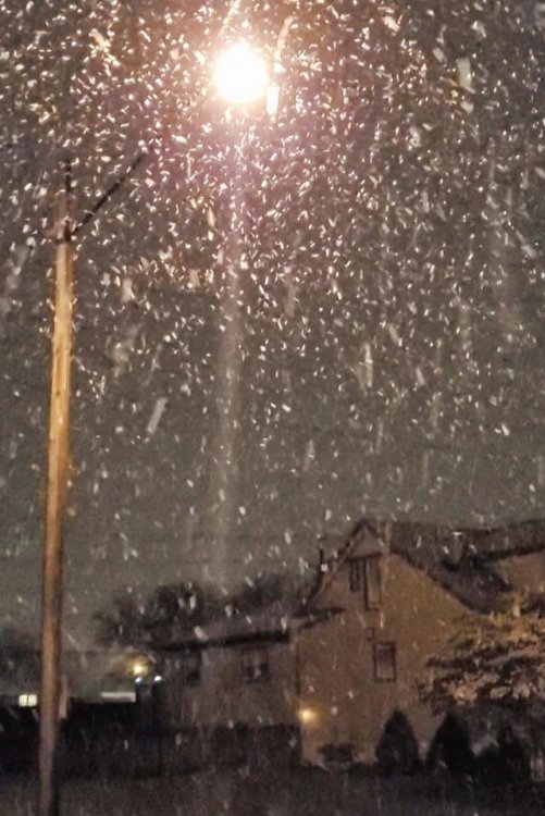
I've never seen a more wild night in May before. I could hear the rain pelting on the roof then almost instantly it turned silent, I looked outside and absolutely pouring huge dendrites. The snow stuck immediately and it continued to pour snow for over an hour, then as the heavy returns moved out the snow lightened up and began mixing back with rain and now it is all rain. It turned into an instant mid may Winter wonderland, 0.7" of slushy snow, and now it is almost all gone a few hours later. Will post pics tomorrow, so crazy. -
May 2020 cold snap; record cold, possible snow?
michsnowfreak replied to michsnowfreak's topic in Lakes/Ohio Valley
Snowing like crazy and sticking. May 11th. So crazy