

ValpoVike
-
Posts
545 -
Joined
-
Last visited
Content Type
Profiles
Blogs
Forums
American Weather
Media Demo
Store
Gallery
Everything posted by ValpoVike
-
Icky and smoky up here. The consolation is that it is not local smoke…yet.
-
Same here, where it is a bit frustrating to see decent QPF all around me. Meanwhile I have been clocking a steady .05"/day for quite some time. But even that I will take.
-
We have done a little better up here. It was dry until a week ago, and over the past week we have had daily .05” rains or so. The past two days have logged a quarter inch each. Not a ton, but better than it could have been. Temps have been quite seasonally average up here, likely tempered by 2pm’ish daily rains and cloud cover.
-
Yeah, no pings!
-
My new truck is at Wally Park, so was extremely curious. Guess I will know for sure on Tuesday!
-
Does anyone know if DIA received damaging hail?
-
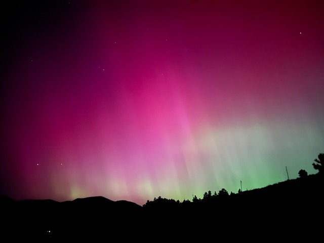
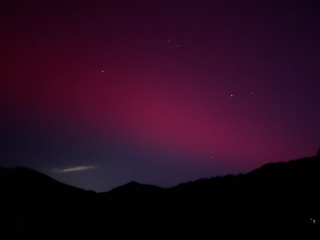
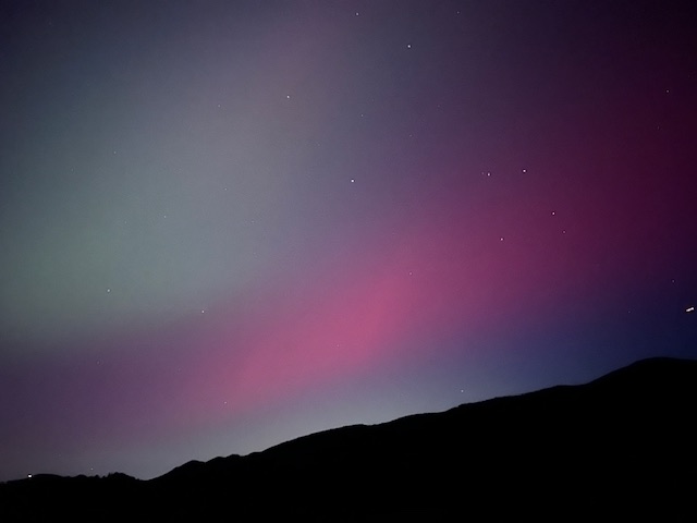
Up here and with good dark skies, starting around 9:15pm I could just make out the aurora but when I pointed my iPhone, and wow. I got some excellent photos and the aurora filled the sky in all directions. Around midnight the aurora brightened very considerably and was easily visible with the naked eye, but only to the northwest. I hadn’t see and aurora since the Halloween storm in 2003. The first image is at midnight and the others from earlier in the night all taken in Glen Haven
-

Mountain West Discussion- cool season '23-24
ValpoVike replied to mayjawintastawm's topic in Central/Western States
Yep, I noticed that too. They seem to try to give winter one last unwelcomed gasp. EDIT: I just checked 12z and both are backing off. -
Mountain West Discussion- cool season '23-24
ValpoVike replied to mayjawintastawm's topic in Central/Western States
Final tally was 1.72” liquid. Really great moisture. -
Mountain West Discussion- cool season '23-24
ValpoVike replied to mayjawintastawm's topic in Central/Western States
I think it is basically done here. Accumulations were marred by the very high water content and the most I could measure was 5.5” due to compaction and melting. My weather station is showing 1.05” of liquid but I don’t have a heater on it so I’m not certain on the actual amount.
-
Mountain West Discussion- cool season '23-24
ValpoVike replied to mayjawintastawm's topic in Central/Western States
About 3” here so far with a temp of 32. -
Well, there is now a warning out for the foothills for up to a foot below 8500', and up to 2 feet above...
-
Looks like NWS is starting to ramp up the foothills. All of the models are now quite bullish on snowfall, and from what I can see from about 7k' and up...as well as the Palmer Divide. NWS is highlighting 8.5k' and up, and nothing highlighted for the Palmer Divide.
-
Look at GFS...yowzers
-
The last two events have been similar. Forecasts and AFDs have been very conservative while the GFS and Euro held steady for many days, and they seem to verify and slit the difference on accumulation. I am interested to see what happens here.
-
True and something that happens every spring. My neighbor 200’ above often receives several inches while I may get a sloppy mix, and my neighbor 300’ below is rain. All within adjacent property lines. Regarding fire danger, the state is forecasting “average”. I hope they are correct
-
The models are interesting this weekend. As expected for late April, there is a massive gradient over a very short distance…with the euro at 10-12” across central Larimer and a couple of feet from the GFS. By eyeball, about 5 miles east and a couple of hundred feet in reduced elevation - rain.
-
Mountain West Discussion- cool season '23-24
ValpoVike replied to mayjawintastawm's topic in Central/Western States
Winds hit 46mph a few minutes ago here and increasing. Unfortunately there is a new fire start on hwy 36 near Big Elk Meadows and Pinewood Springs, northwest of Lyons. Uggg. -
Mountain West Discussion- cool season '23-24
ValpoVike replied to mayjawintastawm's topic in Central/Western States
Inconvenient yes, but not drastic If the winds increase as expected. The last time the area got hit with such winds was during the Marshall fire. Given that Xcel infrastructure was determined to be an ignition source, it is prudent. -
Mountain West Discussion- cool season '23-24
ValpoVike replied to mayjawintastawm's topic in Central/Western States
I saw that too. I think it went insane for 12z but it is April. -
Mountain West Discussion- cool season '23-24
ValpoVike replied to mayjawintastawm's topic in Central/Western States
Taking a weekend trip to MSP. Since I will be exposed to airports on both sides, I have little faith that I will have smooth travel Sunday evening -
Mountain West Discussion- cool season '23-24
ValpoVike replied to mayjawintastawm's topic in Central/Western States
Models showing another decent foothills hit for late weekend and Monday. Not nearly the QPF as last storm, but still respectable. -
Mountain West Discussion- cool season '23-24
ValpoVike replied to mayjawintastawm's topic in Central/Western States
My neighbor reports to cocorahs and he measured 37” here. A great storm. -
Mountain West Discussion- cool season '23-24
ValpoVike replied to mayjawintastawm's topic in Central/Western States
No worries on the backend amounts anymore. This is getting ridiculous. I have no idea how much has fallen here and I lost track many hours ago. -
Mountain West Discussion- cool season '23-24
ValpoVike replied to mayjawintastawm's topic in Central/Western States
Yeah and they closed all east entrances in RMNP at 5pm on Wednesday. That is unusual.

