029
FXUS64 KMRX 082050
AFDMRX
Area Forecast Discussion
National Weather Service Morristown TN
350 PM EST Wed Jan 8 2025
...New SHORT TERM, LONG TERM...
.SHORT TERM...
(This evening through Thursday)
Issued at 248 PM EST Wed Jan 8 2025
1. Light snow will continue the rest of the day and likely into the
overnight hours.
2. Cold Temperatures overnight.
3. Slowly clearing skies overnight leading to sunnier skies tomorrow.
Discussion:
Currently a tricky forecast with light snow continuing across much
of northeast Tennessee and southwest Virginia. A weak northwest flow
event is ongoing with cloudy conditions across Kentucky, the
Virginias, and Middle/East Tennessee. These cloudy conditions are
important because this is where moisture is trapped in the lowest
levels of the atmosphere and the cold air is wringing out any
moisture as light snow. Really no models are picking up on this, so
confidence is low on when and how strong this snow will be. However
past experience indicates that as long as we have northwest winds
and cloudy skies, we have the chance to see flurries. Clouds are
slowly from the west/northwest, and we`ll eventually go mostly
clear skies overnight. But until that happens we`ll keep the
flurries in the forecast, which currently is into the overnight
hours. Accumulations are expected to be really minor if any, and
mostly confined to the grassy and elevated surfaces, but the
higher elevations in northeast TN and southwest VA could see light
accumulations on roadways.
Overnight with the clearing skies we`ll see temperatures drop
several degrees colder than what we experienced this morning with
temperatures dropping into the teens or single digits area-wide.
Winds should remain fairly light overnight, which will keep the wind
chill values close to the actual temperatures, but the highest
elevations of the southern Appalachians could see near zero or below
zero wind chill values for a few hours overnight.
Tomorrow will be another cold, but sunnier day after the clouds will
have almost completely cleared out with temperatures near what we
experience today.
&&
.LONG TERM...
(Thursday night through next Wednesday)
Issued at 248 PM EST Wed Jan 8 2025
Key Messages:
1. A winter storm will impact the area Friday into Saturday with
widespread accumulating snow and possible mixed precipitation. A
Winter Storm Watch is in effect for the entire forecast area.
2. Light snow possible early next week due to a clipper type system.
3. Temperatures will remain below normal for the term. Forecast
calls for above freezing highs Sunday and Monday, but will be highly
dependent on snowpack.
Discussion:
Just to get the Day 4 and onward done and out of the way to focus on
Friday, dry weather and cold is what can be expected Sunday.
Temperatures that day may also be impacted by snowpack, meaning
temperatures will feel colder. Monday into Wednesday, possible
brushing of a clipper type system may bring additional snow to the
area. Models in pretty good agreement, but will worry about that
later.
Friday into Saturday will be an area-wide winter storm for our
entire forecast area. Everyone can expect wintry precipitation.
BLUF: The forecast challenge - WAA from the Gulf and downsloping
over the Appalachians will complicate the total snow forecast. Snow
amounts could possibly be much less for the southern valley and
foothills of the Southern Appalachians.
Tonight/early Thursday a low pressure center will develop just off
the eastern Mexico coast. The center will be near the TX/LA coast
around late Thursday. Moisture will stream north from the SW as the
center moves from the Florida Panhandle to the Outerbanks region by
early Saturday. Models have backed off on this system being a
Nor`easter for New England and will just move off of the Mid-
Atlantic out to sea.
We can be confident that a system will impact us, but we will be on
the cusp of a hardly discernible 850 low. Above 0C does poke into
parts of the south bordering GA and AL, and also the foothills of
the Appalachians. Confidence much lower on snowfall amounts,
dominant p-types for certain areas, and timing of any sort of
switchover. There could also be the possibility of a gradient of
higher snowfall amounts vs. lower snowfall amounts.
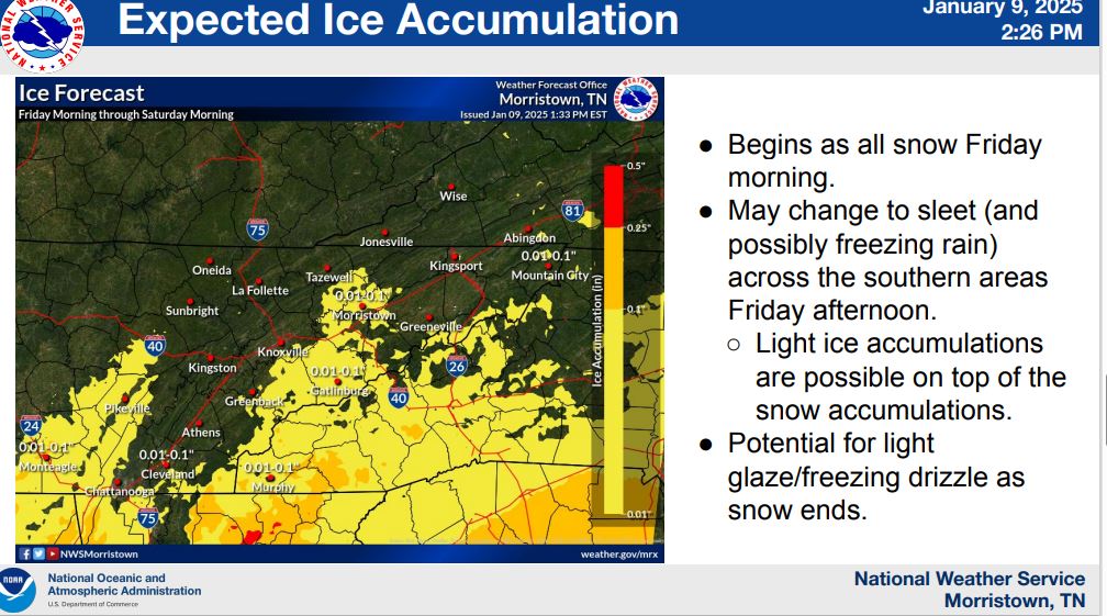
P-types
Temperatures will be cold Friday morning for snow most
definitely, but as we head into the afternoon, some warming to
possibilty above freezing in isolated spots and warm air aloft, may
make the precipitation types vary, cutting snow totals considerably.
This is evident in models and model soundings across the southern
tier of the forecast area and through the foothills part of the
Appalachians. Southerly flow and a tightening gradient will bring a
low-end mountain wave across the east Tennessee mountains. Between
21Z to 03Z time frame 40 to 50KT at least according to the NAM, will
dry things some between the valley and higher terrain. Warming due
to downsloping will also complicate things p-type and amount-wise.
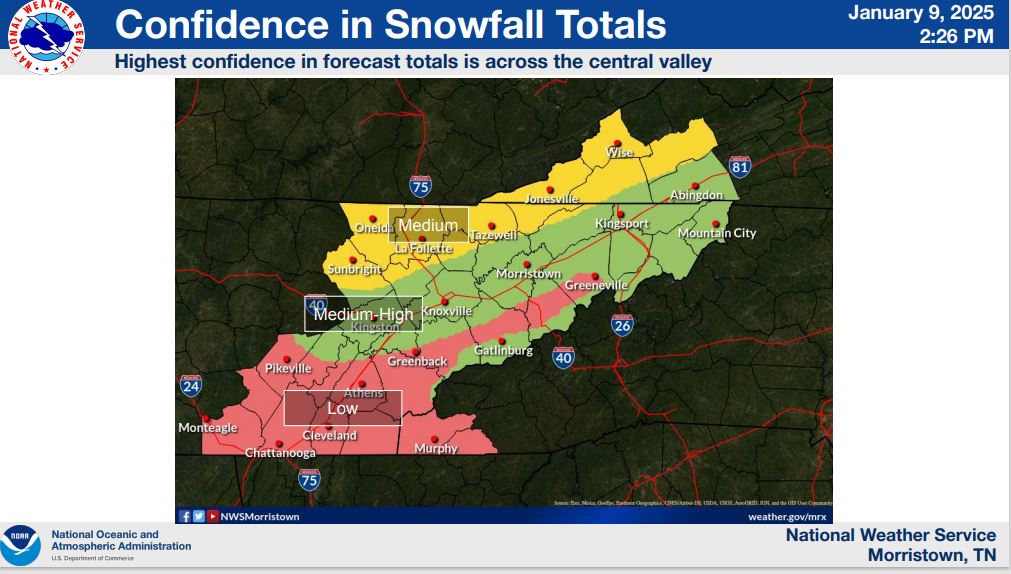
Due to all of this in mind, our confidence level on storm total
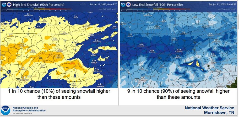
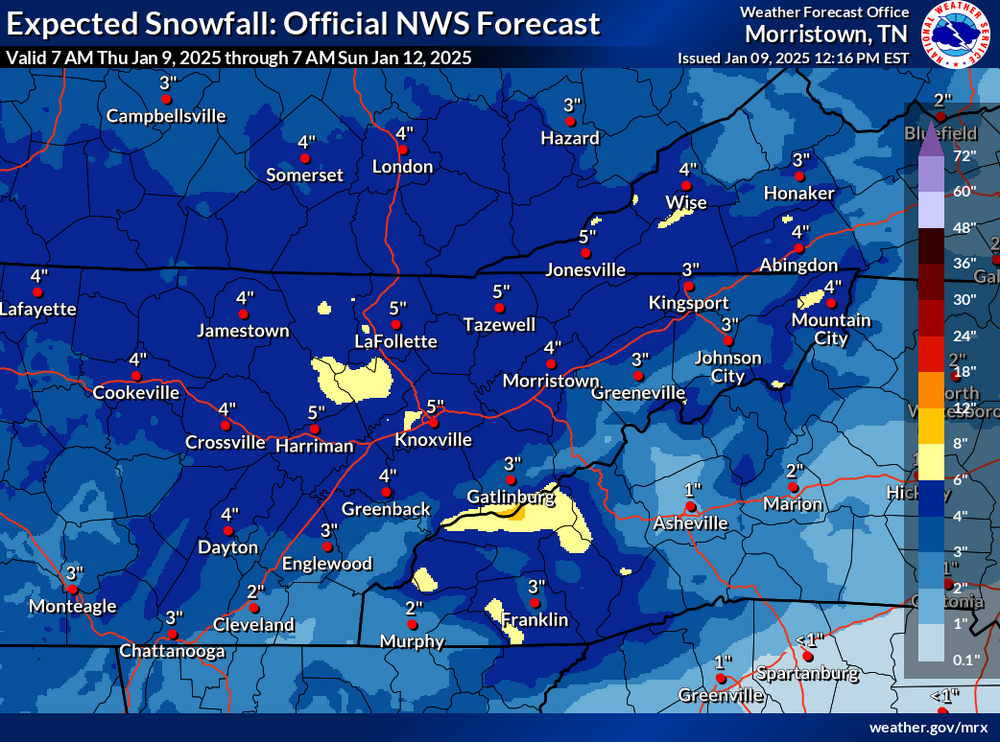
amounts is medium about 3 out of 5.
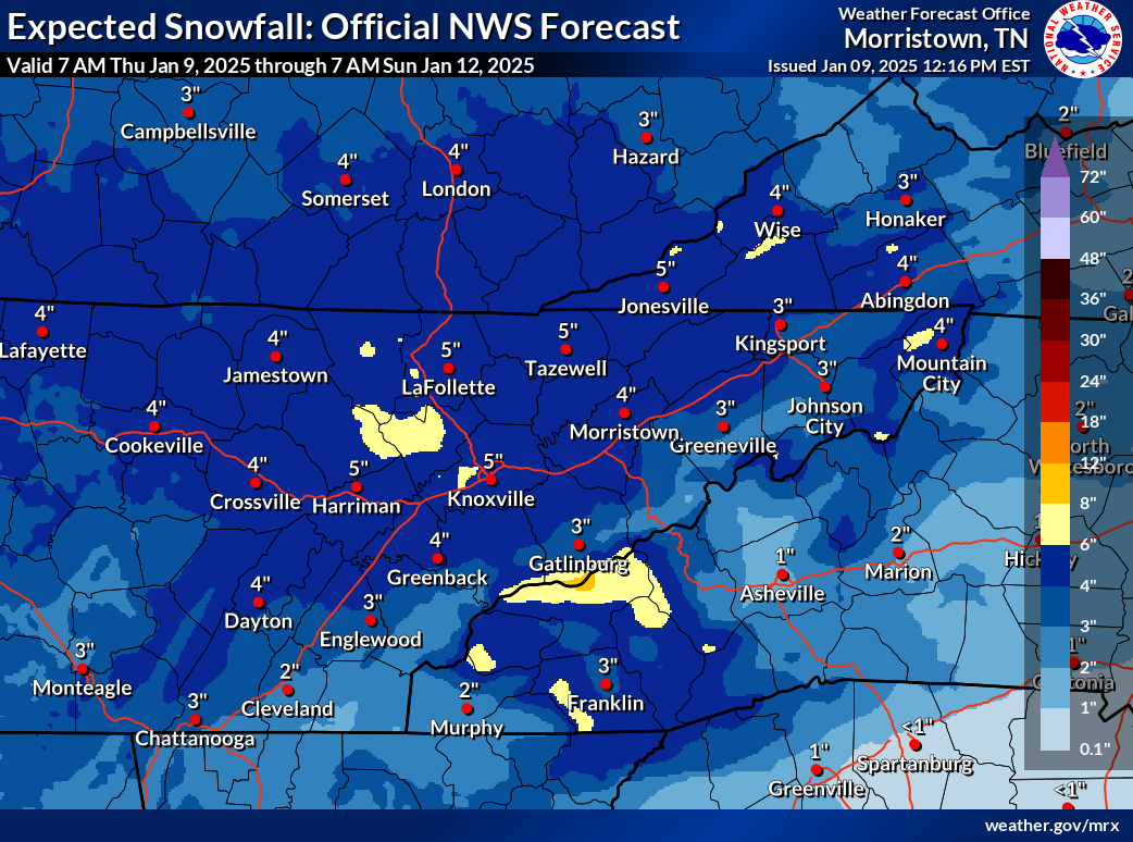
Snow
SLR`s will be about 10:1 and lower at the start of the event, so can
expect a wet and heavy snow. With time as things cool, SLR`s will
rise and can see the type of snow lighten some with less moisture.
Can expect the first reflectivities of snow between 6-8 AM EST, but
it may take a bit of time for the column to moisten and actually
reach the ground as RH`s down south are forecast to be around 60%
12Z Fri. Snowfall probabilities will increase from SW to NE
throughout the day Friday, reaching the Knoxville area by late
morning to noon, and early afternoon for far NE TN and SW VA. Our
latest storm total snow calls for the highest amounts (3 to 5 inch
range) to be expected north of I-40/west of I-81 so basically the
northern plateau. Higher elevations of the southern plateau and from
the Smoky`s south into SW NC may also see the greatest amounts. It`s
possible a gradient may form somewhere along I-40 north to I-81.
Snow will begin to taper SW to NE late Friday night into Saturday
morning, with snow possibilty continuing for the typical NW flow
higher terrain into early afternoon Saturday.
Temperatures
Temperatures may be impacted during and after the event as snowpack
can make surface temperatures much colder than what models can
depict. Edged lower with a blend of different guidances to bring
down temperatures during this time, as NBM may be too warm and not
be factoring in snow on the ground.
&&

 Same. Just praying it doesn't turn to sleet next.