

pasnownut
-
Posts
10,320 -
Joined
-
Last visited
Content Type
Profiles
Blogs
Forums
American Weather
Media Demo
Store
Gallery
Everything posted by pasnownut
-

The Ides of March end of Winter 2023
pasnownut replied to paweather's topic in Upstate New York/Pennsylvania
trout season opens Saturday silly -
The Ides of March end of Winter 2023
pasnownut replied to paweather's topic in Upstate New York/Pennsylvania
already growing, and many are mowing down here. Green up is well underway. -
The Ides of March end of Winter 2023
pasnownut replied to paweather's topic in Upstate New York/Pennsylvania
Yeah we see it. Same ones that bust others for winter talk. Cool summer would be nice. Don't do anything to Ruin it. In the infamous words of Bob Ross....think happy thoughts. -
The Ides of March end of Winter 2023
pasnownut replied to paweather's topic in Upstate New York/Pennsylvania
Glad you got to see some snow. You deserve it. Despite the beating you took in here, you are fully deserving. Hoping next year is a snow bonanza for you bud. Looks like north country has a white landscape this am as well. http://www.swedenhillsnocam.com/PCSC.jpg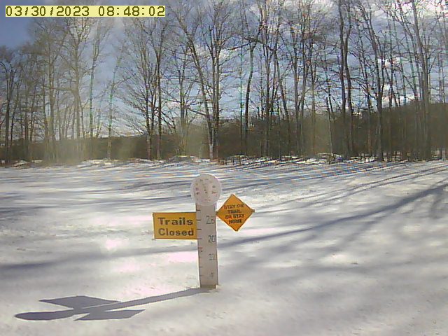
-
The Ides of March end of Winter 2023
pasnownut replied to paweather's topic in Upstate New York/Pennsylvania
No...youre not off at all. No met status needed to verify your statement. Happy Hump Day to you as well. -
The Ides of March end of Winter 2023
pasnownut replied to paweather's topic in Upstate New York/Pennsylvania
So...for the sake of disco, go to nooner GFS and look at the height lines. Then loop back a few runs. You'll see the 540s retreating and HP is no longer anchored and too far east. Then look to the west and see the big and all too familiar bulge pressing north. No reason for that to scoot off to the S coast w/ tellies progged as per my earlier disco. If you are correct, it'll be the NAO that would do it, but IMO it's not enough to hold things back w/ MJO losing amp at same timeframe, so likely it comes north. I'll say hello and give you a beer as I walk by you out on the weather limb. -
The Ides of March end of Winter 2023
pasnownut replied to paweather's topic in Upstate New York/Pennsylvania
Boone NC will take the snow... -
The Ides of March end of Winter 2023
pasnownut replied to paweather's topic in Upstate New York/Pennsylvania
Yeah, yesterday was a nice event for NE and the Poconos, but thats really not surprising (in a normal year). Cams looked meh yesterday afternoon, but hey it was something... for the 23rd event, AO looks to rise around that timestamp. NAO still neg, and MJO losing amp thru 1 would suggest to me that this one has a chance, as the boundary could come north. ENS guidance has varied looks at 500mb. One less pronounced trough and other showing ridging. My gut says another rainer down here w/ the normal elevations scoring. IF the look holds. My thoughts are really just based off current looks/guidance, and not much more than that. Quite frankly I'm about "wished" out for something to happen, but thought I'd throw my .02 in. -
The Ides of March end of Winter 2023
pasnownut replied to paweather's topic in Upstate New York/Pennsylvania
Yeah I saw that one. Good one to share. Its just surreal. -
The Ides of March end of Winter 2023
pasnownut replied to paweather's topic in Upstate New York/Pennsylvania
Been up since 330 and was watching youtube vids of Mammoth CA. Good grief. They wont see their mulch all year. peeps using 2nd story access to get in houses n stuff. Just a phenomenal stretch for them. -
The Ides of March end of Winter 2023
pasnownut replied to paweather's topic in Upstate New York/Pennsylvania
Yeah that off the chart 8 is impressive. No doubt. Just wished the Nina would've faded faster and we could have had a backend winter. I know I put too much faith in that happening, and it sure held on longer than expected. Yes, northers have been eeking their way back from the ledge and have had a few snows of late. Happy for them. As you suggest (and has been a fear of some of us), is that now that the rubber band snapped, were going to get all of that pent up cold when its really almost over for us (climo wise). Yes, we all know it can happen into easter, but like many others here, some of us just wanted snow in the air and otg for a while...even if only a little while. Not sure how many here have mentally moved on...but I know I have. Chalkin this one up as one of the bigger skunkers that I've witness in my years. Hoping next years Nino can work in our favor. Plenty of time to sort that out though. -
The Ides of March end of Winter 2023
pasnownut replied to paweather's topic in Upstate New York/Pennsylvania
I saw 15 seconds of flurries on way to work. Looks like a skiff of snow on roofs. #notwinningwhatsoever -
The Ides of March end of Winter 2023
pasnownut replied to paweather's topic in Upstate New York/Pennsylvania
Hey, you saw something and went after it, but like the other attempts at winter down here....it ALMOST worked...but didnt. Good on you for taking a stand. I've done it plenty here. -
The Ides of March end of Winter 2023
pasnownut replied to paweather's topic in Upstate New York/Pennsylvania
Yesterday someone said w/ in an hour of Lanco, there was a WSW. Looking at todays maps...you better take a lamborghini up 95 or 81 if youve got 60min to get to plowable snow from here. -
The Ides of March end of Winter 2023
pasnownut replied to paweather's topic in Upstate New York/Pennsylvania
Go pick your favorite go to model and loop through your beloved snowfall map outputs from the last 3-4 days. Like everything else this year, this one is slipping away. Yes, Poconos n points NE should get some fun, but the big stall/retrograde look, while still doing a single loop retro, is notably further NE and likely not what it was for the wester folks. -
The Ides of March end of Winter 2023
pasnownut replied to paweather's topic in Upstate New York/Pennsylvania
Looking over the tellies, this was likely the player in our current "winter" pattern. As you can see the notable swing thru 8 helped to get winter closer for some of us, but as you can see, its likely to head twds COD or lower amp 1/2. With that said, moving forward, the AO/PNA remaining much like they've been all winter, tells me that the NAO looking to once again head neg into next week, says much the same for us. NE may still get some late winter, but down here....close the friggin curtains already. Northern/western had a few events but bye and large, I'll be glad to put this mess behind me. For all that are still sniffin out the next one....enjoy the chase. -
The Ides of March end of Winter 2023
pasnownut replied to paweather's topic in Upstate New York/Pennsylvania
I had a nice weekend playing in the 3" around your area. -
The Ides of March end of Winter 2023
pasnownut replied to paweather's topic in Upstate New York/Pennsylvania
Its the part of the year I hate the most. Cant F'in wait. -
The Ides of March end of Winter 2023
pasnownut replied to paweather's topic in Upstate New York/Pennsylvania
northern 1/2 of state did a little better from this, but for us southers.....it was collosal....not epic and I wont be around to read about mow #54... -
The Ides of March end of Winter 2023
pasnownut replied to paweather's topic in Upstate New York/Pennsylvania
I'm not looking at radar. I'll still take my 6 and not 16'' "call" for NEPA. -
The Ides of March end of Winter 2023
pasnownut replied to paweather's topic in Upstate New York/Pennsylvania
well definitely for NEPA. Looks like they can take the 1 off the 16" -
The Ides of March end of Winter 2023
pasnownut replied to paweather's topic in Upstate New York/Pennsylvania
still think its one to watch. That may be YOUR storm pal, and even if it doesnt amount to much...it cold easily be our best event of the year down here. Feel better? -
The Ides of March end of Winter 2023
pasnownut replied to paweather's topic in Upstate New York/Pennsylvania
its rainin mashed taters here in Etown. or big soggy ass parachutes........... intermittent but its happening. -
The Ides of March end of Winter 2023
pasnownut replied to paweather's topic in Upstate New York/Pennsylvania
Look at how that 3rd slp pops off shore. Wont happen like that. Toss this nooner from the mix. What will happen....who knows, but not that. -
The Ides of March end of Winter 2023
pasnownut replied to paweather's topic in Upstate New York/Pennsylvania
wow... and we can get 1" F me

