

pasnownut
-
Posts
9,367 -
Joined
-
Last visited
Content Type
Profiles
Blogs
Forums
American Weather
Media Demo
Store
Gallery
Posts posted by pasnownut
-
-
5 minutes ago, Bubbler86 said:
The one thing about the GFS, it is literally something every day next week. Some are multi-day threats but 5 days straight of "stuff".
Yeah, but i'd rename it the "firehose" as we never really know what to expect.
Regarless, nice to see so many chances. Somethings gotta get us.
I know your not a big fan, but tellies are really better than "workable" for the extended. If we can pull off a decent Feb, I'd be fine w/ March comin in like a loin, and out like a lamb.
-
7 minutes ago, Bubbler86 said:
But said pants can be the tracking pants.
1 minute ago, Bubbler86 said:
consensus says....toss GFS, or compromise, and we get a good ol shellacking.
pants tent starting to take shape.
-
 1
1
-
-
Just now, Bubbler86 said:
Snowfall map shows how tight it was in the end
SLP/qpf didnt tick N, it triple jumped. Not gonna say toss it, but just add to the pile of solutions possible. Was notably further S in last 2 runs, so theres that.
-
1
-
-
Just now, Bubbler86 said:
Blizz is running through his Office right now...asking for anyone who has internet not filtered by Corp.
I'll add that there are notable SLP "adjustments" ongoing opp #4 for mid next week, so reminding all weenies to keep it in your pants, and just make tents for now.
-
 4
4
-
-
54 minutes ago, Bubbler86 said:
Icon prepping

nooner GFS is about to go whole hog at 174. Verbatim that has crowd pleaser written all over it.
-
lookin over overnighters, the parade of storms is about to commence.
Really excited to see how this all shakes out. Gonna be fun. If I could lock in the Euro, man o man, what a presentation that'd be
-
4
-
-
1 hour ago, paweather said:
Good GFS run
verbaitm, exciting times nontheless. We may not always be on the right side, but it's gonna b fun watchin.
-
1
-
-
1 hour ago, Itstrainingtime said:
Coating to 2" of sleet followed by up to .15" of freezing rain. (Elliott)
that .15 of zr would really pack r in tight. Holy shnikeys...
-
2
-
-
32 minutes ago, mitchnick said:
I like the looks of the Icon at the end of its run.
I'm not bothered by the GFS for next week, and I'm gonna say it....
right where we want it....for now. Arctic boundary shifted notably south.
-
37 minutes ago, GrandmasterB said:
Agree and I’m also noticing that the sleet accumulation maps have accums south of the M/D line which makes me think it will hang on even in southern PA for quite awhile.
Sounds like we look at the same thing in situ's like this, and why I look at "snow" maps, for that very reason, even if I've no idea what rendition of frozen is falling.
When they eek south, or hold, that's the sign us frozen lovers look for, and that CAD is doin its thingy...or not.
-
1
-
-
1 minute ago, Jns2183 said:
@MAG5035 had two great posts late night the last two nights that make me give credence to the sleet bomb angle above all.
Sent from my SM-G970U1 using Tapatalk
antecedent cold and how long it can hold w/ this CAD scenario makes me think things might just come in a smidge colder, and we all know in close situ's like this 1-2 deg's is a big difference. if one toggles through the 700/850's youll note that there is much more of a west (700's) and west to s/w at 850's component and no strong southerly fetch. Thats what i'm hangin my hat on anyways. Its gonna be a close one for us, but up in the Skook and points NE, I'd think they stay largely frozen at surface, even if its oh so shallow. the warmup is rather brief as well, and that 50's stuff looks largely gone for the easter folks. we may need some 40's to crack the ice a bit.
-
1 minute ago, anotherman said:
RGEM is a sleet bomb.
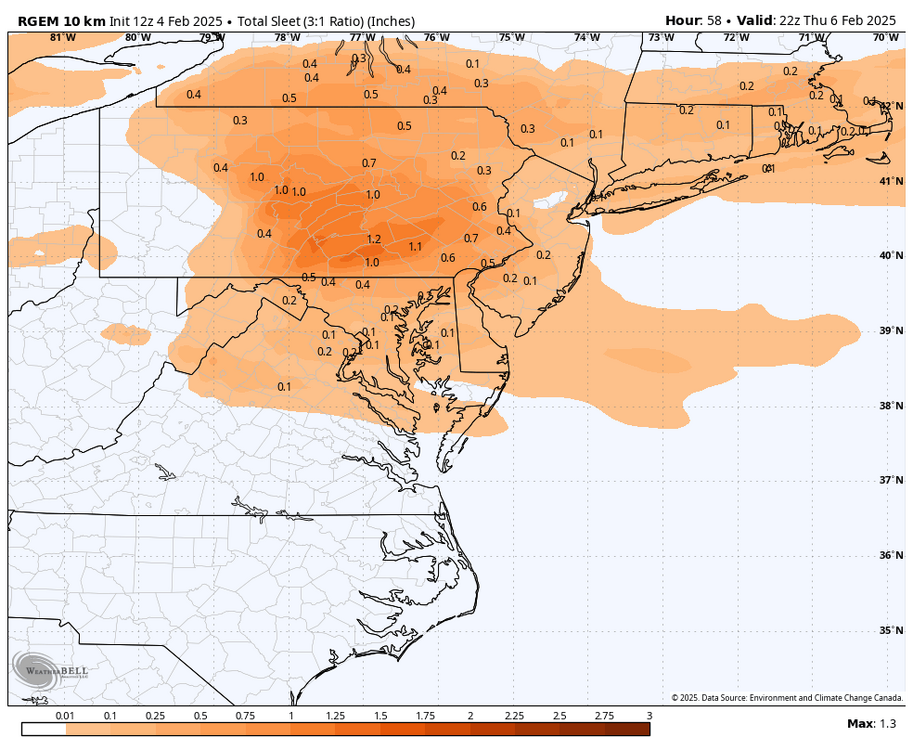
If 1/2 of that verifies, and you add some Zr to the mix....that might be a problem. Glad I brought some more wood down last night.
-
1
-
-
Ice
Ice
Babyall i've got to add to the disco....(see what i did there)?
-
2
-
-
1 hour ago, Jns2183 said:
24 hours ago my forecast high was 55. I made it to 43 today
Sent from my SM-G970U1 using Tapatalk
Yeah busted over here as well. I saw 45 on digi car thermo at 330. Forecast was for low 50’s. Cad baby.
-
1 hour ago, Bubbler86 said:
Below freezing about 850 and down during the GFS sleet storm

Looks pretty shallow to me. I’d wager zr with some pingers if qpf is stoudt enough. I’d like that freezing a little closer to the 700s for a pingerfest. Regardless looking icy for a bit.
-
1
-
-
17 minutes ago, Mount Joy Snowman said:
So true about the CAD routinely being under-modeled. I almost always assume it will hold stronger than depicted. More often than not, it's just so hard to fully scour away that boundary layer. GFS just came through with another nice hit for next Tuesday, albeit scaled back from prior runs.
Edit: And then it follows up with a more complex storm on Wednesday. Just complete tracking madness ha.
As I'm sure you know, it really is dependent on antecedent cold coupled w/ strength of SLP, and ability for WAA.
This one is coming from our WSW, an not up from the south. I pay attention to that because while were not really cold, the warm nose based on winds and weak SLP, may have a little tougher time scouring valleys as you get further east. Were it a strong southerly wind component, I'd think we'd lose 800/925's a bit quicker. That's just where my head is anyways, and why me thinks cold might be a bit tougher to scour. Gonna be really close tho.
-
 2
2
-
-
13 minutes ago, WmsptWx said:
Yeahhh I'd rather not have an ice storm.
While I love all things winter...I am no fan of a crippling one. Just a perty one, that is followed by cold and snow for the pertiest winter landscapes we can get.
-
2
-
-
When up in the Dack's this past weekend, I had a one on one w/ MO nature, and asked for some of that deep winter beauty to head south for us....
I made a deal with her, but can't tell you what I owe her in trade.
If she delivers....you're welcome in advance.

-
1
-
1
-
-
3 hours ago, Mount Joy Snowman said:
Low of 26 here with .1" of snow/sleet. Looks like a couple of ice storms to contend with on Thu/Sat. The best part of ice storms is getting to view all the wildly overdone pink model maps. What really has my attention is the middle of next week, quite intriguing. Fun tracking times ahead!
based on setup, its not a strong cad signal, but it is there, so icy lovers may get some fun. CAD is often undermodelled, so we'll see.
Yeah some of the snow maps for next week look crazy. If a third of that verified, I'd be happy....really happy.
-
3
-
-
Just now, pasnownut said:
With so/nao haeded into + territory that’s gonna b a big ask.
I’ll also add that the other day I suggested the cold may hold just long enough but feel that may b slipping away a bit. That’s why I’m headed to nny instead of n pa tomorrow.
-
56 minutes ago, Itstrainingtime said:
Need high pressure in a good location for us.
With so/nao haeded into + territory that’s gonna b a big ask.
-
1
-
-
and I'll add lastly, if we had a banter thread, I'd not have sift through the bullshit, but since we don't....please stop....or make your banter thread that i'll never read cause like it or not, your my weather pals...no matter what side of the F'd up fence you sit on.
Drops Mic....
-
1
-
-
1 hour ago, anotherman said:
Things are very messed up and I think the majority of people are clueless about how bad it is going to get (and already is).
I always chuckle when sides are formed, and attacks lobbed to the other side....that usually sits quietly and takes them. Its tiring...really.
Thats whats really sad IMO.
The rest is fearmongering, because both sides are F'd up......really bad and one side has to fix the others mess (that goes both ways).
To bad some cant/don't wanna see outta both sides of the glass.
My political post of the year is done. Back to weather.
Headed to Tug Hill tomorrow night. Havent been there for 17 years. Looking forward to feet of snow OTG.
-
1
-
-
8 minutes ago, Bubbler86 said:
The MA group needs to hire a counselor. LOL. This possibility was never really a flush snowstorm thing, we are racing against retreating cold just for something to track. The GEM is much different than the GFS which results in FRZ all the way down in GA. This is due, IMO opinion, to a broad ridge/upside down banana high to our NE vs. the GFS showing a SLP pushing the ridge East.
While I no longer head "down" into their sub.....(see what i did there), I can only imagine. I miss great convo w/ the normal good ones, but the rest was just too much for my sanity.
I've said it a bunch of times, as i've learned this long ago, in the infamous words of JB, what a model shows can only be considered, if it "fits the pattern". While I dont like what we just saw, technically it fits w/ NAO headed ++. NS forcing liftin out makes the wagons west scenario something to surely consider.
Just seems like the NS storm shredder/suppressor gets cut off really quick, and me thinks somethings amuck and as previously stated, IF it ejects a bit sooner, they they might be having something to hang their snow weenies onto. It could go the other way though. Just gotta see how strong n long the cold can hold. It can be stubborn to scour, and CAD is something that this potential event would have to work around.


Central PA Winter 2024/2025
in Upstate New York/Pennsylvania
Posted
merely an indicator of what a pattern might look like based on +/-'s of each tellie. As i've said many times, in the infamous words of Joe B....when looking at model runs...does it fit the pattern? That phrase has stuck w/ me for decades, and It has worked rather well overall from my amateur view, so I'll stick w/ it until something better comes around.
This years long lead calls, have been riddled w/ busts, and while I'm not judging whatsoever, we all have "our" bag of toys that we like pull from when makin guesses. Thats all. I'm checkin out for the afternoon, so go reel in the Euro in a bit and hook us a doozy