CentralNC
-
Posts
770 -
Joined
-
Last visited
Content Type
Profiles
Blogs
Forums
American Weather
Media Demo
Store
Gallery
Everything posted by CentralNC
-

February 18-19 MAJOR Ice Storm Threat
CentralNC replied to NorthHillsWx's topic in Southeastern States
Not sure a degree or two matters that much at this point in the piedmont but for fringe areas for sure. Still a lot of dry air draining down from VA. -
February 18-19 MAJOR Ice Storm Threat
CentralNC replied to NorthHillsWx's topic in Southeastern States
I was in the heart of that one. Was more of an in-situ damming situation and precip came just as the right time. There was literally no wind with that one. Still I lost power and lots of tree limbs. Was pretty bad by W-S standards. -
February 18-19 MAJOR Ice Storm Threat
CentralNC replied to NorthHillsWx's topic in Southeastern States
Just my opinion, but major roads will more than likely be just wet, but as it usually goes for me is people have trouble getting out of neighborhoods due to hazards. If it was me, I would cancel. -
February 18-19 MAJOR Ice Storm Threat
CentralNC replied to NorthHillsWx's topic in Southeastern States
Yeah should have said "only if it cools aloft too" !! -
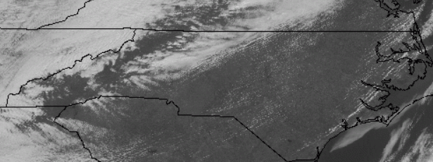
Most of the state in the sun....but not the triad.
-
February 18-19 MAJOR Ice Storm Threat
CentralNC replied to NorthHillsWx's topic in Southeastern States
I am still holding out (some) hope that sleet will save me at my location at least to some degree. But little doubt there will be a sizable chunk of real estate with ZR issues. Seeing models trend colder does not hurt my feelings one bit! -
February 18-19 MAJOR Ice Storm Threat
CentralNC replied to NorthHillsWx's topic in Southeastern States
You almost certainly will be in a Winter Storm Watch with the afternoon forecast packages. I don't think Surry escapes this one. -
February 18-19 MAJOR Ice Storm Threat
CentralNC replied to NorthHillsWx's topic in Southeastern States
Agree, GSO was 30-32 entire event and they got .25 in a lot of places. Key was it did not fall too fast allowing accrual. -
Here ya go.
-
I think Guilford will be the worst hit of the triad counties. Not that bad here in western Forsyth.
-
Not surprised. Prime location with continue low DP air filtering down from NVA.
-
Welcome aboard. We all suffer together...
-
I guess because Ice Storm Warning is so specific, maybe they wait until later packages to throw that one out there. You're a good candidate.
-
I agree 100%. I would think your area would be a bullseye for the most severe icing tonight and tomorrow.
-
Yeah I might be at the southern end of the main icing this go round. However, we now have teen DPs in NVA and it's still draining in this direction so you might come through with some icing with the round that's going through tonight.
-
Definitely a glazing of the trees here and had a bout of sleet overnight. Enough to whiten up the mulch and rooftops.
-
Sad but true.
-
Wow, GSP afternoon AFD not for the faint of heart if you want wintry precip. We just can't win.
-
At your location it would take some kind of anomalous system to make that happen. Always possible but I would not bet on it.
-
I feel ya. 1 winter storm warning and 3 advisories here for 1/2 inch of snow.
-
If there is not a decent HP over NY or PA, I'm not interested. Same old thing.
-
Finally switched to mostly snow in Lewisville at 12:15
-
Seriously? Still rain in Lewisville. Some snow mix but mostly rain.
-
Wow, nice pics. Wonder if that will ever make it to me....
-
Snow/rain mix in Lewisville