CentralNC
-
Posts
652 -
Joined
-
Last visited
Content Type
Profiles
Blogs
Forums
American Weather
Media Demo
Store
Gallery
Everything posted by CentralNC
-
My north side of house in the shade. I purposely shovel the driveway and sidewalk to make big piles that stay in the shade all day so the snow lasts the maximum number of days. I ain't right...also I'm 65 years old which makes it even worse
-
Snow ended. Ended up with a solid 2 inches from this system. Snowed continuously from around 6am to 10am, although the heaviest lasted about 1.5 hours. Crazy overperformer. More than yesterday ironically when we only picked up 1/2 inch. I'll take it!
-
Been snowing in Lewisville since before 6am and has just gotten heavier and heavier since this band has gone through. Overperformer for sure! No complaints!
-
Hope this band holds together

-
Flurries in Lewisville. These upper level systems rarely make it over the mountains. Maybe today will be an exception.
-
Hear, Hear. Congrats. Y'all have waited for a long time. ended up with 1/2 inch here. Nothing on roads.
-
We have about 1/2 inch here in Lewisville. Snowing to beat the band a short time ago (1pm) but now has slacked off quite a bit. 30 degrees
-
Don't think I have ever stated this, but BRING ON SPRING. I've had all the disappointment I can handle for one year.
-
must be a different part of Lewisville from me. -0- flakes for me since 5am.
-

February 19-20 Major Winter Storm Threat
CentralNC replied to NorthHillsWx's topic in Southeastern States
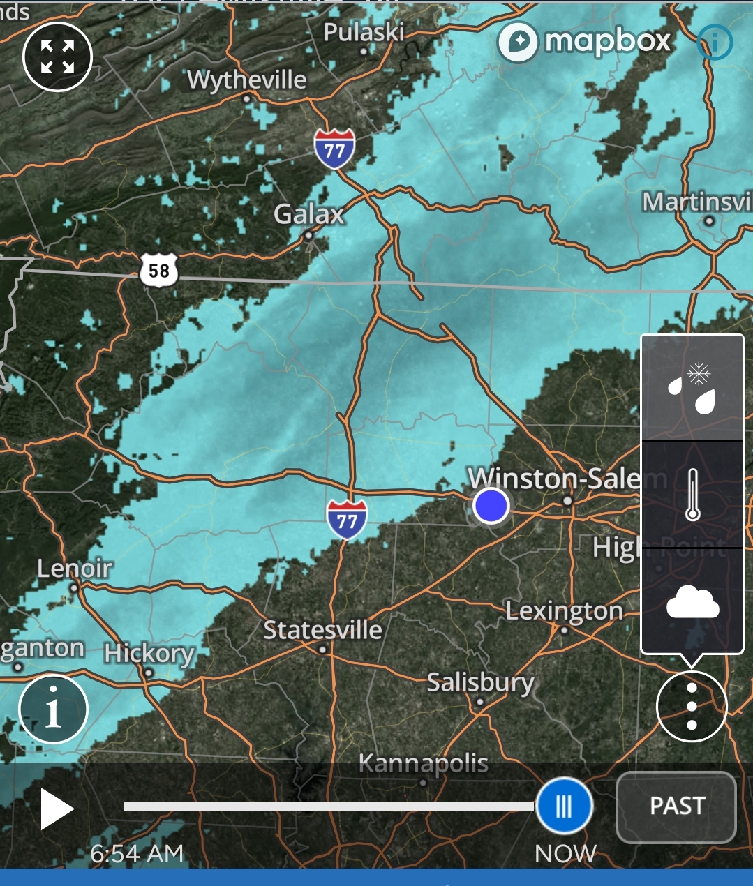
Based on radar trends I still think Raleigh area looks pretty good. In my neck of the woods, not so much. -
February 19-20 Major Winter Storm Threat
CentralNC replied to NorthHillsWx's topic in Southeastern States
Convection firing in the Gulf already. -
February 19-20 Major Winter Storm Threat
CentralNC replied to NorthHillsWx's topic in Southeastern States
Right there with ya -
Cranky off the top rope...the board would crash

-
February 19-20 Major Winter Storm Threat
CentralNC replied to NorthHillsWx's topic in Southeastern States
We got to have something to hold onto, don't we? -
February 19-20 Major Winter Storm Threat
CentralNC replied to NorthHillsWx's topic in Southeastern States
Maybe because they think it will be disruptive to travel since temps will be low for a lot of sticking, etc. I thought it was weird too. -
February 19-20 Major Winter Storm Threat
CentralNC replied to NorthHillsWx's topic in Southeastern States
Screw the model, I want to see it start getting together tomorrow when we are all nowcasting. -
February 19-20 Major Winter Storm Threat
CentralNC replied to NorthHillsWx's topic in Southeastern States
Thanks, but looks like I need to buy a ticket to the coast. -
February 19-20 Major Winter Storm Threat
CentralNC replied to NorthHillsWx's topic in Southeastern States
Saw the same thing. He does this virtually every time. -
February 19-20 Major Winter Storm Threat
CentralNC replied to NorthHillsWx's topic in Southeastern States
https://www.wpc.ncep.noaa.gov/discussions/hpcdiscussions.php?disc=qpfhsd Nice read on Heavy Snow discussion. The mention still the possibility of it climbing the coast. Still a lot of unknowns. -
February 19-20 Major Winter Storm Threat
CentralNC replied to NorthHillsWx's topic in Southeastern States
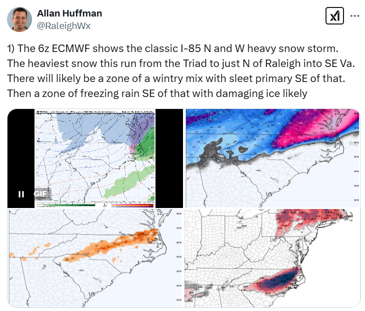
RAH discussion. They are seeing the same as everyone else on this board. We will all know either late Monday or early Tuesday. .LONG TERM /WEDNESDAY THROUGH SUNDAY/... As of 400 PM Sunday... A southern stream shortwave will move east from the southern Plains on Tuesday night to the Deep South on Wednesday, while a separate northern stream closed mid/upper low drifts SE from the Northern Plains to the Upper Great Lakes region. The southern wave and upper divergence from the right entrance region of an associated upper jet streak will spawn a surface low that develops on a cold front along the Gulf Coast on Tuesday night and early Wednesday. This low will then deepen and moves NE in a classic "Miller A" track along or just off the Southeast US coast on Wednesday afternoon and evening. With a cold dry air mass in place ahead of the system, confidence is increasing in a period of frozen precipitation across most of central NC from late Wednesday morning into Wednesday evening. However, how impactful it is still remains to be seen, with both precipitation types and amounts will very much up in the air. This does not look like an all snow event, as there is almost definitely going to be significant warming aloft with southerly flow at 850 mb. At this time, the most likely part of the region to stay all or mostly snow is the far northern Piedmont, with a fairly large corridor of mainly sleet and freezing rain to the south. Our southern tier of counties including FAY are most likely to stay all or mostly rain. A lot will depend on the degree of phasing that can occur between the southern stream and northern stream wave, the latter of which also has an associated jet streak which dives into the Central Plains and mid-MS Valley. The ECMWF (and to some degree the Canadian) has a faster and deeper northern stream mid/upper low compared to the GFS, allowing for stronger height falls and greater energy interaction between the two systems. This results in a deeper coastal low and would bring a high impact winter storm to central NC, with colder temperatures and greater QPF amounts. The GFS would be more of a moderate/nuisance type event that only lasts for 6-12 hours before we are quickly dryslotted after 00z Thursday. This is borne out in their respective ensembles as well, with the EPS ensembles depicting a 50+% probability of warning criteria snow (>= 3 inches) across roughly the northern half of the region while the GEFS only have 20-40% probabilities that are confined to our northern tier of counties. Deterministic and ensemble guidance has also been depicting potential for significant amounts of freezing rain somewhere across central NC, perhaps exceeding a quarter inch, with the greatest probabilities from around Raleigh to the south and east. The NAM is surprisingly the warmest out of all guidance, with mostly liquid for a good part of the area, but considering this storm is at the very end of its range, will mostly disregard it at this time. It should be noted that neither the GFS or ECMWF has complete phasing between the two waves, and the overall trend in both deterministic and ensemble guidance has been slightly downward in terms of overall QPF with a faster exit of precip, so will need to see if this trend continues. Yesterday the ensemble mean QPF was in the 1 to 2 inch range, while today it is more like the 0.5 to 1.5 inch range, lowest west and highest east. If this trend continues, we would be looking at more of a nuisance type event like the GFS has, but that is a big if. Stay tuned as details should become clearer, hopefully by tomorrow when the southern wave reaches the West Coast and we can get better sampling. As for timing, precipitation still looks to start from SW to NE on Wednesday morning, ending from SW to NE during the evening or early overnight hours. Temperatures will be highly dependent on the ultimate evolution of the system, but Wednesday is likely to be quite chilly with temperatures stuck in the lower-to-mid-30s during the day, maybe even upper-20s in the far north. Forecast lows Wednesday night are in the upper-teens to mid-20s. -
February 19-20 Major Winter Storm Threat
CentralNC replied to NorthHillsWx's topic in Southeastern States
I need that Low 50 miles closer to the coast! -
February 19-20 Major Winter Storm Threat
CentralNC replied to NorthHillsWx's topic in Southeastern States
I would not give up just yet, grasshopper. Still a ways to go on this one. Trend is not good but changes are probable. -
Thunder accompanying the front/rain. Temp jumped from 38 to 41 in the last few minutes.
-
February 19-20 Major Winter Storm Threat
CentralNC replied to NorthHillsWx's topic in Southeastern States
-
February 19-20 Major Winter Storm Threat
CentralNC replied to NorthHillsWx's topic in Southeastern States
Still has the Low in practically perfect position for Central NC, Central VA and SE VA snowstorm. I am not worrying too much about totals this far out.