

PWMan
-
Posts
1,308 -
Joined
-
Last visited
Content Type
Profiles
Blogs
Forums
American Weather
Media Demo
Store
Gallery
Everything posted by PWMan
-
The thing about these regional threads, especially in a gradient pattern, is that SOMEONE is always getting screwed and/or declaring a bust because radar looks crappy, the flakes don't look great, or their temp just spiked.
-
First few flakes, 31
-
Will be interesting to see our our school district handles this one, especially on the heels of snow days Friday and Monday. We're right on the line between a nuisance couple inches which - would be quickly washed away - and something more disruptive. And the timing is extremely tricky since the changeover's supposed to occur overnight (though that seems to keep getting a little earlier every time I look).
-
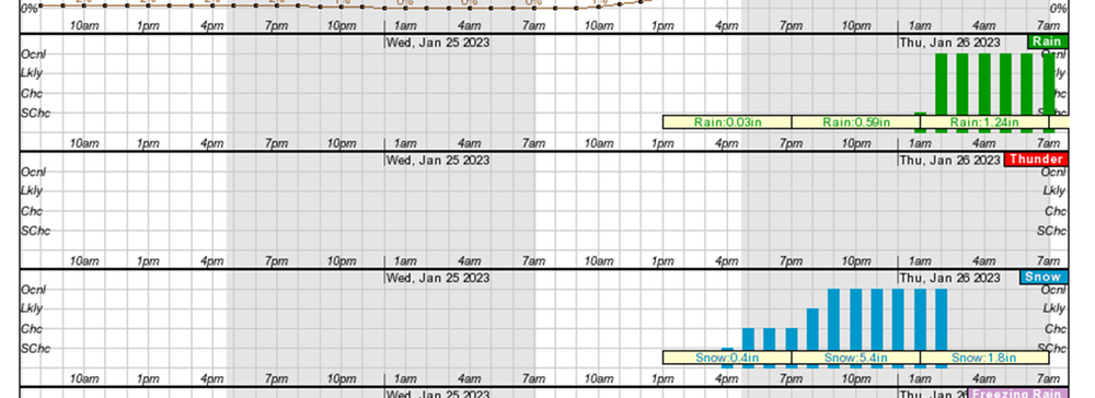
It's a dilemma for sure. I'm still hoping we're not actually going to see an inch+ of rain as depicted by the NWS hourly graphic product (as mentioned this morning). The GYX AFD and the text forecast make it sound like it'll be more showery in nature, but we'll see. I'm hoping I can at least hold serve if a net gain isn't in the cards.
-
Looking for new shades of purple and white to depict the high-end QPF.
-
I was looking at the NWS hourly forecast graphic below. Not sure how reliable those are for QPF by precip type. I'm certainly hoping this will be more of a thump-and-drizzle scenario.
-
I was thinking the same thing. Looks like the changeover here will happen at around 3:00 AM, so by the time I get up it's going to be a colossal mess. My P&C shows 5-9" of snow followed by over an inch of rain, and then the deep freeze.
-
Ended up with about 10", which is impressive considering the fact that we rotted in sleet and then a dry slot for several hours.
-
Trying to square the GYX snowfall map and P&C forecast with everything I’m seeing here + GYX’s own AFD, which talks about heavier snow at the coast based on trends.
-
Genug Shoyn Mit warm and brown! Is Jan 19-20 a storm to shift the vibe?
PWMan replied to mahk_webstah's topic in New England
Pleasantly surprised with how this one unfolded here given how borderline things seemed going into it. Went from tiny flakes to big aggregates at around midnight, and it dumped for a while. Just eyeballing things I'd say we're at 7-8". I'm always struck by how eerily quiet these blue bombs can be - every surface pasted, no wind. Looks like we're skirting the back end. Not expecting much more meaningful accumulation, but we'll see. -
Genug Shoyn Mit warm and brown! Is Jan 19-20 a storm to shift the vibe?
PWMan replied to mahk_webstah's topic in New England
Coming down at a pretty good clip now, and whitening up. 32 -
Genug Shoyn Mit warm and brown! Is Jan 19-20 a storm to shift the vibe?
PWMan replied to mahk_webstah's topic in New England
Light snow, 33 -
Genug Shoyn Mit warm and brown! Is Jan 19-20 a storm to shift the vibe?
PWMan replied to mahk_webstah's topic in New England
White rain, 36 -
Genug Shoyn Mit warm and brown! Is Jan 19-20 a storm to shift the vibe?
PWMan replied to mahk_webstah's topic in New England
Kids were assuming a snow day tomorrow. I’ll be shocked if we get 3 slushy inches. This feels like one of those where we waste a lot of precip on rain and non-accumulating snow. Hope I’m wrong. -
Genug Shoyn Mit warm and brown! Is Jan 19-20 a storm to shift the vibe?
PWMan replied to mahk_webstah's topic in New England
East - near Pine Point -
Genug Shoyn Mit warm and brown! Is Jan 19-20 a storm to shift the vibe?
PWMan replied to mahk_webstah's topic in New England
Light rain, 37 -
Genug Shoyn Mit warm and brown! Is Jan 19-20 a storm to shift the vibe?
PWMan replied to mahk_webstah's topic in New England
I know it's been said a million times, but it seems like it's been forever since we had a straightforward SWFE with a nice cold airmass to start and fairly uniform snow amounts across the region. Glad that the ski areas are getting some help. -
Genug Shoyn Mit warm and brown! Is Jan 19-20 a storm to shift the vibe?
PWMan replied to mahk_webstah's topic in New England
Brutal gradient around Portland as usual, and we're starting off pretty warm. I'm expecting maybe 3-4" of slop. -
If you want snow with every system you need to move to the Rockies or Sierras.
-
One thing that's remarkable about this pattern is that there's no real cold air anywhere in the lower 48. I'm heading out to southwestern Montana later this week for some skiing, and with a warm east coast I'd typically expect to see wintry conditions out there - but they'll be in the upper 30s and 40s for highs even at elevation. Fortunately they banked a decent amount of snow in November and December, and don't tend to get Grinchy storms that wash everything away.
-
Good stuff. I should clarify that I have had a couple days with a couple inches of cover, but with bare spots under trees. I’ve used my snowblower once. You had to be out early today since a lot of it vaporized once the sun came out. In any case, while I’ve appreciated what we’ve gotten it’s been paltry.
-
I haven’t had my grass fully covered yet. Saw kids today trying to sled in patchy shaded areas; reminded me of living in the southern mid-Atlantic.
-
Briefly lost power here. Internet down (Spectrum).
-
My P&C forecast is calling for a couple hours of snow after 10:00, though with the buzz-killing "little or no accumulation" caveat. I'm just glad it will all be out of here by Christmas Eve; hopefully we won't have to put real candles on the tree like in days of yore.
-
Preliminarily ... a medium impact partial Miller B, Friday
PWMan replied to Typhoon Tip's topic in New England
Pouring rain, 34


