mahk_webstah
-
Posts
11,845 -
Joined
-
Last visited
Content Type
Profiles
Blogs
Forums
American Weather
Media Demo
Store
Gallery
Everything posted by mahk_webstah
-

-

“Cory’s in NYC! Let’s HECS!” Feb. 22-24 Disco
mahk_webstah replied to TheSnowman's topic in New England
I hope you get in on it. I would think you’d be good for at least 10 inches. -
“Cory’s in NYC! Let’s HECS!” Feb. 22-24 Disco
mahk_webstah replied to TheSnowman's topic in New England
I’ll just say that while many things make me horny, a snowstorm is not one of those things -
“Cory’s in NYC! Let’s HECS!” Feb. 22-24 Disco
mahk_webstah replied to TheSnowman's topic in New England
I thought the euro AI looked a bit further south and east but who knows. Also, I’m not sure that’s the right model this close to game time. We just have to hope for the rogue band and a little push north. Zero would truly be laugh worthy. -
“Cory’s in NYC! Let’s HECS!” Feb. 22-24 Disco
mahk_webstah replied to TheSnowman's topic in New England
Messenger in the house -
On the euro AI March 5 also looks like a snowstorm with a low along or just off the coast.
-
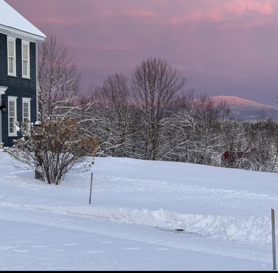
The view this morning is as spectacular of a view that I can remember here. Trying to attach a picture, but apparently the file size is too big.
-
I would think by Saturday even with settling, you should have a pack in excess of 3 feet. I might as well as I think I’m at 2 feet in the woods, although I haven’t been out for a few days. this really is a period to be savored and it’s totally cool that your son is into it with you! I’m hoping one of my little ones is a weenie. So far they go out in the snow and have a good time even when it was 2° and snowing a few weeks ago they’re outside walking around having fun.
-
Not up here and I think in a decent chunk of even southern New England away from the coast
-
"Don’t do it" 2026 Blizzard obs, updates and pictures.
mahk_webstah replied to Ginx snewx's topic in New England
Please just a little push north that doesn’t hurt any of you all down south, but gets a few more of us up here in the game. I think it’s a possibility. Strong storms like this do tend to push north a bit but then there’s also a brutal gradient. We all know this too well. -
Seems like this week coul bring a foot or a bit more to lower nne.
-
“Cory’s in NYC! Let’s HECS!” Feb. 22-24 Disco
mahk_webstah replied to TheSnowman's topic in New England
He’s my hero -
“Cory’s in NYC! Let’s HECS!” Feb. 22-24 Disco
mahk_webstah replied to TheSnowman's topic in New England
But you’re doing it, aren’t you? -
“Cory’s in NYC! Let’s HECS!” Feb. 22-24 Disco
mahk_webstah replied to TheSnowman's topic in New England
That seems fairly far north. Where does it go from there? -
“Cory’s in NYC! Let’s HECS!” Feb. 22-24 Disco
mahk_webstah replied to TheSnowman's topic in New England
I didn’t realize the differential between the pressures was so high. To me that would suggest winds gusting well past 70. -
“Cory’s in NYC! Let’s HECS!” Feb. 22-24 Disco
mahk_webstah replied to TheSnowman's topic in New England
How much does it give us? -
“Cory’s in NYC! Let’s HECS!” Feb. 22-24 Disco
mahk_webstah replied to TheSnowman's topic in New England
Hrrr moved a bit n so maybe that’s the next trend -
“Cory’s in NYC! Let’s HECS!” Feb. 22-24 Disco
mahk_webstah replied to TheSnowman's topic in New England
Hrrr gives a little hope for some decent bands up here. I consider 6” a win anywhere north of CON -
“Cory’s in NYC! Let’s HECS!” Feb. 22-24 Disco
mahk_webstah replied to TheSnowman's topic in New England
In what way -
Wednesday Wednesday night looks like light to moderate at least on the euro AI. But it’s not even next weekend for that larger storm. It’s Friday. This is a moderate to heavy storm for many, but no one’s really talking about it because of what’s happening tomorrow and Monday.
-
And the euro AI is right with it. 987 on Long Island to 994 in the Gulf of Maine. Temperature problems for parts of southern New England but it would make up for the impending disappointment up here and you guys would still be hung over anyhow.
-
“Cory’s in NYC! Let’s HECS!” Feb. 22-24 Disco
mahk_webstah replied to TheSnowman's topic in New England
the good news is there is 2 ft in the ground and good potential for the next week. -
“Cory’s in NYC! Let’s HECS!” Feb. 22-24 Disco
mahk_webstah replied to TheSnowman's topic in New England
Go. Plan in case power goes. -
“Cory’s in NYC! Let’s HECS!” Feb. 22-24 Disco
mahk_webstah replied to TheSnowman's topic in New England
Yes i’m in the five stages of grieving right now -
“Cory’s in NYC! Let’s HECS!” Feb. 22-24 Disco
mahk_webstah replied to TheSnowman's topic in New England
I felt bad for me