
Interstate
-
Posts
4,954 -
Joined
-
Last visited
Content Type
Profiles
Blogs
Forums
American Weather
Media Demo
Store
Gallery
Everything posted by Interstate
-
Yeah they have been playing lights out. Poole shot 16-32 for 50% and shot 4-17 from three point land. Maybe he should stop shooting 3s
-
I don’t believe so. Spacing is too far about.
-
You are welcome Wizards fans. Since I ragged on them, they have not lost. They just played the most amazing half of basketball.
-
This seems like a very quick mover... 6 Hours or less
-
3K NAM is pretty dry too ... spotty heavier areas of QPF
-
It does have one thing going against it... It coming in at midday though.
-
Yes I know I was a late on it... but no one actually posted the advisory other and a little screen shot on their phone.
-
WWA up for the Northern and Western counties URGENT - WINTER WEATHER MESSAGE National Weather Service Baltimore MD/Washington DC 935 AM EST Fri Feb 7 2025 MDZ005-006-503-505-507-VAZ506-526-072245- /O.NEW.KLWX.WW.Y.0007.250208T1700Z-250209T0500Z/ Carroll-Northern Baltimore-Northwest Montgomery-Northwest Howard- Northwest Harford-Eastern Loudoun-Northwest Prince William- 935 AM EST Fri Feb 7 2025 ...WINTER WEATHER ADVISORY IN EFFECT FROM NOON SATURDAY TO MIDNIGHT EST SATURDAY NIGHT... * WHAT...Mixed precipitation expected. Total snow and sleet accumulations up to one inch and ice accumulations around one tenth of an inch. * WHERE...Portions of central, north central, and northern Maryland and northern Virginia. * WHEN...From noon Saturday to midnight EST Saturday Night. * IMPACTS...Plan on slippery road conditions. * ADDITIONAL DETAILS...Precipitation is expected to overspread the area around noon on Saturday. Precipitation likely starts as snow before transitioning to sleet and eventually freezing rain through the afternoon. Precipitation will transition to rain late Saturday evening as temperatures warm.
-
Yep... It hits a wall right at the county line
-
It looks stronger on the H5 at 90
-
The heights are slightly lower on H81 H5 maps
-
You can blame @stormtracker for me... He brought up my profile yesterday and I just so happened to see when I joined. But I agree that the banter is getting out of hand in there. The one liners that mean nothing should be in banter. I try not to the muckj up the main threads with banter when we are actually tracking something. There are 3 or 4 bad ones in there that just post and bring nothing to the table.
-
Yeah... You cannot have a meltdown like that in the second half. Also, the foul shooting was horrible. Cannot give up freebies on the 1-1.
-
To be up by 17 with 3 minutes to go in the first half and lose like that... Lets see if they can bounce back. Also did you notice how the ref help MD out at the end by touching the ball when it was going out of bounds. It saved them a couple of tenths.
-
Yeah you cannot see it on LWX product because the Wind Advisory is showing.
-
Yeah I have no rain mentioned in my forecast until late Saturday night when it is ending.
-
Yep. Not suppose to get above freexing tomorrow. We are not relying on the wet bulb tomorrow.
-
How is KNTN (Martins Airport) reporting temp at 32 when everyone else around them are well into the 40s
-
If anyone wants to see the CMC in action. You might have to change the parameters to get the current run. https://collaboration.cmc.ec.gc.ca/cmc/cmdn/pcpn_type/pcpn_type_gem_reg.html
-
I know it is the wrong thread... but it might set the stage for the wave later in the week
-
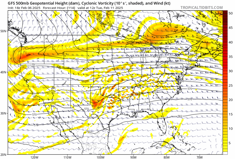
The H5 is much Flatter and the energy is being held back this run than the 18Z
-
and I was right with the 18Z... it was north of the 12Z... I am looking solely at the H5 maps.
-
H5 at 60 looks like it is going to be north to me.
-
Fucking horrible loss for MD
-
Why would I move. I finally got @North Balti Zen out of here. Lol


