

NavarreDon
-
Posts
2,890 -
Joined
-
Last visited
Content Type
Profiles
Blogs
Forums
American Weather
Media Demo
Store
Gallery
Everything posted by NavarreDon
-

2019 Atlantic Hurricane Season
NavarreDon replied to AfewUniversesBelowNormal's topic in Tropical Headquarters
Up to 40% for this little ditty. Not an expert but seems like lots of shear to deal with? . -
Awesome job keeping this thread updated HA, really appreciated!!! NHC leaning heavily towards the Euro & friends. Will be interesting to see what verifies.
-
The northern gulf is bath water! 85+ in almost all areas. Pensacola & Mobile are in line to shatter warm records for September. Mobile has or is forecast to have highs in the 90’s every day but one (89). It was warm last year before Michael but it’s been down right hot this September! Might not be relevant to Karen but if a system affects us it will definitely have ample fuel in the form of water temps. .
-
2019 Atlantic Hurricane Season
NavarreDon replied to AfewUniversesBelowNormal's topic in Tropical Headquarters
95L gets its cherry, 50% 2 day, 70% 5 day. . -
2019 Atlantic Hurricane Season
NavarreDon replied to AfewUniversesBelowNormal's topic in Tropical Headquarters
95L up to 60% on the 5 day 8:00 am NHC update. . ZCZC MIATWOAT ALL TTAA00 KNHC DDHHMM CCA Tropical Weather Outlook...Corrected NWS National Hurricane Center Miami FL 800 AM EDT Wed Sep 11 2019 Delete word and correct number For the North Atlantic...Caribbean Sea and the Gulf of Mexico: 1. Widespread cloudiness and showers extending from the southeastern Bahamas northward over the southwestern Atlantic for a few hundred miles are associated with a surface trough of low pressure. Limited development of this system is anticipated today or tomorrow, however conditions are forecast to become a little more favorable for development over the weekend, and a tropical depression could form as the disturbance moves slowly toward the west-northwest across the Florida Straits or South Florida and over the eastern Gulf of Mexico. Regardless of development, this disturbance could produce periods of locally heavy rainfall and gusty winds across the Bahamas through Thursday, and across Florida during the weekend. * Formation chance through 48 hours...low...20 percent. * Formation chance through 5 days...medium...60 percent. -
Delete if already posted. .
-
2019 Atlantic Hurricane Season
NavarreDon replied to AfewUniversesBelowNormal's topic in Tropical Headquarters
NHC down to 10% on 48hr and 5 day due to dry air & shear......sounds familiar for the N Gulf! . -
2019 Atlantic Hurricane Season
NavarreDon replied to AfewUniversesBelowNormal's topic in Tropical Headquarters
Nice call out on this. MOB talks about it in their morning short term: .SHORT TERM /Wednesday Through Thursday night/...A large upper trof extending from the eastern states into the north central Gulf steadily weakens during the period while an upper high remains anchored over the 4 Corners region. Another upper ridge over the western Atlantic gradually begins to build into the eastern Gulf meanwhile as the upper trof weakens. At the beginning of the period, a cold front will be located just off the mid Atlantic coast, across northern Florida, and extending westward across the northern Gulf. The frontal boundary lingers generally in place through Thursday night and gradually weakens. That said, there is the potential for a surface low to develop somewhere along the weakening frontal boundary, and this development would occur in a rather weakly sheared environment (generally <10 knots 1000-400 mb). While nearly all guidance shows no significant development of a surface low along the boundary, weak boundaries like this that stall in the Gulf within a weakly sheared environment have later on sometimes spawned tropical systems. For that reason, the National Hurricane Center has introduced a 20 percent chance of tropical cyclone development mainly within the time period beginning Thursday and lasting into Saturday. Note that this potential system is not associated with Tropical Depression Three, currently located between the Bahamas and the Florida peninsula, which is expected to meanwhile drift northward. For the forecast, have gone with mostly dry conditions through the period except for small pops near the coast and will need to closely monitor for the possibility of a system developing in the Gulf and how this might affect the area. Highs on Wednesday will be mostly in the upper 80s then around 90 on Thursday. Lows Wednesday night range from the mid 60s inland to around 70 at the coast, with a modest warming trend for Thursday night when lows range from the mid 60s well inland to the lower 70s closer to the coast. A low risk of rip currents is expected through the period. /29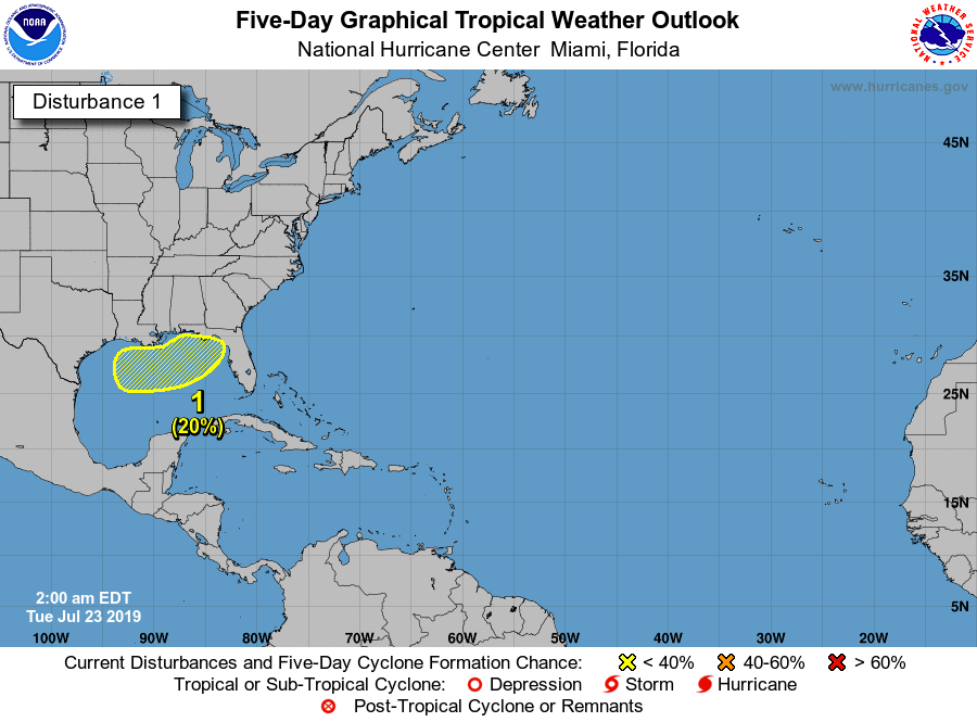
-
ZCZC MIATWOAT ALL TTAA00 KNHC DDHHMM Tropical Weather Outlook NWS National Hurricane Center Miami FL 200 PM EDT Mon Jul 22 2019 For the North Atlantic...Caribbean Sea and the Gulf of Mexico: 1. Showers and thunderstorms have increased in association with an area of low pressure located near Andros Island in the Bahamas. While environmental conditions are only marginally conducive for development, only a slight increase in the organization of this system could result in the formation of a tropical depression later today or tonight. Additional development is not anticipated after that time due to strong upper-level winds. The low is expected to move northwestward around 15 mph today and north-northwestward to northward tonight and Tuesday, remaining offshore of the east coast of the Florida peninsula. This system will continue to produce locally heavy rainfall and gusty winds over portions of the northwest Bahamas through tonight. Showers and thunderstorms could also spread over portions of the east coast of the Florida peninsula tonight and Tuesday. * Formation chance through 48 hours...medium...60 percent. * Formation chance through 5 days...medium...60 percent. Forecaster Pasch .
-
2019 Atlantic Hurricane Season
NavarreDon replied to AfewUniversesBelowNormal's topic in Tropical Headquarters
Anyone notice the 18Z GFS around hour 240ish? . -
2019 Atlantic Hurricane Season
NavarreDon replied to AfewUniversesBelowNormal's topic in Tropical Headquarters
8:00 am EDT NHC Tropical Weather Outlook NWS National Hurricane Center Miami FL 800 AM EDT Mon Jul 8 2019 For the North Atlantic...Caribbean Sea and the Gulf of Mexico: 1. A trough of low pressure located over central Georgia is forecast to move southward toward the northeastern Gulf of Mexico, where a broad area of low pressure is expected to form in a couple of days. Some gradual development is possible thereafter and a tropical depression is likely to form by the end of the week while the low meanders near the northern Gulf Coast. Regardless of development, this system has the potential to produce heavy rainfall along portions of the northern and eastern U.S. Gulf Coast later this week. For more information about the rainfall threat, please see products issued by your local weather forecast office and the NOAA Weather Prediction Center. Interests along the northern Gulf Coast and the Florida peninsula should monitor the progress of this system. * Formation chance through 48 hours...low...10 percent. * Formation chance through 5 days...high...80 percent. Forecaster Stewart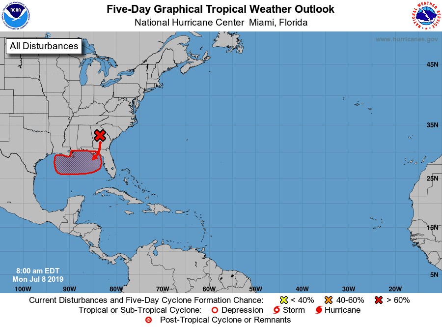
-
2019 Atlantic Hurricane Season
NavarreDon replied to AfewUniversesBelowNormal's topic in Tropical Headquarters
Saw this from the 12Z euro.... . -
2019 Atlantic Hurricane Season
NavarreDon replied to AfewUniversesBelowNormal's topic in Tropical Headquarters
NHC ups 5 day to 40% https://www.nhc.noaa.gov/gtwo.php?basin=atlc&fdays=5 -
2019 Atlantic Hurricane Season
NavarreDon replied to AfewUniversesBelowNormal's topic in Tropical Headquarters
TAE has this graphic on their homepage basically picturing what Windspeed is saying above. . -
2019 Atlantic Hurricane Season
NavarreDon replied to AfewUniversesBelowNormal's topic in Tropical Headquarters
Obviously keeping a close eye on this. So many variables but a possibility. At work still, has there been any consistency with today’s model runs? . -
I realize we're all big boys & girls with the capability to find it own our own but the ST disco from GSP is well......simply stunning! It needs to be posted for posterity. Even a mention of the B word! .SHORT TERM /FRIDAY NIGHT THROUGH MONDAY/... As of 355 AM EST Thursday: High confidence that a nearly ideal synoptic set up for widespread and significant winter weather will commence across the forecast area this weekend and possibly continue into early next week. The highest in significant winter weather is placed across the mountains foothills and NC Piedmont along and north of I-40 where snow is expected to be the dominant precipitation type, although periods of sleet and freezing rain are also likely, especially outside of the mountains. Moderate confidence for significant winter weather exists in the SC/NC Piedmont along and north of I-85 and south of I-40 mainly east of I- 25. South of I-85 is not out of the woods with periods of moderate to heavy ice and/or snow possible, but rain is expected to mix in most often here, likely limiting ice/snow accumulations and related impacts. The expected overall synoptic setup has not really changed much for several days, although model guidance has fairly uniformly tracked track of the winter storm a bit further south and therefore leading to snow and mixed precip types becoming more likely a bit further south. A key to the upcoming winter storm is that cold air will be locked in place across the region as confluence aloft ahead of the system maintains a 1030+ mb W-E elongated sfc high pressure system to our north with cold air damming (CAD) persisting through most of the event. Good model consensus shows sfc low pressure riding along the fringe of the strong high, initially along the Gulf Coast Saturday before riding along or just off the Southeast Coastline while intensifying Sunday. This setup will bring light to moderate precip overspreading much of the sometime Saturday afternoon or evening before becoming heavy at times overnight into Sunday. The latest NAM indicates very dry air courtesy of the CAD possibly delaying precip onset, especially across NC foothills, Piedmont and northern mountains. A strong low level jet of 40+ kt is expected to push through the region Sunday bring breezy conditions to many location and gusty winds to the mountains above 3K or 4K feet where wind gusts in excess of 40 mph are likely. This combined with period of heavy snow may support at least brief blizzard conditions, especially across east facing mountains. The strong low level jet will also support an elevated (700-800mb), but now somewhat cooler warm nose which will likely increase the icing threat which model guidance and climatology would suggest would change somewhere between the I-85 and I-40 corridors, lasting at least 3-6 hours. The timing of the change over is likely sometime late Sunday night though early evening and would like be limited across the mountains, although sleet and freezing rain may mix in at times during this period, especially south of I-40. The CAD will likely gradually dissipate late Sunday into Monday but be replaced by cold air filtering in behind the storm. Any ice should be large over during this time with snow the predominate type area-wide, except during the afternoon when rain may mix in at times outside of the mountains mainly into the Upstate of SC and northeast GA. A deformation zone with banding precip is possible during this time, but there is still some uncertainly where exactly sets up and how much precipitation we may see. The bottom line is the additional snow is possible just about anywhere during this time. Melted snow/ice or liquid precip storm total amounts continue to be around 2 inches across most of the forecast area with local amounts approaching 3 inches possible south of I-85 and across higher east facing mountains due to upslope enhancement. Early estimates continue to place snow amounts between 10 and 20 inches across the mountains, foothills Piedmont northwest of I-85. Local 20+ amounts are possible across higher east facing mountain and foothill locations. Dangerous freezing rain and sleet accumulations in excess of one half an inch continue to be possible with the high totals and therefore impacts between I-85 and I-40 outside of the mountains. Although latest model trends suggest areas closer to I-85 might have the most cause for concern. the bottom line is that a potentially very dangerous winter storm looms for much of the forecast area this weekend. And as the day shift yesterday put it, this could be a once-in-a-generation event for areas that experience mostly snow and ice. Now is the time to prepare. Finish preparations by Friday as if this storm speeds up Saturday may be too late, especially for the Upstate of SC into northeast GA.
-
Here is some thoughts from the MOB office on where they currently think the surface low is headed thru their FA. This will pertain more to the Upstate SC & WNC crew. It might be worth the read for you guys up north. Down here I have to wonder if we will ever dry out! LONG TERM /Friday Through Monday/...Another mild day expected Friday with daytime high temperatures climbing into upper 50s to lower 60s...within a few degrees of seasonal norms. Easterly surface winds will gradually strengthen during the afternoon and become southeasterly in response to an approaching low pressure system to our west. By Saturday night, an eastward propagating cold front is projected over the Western Gulf with a surface low just offshore of the Southwest Louisiana and Texas border with a warm front extending eastward across the Northern Gulf. There still remains a lot of variability between the models on the evolution of this system as well as its timing. Have trended this forecast package more towards the GFS and UKMET solutions of keeping the surface low and attendant warm front generally along the coast as if moves east, but did address the potential for more convection inland with increased PoPs and isolated thunderstorms due to the more northerly track advertised by the ECMWF, GEM and some of the GFS ensemble members. It currently looks like the best chance of precipitation will occur Saturday afternoon through Saturday night with rainfall amounts heaviest closer to the coast where forcing for ascent will be strongest and precipitable water amounts will approach two inches. Rainfall amounts of 2 to 4 inches appear possible at this time along the coast tapering off to 1 to 2 inches inland. Indications are this system will be relatively fast moving so not anticipating widespread flooding but localized flooding will remain possible. Another critical concern is whether or not the warm sector shifts inland if it does, this could lead to strong to possibly severe thunderstorms especially along the coastal counties of Alabama and the Western Florida Panhandle. We will continue to monitor trends and adjust accordingly. For now, continued with the previous thinking of the surface low moving east along the coast with most of the surface based instability remaining offshore.
-
Southeast Sanitarium - A Place to Vent
NavarreDon replied to Jonathan's topic in Southeastern States
Hahahahaha! Miss the snow but not the nonsense. On the bright side you only have around 90hrs to go! -
Congrats fellas! Hope the new forum works well for you all.
-
Devastating tornado strikes Joplin, Missouri
NavarreDon replied to Hoosier's topic in Weather Forecasting and Discussion
Your blog was tweeted by someone I follow & I read it there. Great write up. My Mom said it was a fairly somber day in Joplin yesterday. (heightened by the events in Moore I'm sure) After moving there from the Ft Lauderdale area. She is more certain than ever she will spend the rest of her life in Joplin. The will of the people there along with the kindness just over whelm her. She had to stop by Wal Mart yesterday & a random group of people where collecting the same supplies JoMo spoke about to send to Moore. She pitched in and did her part & then just broke down. When I talked to her last night she was just astounded by the acts of the people in the Midwest. -
Devastating tornado strikes Joplin, Missouri
NavarreDon replied to Hoosier's topic in Weather Forecasting and Discussion
NWS-SGF marks the 2 year anniversary of the Joplin Tornado with a summary of the events. http://www.crh.noaa.gov/sgf/?n=event_2011may22_summary -
Historic Tornado Outbreak April 27, 2011
NavarreDon replied to CUmet's topic in Weather Forecasting and Discussion
Found this on my computer.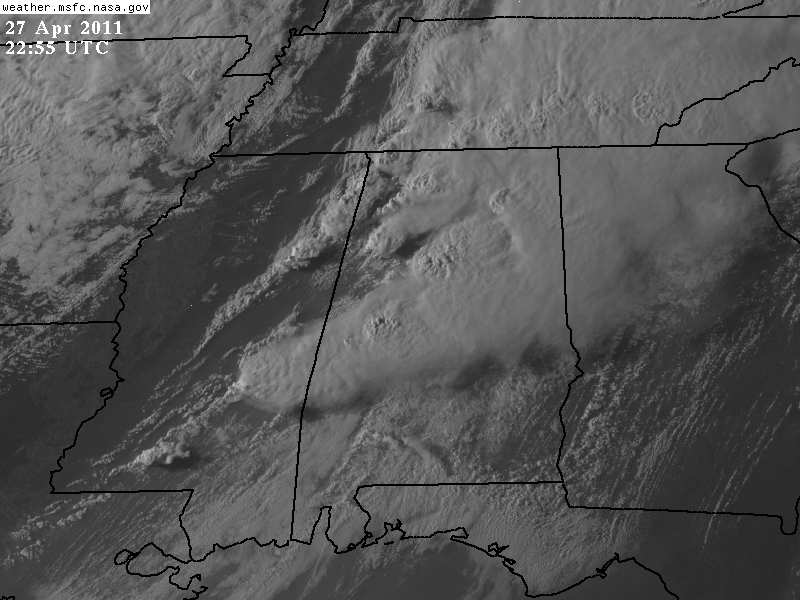
-
Devastating tornado strikes Joplin, Missouri
NavarreDon replied to Hoosier's topic in Weather Forecasting and Discussion
Hey JoMo, Just wanted to say Merry Christmas to you & all the people of Joplin. I talked to my Mom last night & she just broke down. She said the will and fortitude of the people is just so overwhelming. Every time she starts to feel sorry for herself she hops in her car and drives around town. She has lived in Joplin for about 2 years now and she says she will never leave because of the people. Bless you all & may this coming year be one of more rebuilding and healing. -
Weather References and Newbie Information
NavarreDon replied to burgertime's topic in Southeastern States
Awesome thread! Not just for the newbies, but for everyone. I would add these 2 links to the RUC & the HRRR for when it's go time. Great job Burger. http://www.twisterdata.com/index.php?prog=forecast&model=RUC&grid=255&model_yyyy=2011&model_mm=11&model_dd=16&model_init_hh=13&fhour=00¶meter=TMPF&level=2&unit=M_ABOVE_GROUND&maximize=n&mode=singlemap&sounding=n&output=image&view=large&archive=false http://rapidrefresh.noaa.gov/hrrrconus/ -
Tornados count relationship to hurricanes in NC
NavarreDon replied to downeastnc's topic in Southeastern States
Nice find & impressive work. Props to you and Shaggy


