

NavarreDon
-
Posts
2,890 -
Joined
-
Last visited
Content Type
Profiles
Blogs
Forums
American Weather
Media Demo
Store
Gallery
Everything posted by NavarreDon
-

2019/2020 Mountains and Foothills Fall/Winter Thread.
NavarreDon replied to Tyler Penland's topic in Southeastern States
Hello Mnt & Foothill peeps! I see we’re in the pre storm boom or bust excitement phase. I really like the look of this system. In GSP’s afternoon disco they speak of the system currently in Texas being better organized than modeled. Certainly won’t be surprised to see some places upgraded overnight. As usual there will be over & under performers. Enjoy the now though because it’s a big part of the fun! Good luck to all of you. . -
.
-
Wind and storms are ripping onshore from the gulf down here in the Panhandle. Tons of energy & fuel for you guys upstream. Be safe & alert today! .
-
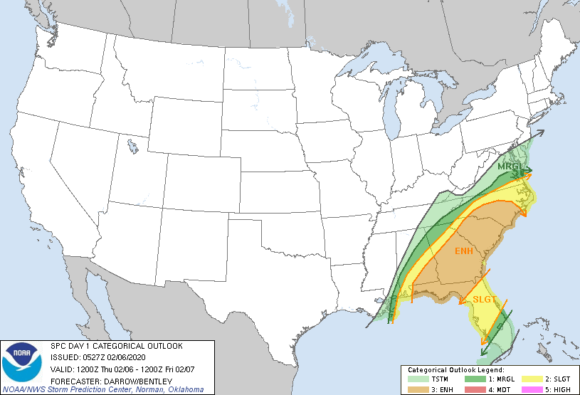
Surprised this isn't getting more attention: Day 1 Convective Outlook NWS Storm Prediction Center Norman OK 1127 PM CST Wed Feb 05 2020 Valid 061200Z - 071200Z ...THERE IS AN ENHANCED RISK OF SEVERE THUNDERSTORMS FROM THE FLORIDA PANHANDLE TO NORTH CAROLINA... ...SUMMARY... Severe thunderstorms are expected to spread from the northeast Gulf Coast this morning to the Carolinas by early evening. Damaging winds could be common with this activity, and a few tornadoes are also possible. ...Northeast Gulf Coast to the Carolinas... Strong low-latitude trough is beginning to shift east across the Big Bend of TX/northeast Mexico as a pronounced mid-level speed max approaches the base of this feature. By mid day, 500mb speed max in excess of 100kt will translate into the lower MS Valley, then strengthen to near 140kt over the Carolinas by 27/12z. In response, intense 12hr mid-level height falls (200m) will spread across the northern Gulf States into the western Carolinas. LLJ is forecast to strengthen across the northern Gulf Basin into southern AL by sunrise Thursday. This will encourage boundary-layer moistening with upper 60s surface dew points expected to advance inland across southern AL/GA, with near 70F dew points across the FL Panhandle. This moistening will be more than adequate for substantial SBCAPE ahead of the surging cold front. Latest thinking is scattered-numerous thunderstorms will be ongoing along the front at the start of the period. As large-scale forcing approaches this region, a sharpening band of frontal convection should evolve. Given the strengthening wind fields there is increasing confidence that a potentially damaging squall line will race northeast across the ENH Risk area. In addition, a few pre-squall line supercells may also develop as minimal forcing will be needed to initiate convection. Tornado threat will be most concentrated with these more discrete structures, though embedded squall-line circulations are also expected given the shear. A well organized squall line should progress across GA/northern FL into the Carolinas during the evening hours. This linear MCS should advance off the NC Coast shortly after midnight. ..Darrow/Bentley.. 02/06/2020
-
2019/2020 Mountains and Foothills Fall/Winter Thread.
NavarreDon replied to Tyler Penland's topic in Southeastern States
. -
MOB with a great disco on our area down here! https://forecast.weather.gov/product.php?site=MOB&issuedby=MOB&product=AFD&format=CI&version=1&glossary=1 .
-
Thoughts? https://www.spc.noaa.gov/products/outlook/day3otlk.html
-
2019 Atlantic Hurricane Season
NavarreDon replied to AfewUniversesBelowNormal's topic in Tropical Headquarters
Hold on!!! Tropical Weather Outlook NWS National Hurricane Center Miami FL 700 AM EST Tue Nov 19 2019 For the North Atlantic...Caribbean Sea and the Gulf of Mexico: 1. A broad area of low pressure located about 250 miles northeast of the northern Leeward Islands is gradually becoming better organized and the associated shower and thunderstorm activity has been developing closer to the center since yesterday. If this trend continues, then a tropical or subtropical depression or storm could form in the next day or so while the system moves northwestward and then northward over the open Atlantic. The low is forecast to interact with a frontal system by midweek and further development is unlikely after that time. For more information, see High Seas Forecasts issued by the National Weather Service. * Formation chance through 48 hours...high...80 percent. * Formation chance through 5 days...high...80 percent.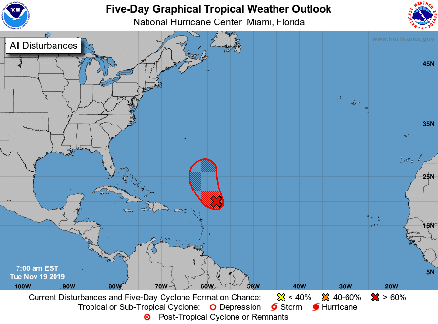
-
Duh!!! Thank you. .
-
I’m sure this is going to sound stupid but...why no update since 10? .
-
Nice write up by MOB on the tornado threat. Area Forecast Discussion...UPDATED National Weather Service Mobile AL 1111 AM CDT Fri Oct 25 2019 .DISCUSSION...See updated information for land and marine areas below. && .UPDATE...A complicated synoptic pattern exists over the local area. First off, a warm front was draped from off the Louisiana coast up across the MS Sound, east northeast to the I-10 corridor over the northwest FL Panhandle. Tornado watch is in effect thru 4 pm this afternoon over the western half of the local area. A brief discussion on notable late AM mesoscale analysis data shows bulk shear magnitudes 35 to 50 kts from the MS sound northward over the watch area. Co-located with this area, 0-1km storm relative helicity values range from 200-300 m2/s2 mostly north of the warm front, while the highest instability resides south of the warm front where a strong gradient of mixed layer capes of 1000-2000 J/KG is positioned from the coast, southward out over the marine area. Along the warm front and the strongly backed low level flow, there is an increased potential for any updrafts lifting up off the Gulf and across the coast to stretch and tighten as cells approach and move across the boundary where the low level helicity begins to increase. Tornadoes can spin up quickly in this environment. Tropical depression 17 has formed over the southwest Gulf and the expectation is that as this feature gains latitude, it will merge with a cold front approaching slowly from the west and transition into a post-tropical cyclone. No coastal tropical hazards at this time due to the expected transition, but may result in the necessity of the issuance of a gale warning over portions of the marine area and perhaps a high surf warning. That decision will be made this afternoon. Heavy rain threat continues. No changes made to flash flood watches. High risk of dangerous to potentially deadly rip currents continues. /10 .
-
Tornado warning for Harrison county MS. .
-
Pretty tight cluster! .
-
2019 Atlantic Hurricane Season
NavarreDon replied to AfewUniversesBelowNormal's topic in Tropical Headquarters
Advisories forthcoming Tropical Weather Discussion ZCZC MIATWOAT ALL TTAA00 KNHC DDHHMM Special Tropical Weather Outlook NWS National Hurricane Center Miami FL 945 AM EDT Fri Oct 25 2019 For the North Atlantic...Caribbean Sea and the Gulf of Mexico: Special outlook issued to update discussion of systems in the Gulf of Mexico and southwest of the Azores. 1. Updated: Visible satellite imagery and surface observations indicate that a tropical cyclone is forming in the western Gulf of Mexico, and advisories will be initiated on this system later this morning. The system is forecast to merge with a cold front and become post- tropical tonight over the northwestern Gulf of Mexico. Gale-force winds are expected behind the cold front over the western Gulf of Mexico today and Saturday. For more information, see High Seas Forecasts issued by the National Weather Service. An Air Force Reserve Hurricane Hunter aircraft is scheduled to investigate the system later today. * Formation chance through 48 hours...high...near 100 percent. * Formation chance through 5 days...high...near 100 percent. . -
2019 Atlantic Hurricane Season
NavarreDon replied to AfewUniversesBelowNormal's topic in Tropical Headquarters
97L gets it cherry on the 8:00pm. . -
2019 Atlantic Hurricane Season
NavarreDon replied to AfewUniversesBelowNormal's topic in Tropical Headquarters
Interesting solution by the 18Z GFS hours 30-42! . -
2019 Atlantic Hurricane Season
NavarreDon replied to AfewUniversesBelowNormal's topic in Tropical Headquarters
Up to 60% on the 2pm NHC outlook. . -
2019 Atlantic Hurricane Season
NavarreDon replied to AfewUniversesBelowNormal's topic in Tropical Headquarters
Watching this one closely from Navarre! -
2019 Atlantic Hurricane Season
NavarreDon replied to AfewUniversesBelowNormal's topic in Tropical Headquarters
Not only likely but, the euro had been showing a LA landfall until the latest run. This is from MOB's overnight. Global spectral models are in general agreement projecting the upper level trough currently moving eastward over west Texas to essentially interact with the disturbance and rapidly advance it northeastward over the Gulf. This system is likely to become increasingly baroclinic in nature before reaching the northern Gulf Coast and remain a hybrid type system. The models do vary in the eventual track and timing of the system. With the ECMWF now projecting the low moving onshore east of Destin, Florida Saturday morning and the GFS near Port St. Joe, Florida. Keep in mind though there still remains a great deal of uncertainty in the eventual track as the disturbance has still not developed a low level center...so inherently there will be more error at this point in the model tracks, and the model forecast will undoubtedly change as the system develops. Also, since this system is expected to evolve into more of hybrid/baroclinic system the rain and wind impacts will possibly extend far from the center. -
2019 Atlantic Hurricane Season
NavarreDon replied to AfewUniversesBelowNormal's topic in Tropical Headquarters
Tropical Weather Outlook NWS National Hurricane Center Miami FL 200 AM EDT Thu Oct 17 2019 For the North Atlantic...Caribbean Sea and the Gulf of Mexico: 1. Showers and thunderstorms associated with a broad area of low pressure located over the Bay of Campeche have increased and become a little better organized during the past several hours. Recent satellite wind data also indicate that the system is producing winds to near tropical storm force. Environmental conditions are expected to be conducive for additional development, and a tropical or subtropical storm is likely to form later today or tonight while the system moves generally northeastward over the western Gulf of Mexico. The low is forecast to approach the northern or northeastern Gulf Coast on Friday or Saturday and regardless of development, the system is likely to produce gusty winds and rough surf over those areas. Heavy rainfall is also possible across portions of the southeast U.S. late this week and this weekend. Interests along the northern and northeastern Gulf coast should monitor the progress of this system. For more information about marine hazards while the low moves across the Gulf of Mexico during the next couple of days, see products issued by the Tropical Analysis and Forecast Branch of the National Hurricane Center. An Air Force Reserve reconnaissance aircraft is scheduled to investigate the system this afternoon, if necessary. * Formation chance through 48 hours...high...70 percent. * Formation chance through 5 days...high...70 percent. -
2019 Atlantic Hurricane Season
NavarreDon replied to AfewUniversesBelowNormal's topic in Tropical Headquarters
96L got it's cherry at 2:00 am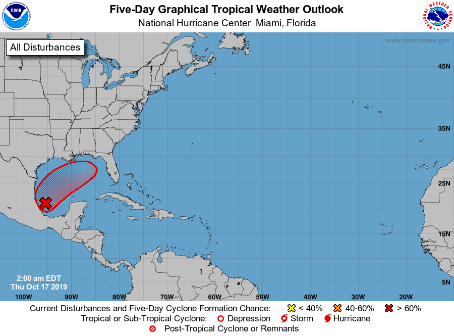
-
2019 Atlantic Hurricane Season
NavarreDon replied to AfewUniversesBelowNormal's topic in Tropical Headquarters
Nice write up from MOB on the possible impacts for my forecast area. SHORT TERM /Thursday night Through Saturday night/... Attention through the short-term forecast period will focus on the potential sub-tropical storm likely to develop across the southwestern Gulf of Mexico. A disturbance now organizing within the Bay of Campeche will begin to lift northeastward by Thursday night in response to southwesterly steering flow to the east of an upper level low pressure system over central Texas. The disturbance will likely become entangled with the upper low and frontal boundary initially stalled to it`s north. There will likely be a brief period where shear may relax slightly on Friday before the system interacts with stronger westerlies aligned along the northern Gulf Coast ahead of the next approaching upper trough. This may allow for some gradual strengthening of the surface low before reaching the northern Gulf of Mexico and becoming increasingly sheared. This system is likely to become increasingly baroclinic in nature before reaching the northern Gulf Coast and remain a hybrid type system. The potential for this system to be truly tropical when reaching the Gulf Coast appears low at this time. The ultimate track, timing, and intensity of the system is also in question as there remains model differences. The ECENS is further west and weaker with the GEFS to the east and stronger. This system has yet to form a low level center and there will likely be shifts in model guidance until this occurs. In addition, since this system will not likely be completely tropical in nature, there likely will be wind and rain impacts far from the center. At this point, we will continue to indicate increasing rain chances, gusty winds, and potential coastal flooding across our forecast area from Friday through Saturday night. Impacts will depend upon the eventual track and intensity. Please continue to monitor the latest forecast through the end of this week into the weekend. /JLH . -
2019 Atlantic Hurricane Season
NavarreDon replied to AfewUniversesBelowNormal's topic in Tropical Headquarters
18Z GFS never gets below 1000. Looks like 1-4” for most of the Panhandle. . -
2019 Atlantic Hurricane Season
NavarreDon replied to AfewUniversesBelowNormal's topic in Tropical Headquarters
System is now invest 96L https://www.tropicaltidbits.com/sat/satlooper.php?region=gom&product=ir -
2019 Atlantic Hurricane Season
NavarreDon replied to AfewUniversesBelowNormal's topic in Tropical Headquarters
Up to 50% on the 8:00am update. Totally agree on the drought buster benefits. It has been unbelievably dry in Navarre! .

