NavarreDon
-
Posts
2,890 -
Joined
-
Last visited
Content Type
Profiles
Blogs
Forums
American Weather
Media Demo
Store
Gallery
Everything posted by NavarreDon
-
https://twitter.com/JackSillin/status/1313085909504602113?s=20
-
Someone probably needs to open a dedicated thread on 92L. It’s got its cherry on the 5 day outlook.
-
Recon on the way Hmmm....did I miss something? .
-
.
-
Issues? .
-
.
-
And away we go! .
-
Tropical Weather Discussion ZCZC MIATWOAT ALL TTAA00 KNHC DDHHMM Tropical Weather Outlook NWS National Hurricane Center Miami FL 200 PM EDT Thu Aug 27 2020 For the North Atlantic...Caribbean Sea and the Gulf of Mexico: The National Hurricane Center is issuing advisories on Tropical Storm Laura, located inland over northwestern Louisiana. 1. A westward-moving tropical wave located over the far eastern tropical Atlantic near the Cabo Verde Islands continues to produce disorganized shower activity. Although environmental conditions are not expected to be conducive for development during the next couple of days, they are forecast to gradually become more favorable over the weekend and into early next week when the wave moves into the central and then western tropical Atlantic. * Formation chance through 48 hours...low...near 0 percent. * Formation chance through 5 days...low...20 percent. 2. Shower and thunderstorm activity has increased today in association with a tropical wave over the central tropical Atlantic. Gradual development of this system is possible over the next several days as it moves westward at 15 to 20 mph. * Formation chance through 48 hours...low...10 percent. * Formation chance through 5 days...low...30 percent. Forecaster Latto .
-
The ground is completely saturated. It wouldn’t take much to bring some trees down as we are closing in on 6”. We are fairly well prepped for weather including an evacuation plan. .
-
I realize that Laura is the hot topic but we are getting lashed with bands of tropical rain. 4” in the last 12 hours with more to come. Not much wind but it obviously mixes down when the rain gets heavy. .
-
Nice near term disco by MOB for my area this morning! NEAR TERM UPDATE /Now Through Tuesday/...As of this morning, the Tropical Storm Watch was cancelled for Mobile and Baldwin Counties in Alabama as well as George and Stone counties in southeast Mississippi. However, windy conditions will be possible today. Thus, a Wind Advisory was issued through 7PM CDT this evening for coastal Mobile and coastal Baldwin counties (mainly along the immediate coast) for easterly winds 15-25 mph with gusts up to 35 mph. /26 The main point is that the next 48 hours or so will be rather wet. Marco is currently in a world of absolute hurt as 30 knots of southwesterly shear from the upper trough over the ARKLATEX region has begun to decouple the low level circulation from the mid-level circulation. However as long as there is deep convection associated with the mid-level circulation, the low-level circulation will continue to attempt to move with the mid-level circulation causing the track to potentially shift a little more east than originally expected and the NHC`s latest track reflects that (about 20 mile eastward shift given the storms position). This really won`t have much of an impact on us as the shear will only increase with time and the low-levels will eventually decouple causing the low-level center to track westward and the mid-level center to continue moving north towards our area. Imagine the head of the storm going one way and the legs going the opposite direction. Since the mid-level circulation is expected to move across the area, a plume of 2 to 2.5 inches PWATs will overspread the area tonight into Monday. Typically with these highly sheared systems most of the rainfall ends up being well to the east from the actual center and in this situation thats us. Scattered to numerous storms will be expected as lift associated with that Mid-level center increases over the area beginning along the coast later tonight then slowly spreading inland throughout the day. So all in all rain chances will continue to stay high at least through Monday night and likely into Tuesday especially over southwestern Alabama and southeastern Mississippi. The main threat with these storms will be locally heavy rainfall given PWATS of 2.5 leading to likely efficient warm rain processes and rainfall rates likely approaching 2 to 3 inches per hour in the heaviest bands. Locally heavy rainfall of 3 to 6 inches will be possible along the coast with some locations getting locally higher amounts. For instance areas in Tallahassee`s area saw in excess of 7 inches today where a band setup for a couple of hours. These higher amounts will be based on where any banding sets up. Due to this, the flash flood watch will continue for coastal Alabama, southeast Mississippi, and far western Florida Panhandle. Along with the rain threat, an isolated tornado threat will be possible, given we are on the eastern side which typically supports the higher tornado threat. Luckily we will be removed from the low-level center and the better backed surface winds will be displaced to our west. I cannot rule out a tornado or two, especially during the late afternoon hours tomorrow into early tomorrow night. Winds will be gusty as well as storms mix down higher winds associated with the mid-level center. Some showers could have gusts to 30 to 40 mph. Luckily with all the rain, temperatures will be on the light side and will struggle to reach the low 80s. Lows will remain high though given the increased low level moisture throughout the period. Rip current risk will remain HIGH for quite some time and we had reports of 26 beach rescues yesterday at Pensacola beach alone. The water is not safe and a high surf advisory will also continue through the period. BB/03
-
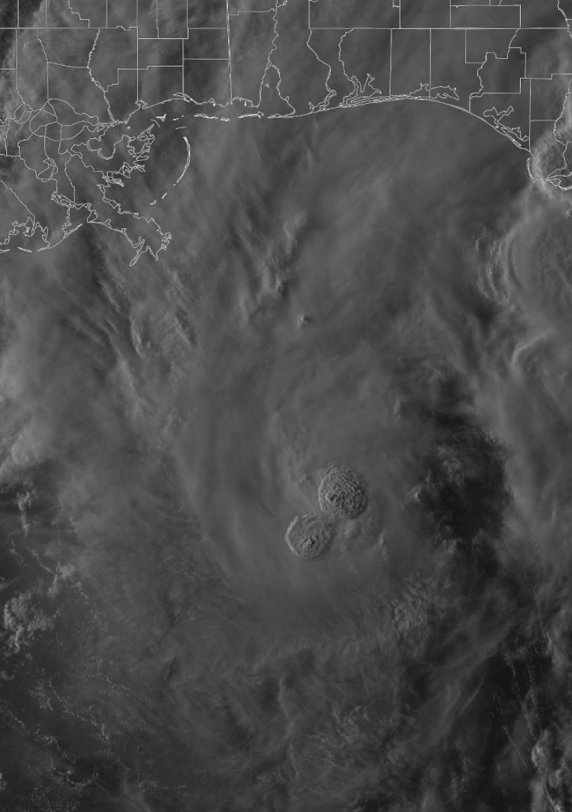
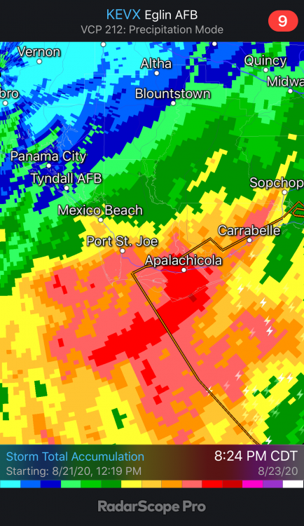
It’s been raining heavily all day from Port St Joe East thru Apalachicola. Here’s EVX totals. .
-
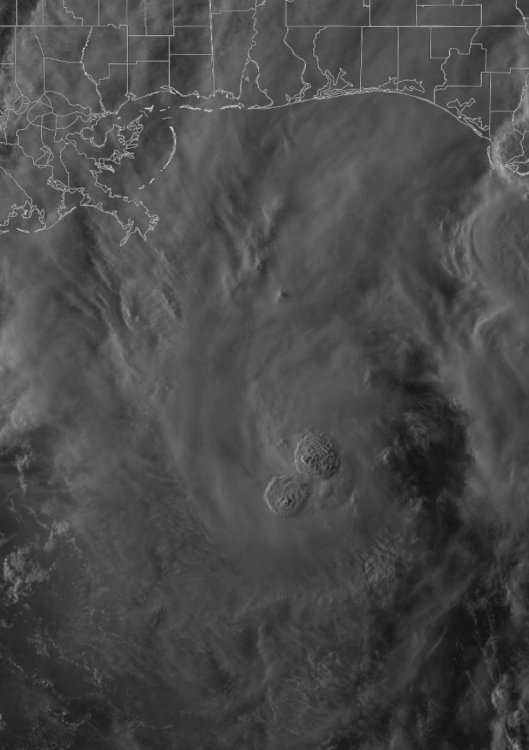
Looks like some towers firing around the center. Just got home and seeing some reports (TWC & Josh) saying there is a more N component to Marco. Any thoughts on this?
-
If they deem it a cane wouldn’t they do a special update before then? .
-
Tropical Storm Marco Discussion Number 10 NWS National Hurricane Center Miami FL AL142020 400 PM CDT Sat Aug 22 2020 Cutting to the chase, there have been some big changes among the model guidance, and subsequently the NHC forecast, for Marco this afternoon. While at this point it's a little speculative, the data collected by this morning's NOAA G-IV flight in the environment around Marco and across the Gulf of Mexico may have played a key role in the significant eastward shift seen in nearly all the 12z models. This isn't to say that the uncertainty in the eventual track has diminished. In fact, various ensemble members from some of the global models still show a potential risk to the coast anywhere from Texas to Alabama, and it's entirely possible that the volatile shifts seen in the models could continue. That being said, the new NHC track forecast has been shifted significantly eastward and now shows the center of Marco reaching southeastern Louisiana in about 2 days, which is the scenario currently shown by the GFS, ECMWF, HCCA, Florida State Superensemble, and the TVCN multi-model consensus. After Marco reaches the coast, the western Atlantic ridge is expected to build westward and should cause the cyclone to move more slowly toward the west-northwest across southern portions of Louisiana. As far as the intensity is concerned, the last fix made by this morning's reconnaissance flight indicated that the pressure had leveled off, and no higher winds had been observed from what was measured earlier in the flight. The radar presentation from Cuban radar has also degraded a bit, so Marco's initial intensity is held at 55 kt. Marco is beginning to move into a zone of moderate southwesterly shear, but otherwise favorable conditions of warm ocean water and some upper-level divergence are expected to foster strengthening during the next day or so. With the exception of the HWRF, the other intensity models show Marco reaching hurricane strength, and the NHC foreast continues to show that possibility while Marco moves over the central Gulf. The shear is still expected to strengthen in 36-48 hours when the system is approaching the northern Gulf Coast, but with the shift in the forecast track, now there may not be enough time for Marco to weaken below hurricane intensity before it reaches land. The new NHC intensity forecast is near or just above the HCCA and Florida State Superensemble models and holds Marco as a hurricane until it reaches the coast. The forecast track changes now bring tropical storm force winds to the coast in 36-48 hours, which necessitates the issuance of Hurricane and Storm Surge Watches for a portion of the northern Gulf Coast. These watches will likely need to be upgraded to warnings later tonight. Key Messages: 1. Tropical storm conditions will continue over portions of extreme western Cuba through this evening. Heavy rainfall is also expected in the eastern portions of the Mexican states of Quintana Roo and Yucatan, and across far western Cuba, which could result in flash flooding. 2. Marco is expected to approach the central Gulf Coast as a hurricane on Monday. Hurricane conditions, life-threatening storm surge, and heavy rainfall are possible along portions of the Gulf Coast beginning on Monday, and Hurricane and Storm Surge watches have been issued. Interests in these areas should follow any advice given by local government officials. 3. Tropical Storm Laura could bring additional storm surge, rainfall, and wind impacts to portions of the U.S. Gulf Coast by the middle of next week. This could result in a prolonged period of hazardous weather for areas that could be affected by Marco. Interests there should monitor the progress of Marco and Laura and updates to the forecast during the next few days. FORECAST POSITIONS AND MAX WINDS INIT 22/2100Z 21.9N 85.7W 55 KT 65 MPH 12H 23/0600Z 23.3N 86.5W 65 KT 75 MPH 24H 23/1800Z 25.3N 87.3W 75 KT 85 MPH 36H 24/0600Z 27.5N 88.3W 75 KT 85 MPH 48H 24/1800Z 29.3N 89.6W 65 KT 75 MPH...ON THE COAST 60H 25/0600Z 30.4N 91.1W 50 KT 60 MPH...INLAND 72H 25/1800Z 31.1N 92.7W 40 KT 45 MPH...INLAND 96H 26/1800Z 32.3N 95.6W 25 KT 30 MPH...INLAND 120H 27/1800Z...DISSIPATED $$ Forecaster Berg .
-
Not the best with models but it looks like the 12Z GFS is initializing with Marco @ 1005. Will this cause issues with the whole run? .
-
Seems like 98L is getting the bulk of the posts atm. 97L got its cherry as of the 2pm TWO. As has been said models will continue to struggle until formation regardless, its going to be an interesting week. .
-
Didn’t follow it all day but I’m thinking that’s likely what happened. .
-
Tropical Weather Outlook NWS National Hurricane Center Miami FL 800 PM EDT Sun Jul 5 2020 For the North Atlantic...Caribbean Sea and the Gulf of Mexico: The National Hurricane Center is issuing advisories on Tropical Depression Five, located a few hundred miles northeast of Bermuda. 1. A small low pressure system is located over the northern Gulf of Mexico about 100 miles south-southwest of Panama City, Florida. While the low currently has limited thunderstorm activity, some development is still possible before it moves inland early Monday. This system is expected to evolve into a larger low pressure system and move northeastward, possibly emerging offshore of the Carolinas later this week where environmental conditions are expected to be more conducive for development. * Formation chance through 48 hours...low...20 percent. * Formation chance through 5 days...medium...40 percent. 2. A strong tropical wave, centered about 700 miles east of the Windward Islands, is producing disorganized showers and thunderstorms. Some slight development of this system is possible on Monday before environmental conditions become hostile for development on Tuesday. The wave is forecast to move through the Lesser Antilles on Tuesday and could produce locally heavy rainfall as well as gusty winds on some of those islands. * Formation chance through 48 hours...low...10 percent. * Formation chance through 5 days...low...10 percent. Forecaster Blake The N Gulf low is really distinctive on EVX!
-
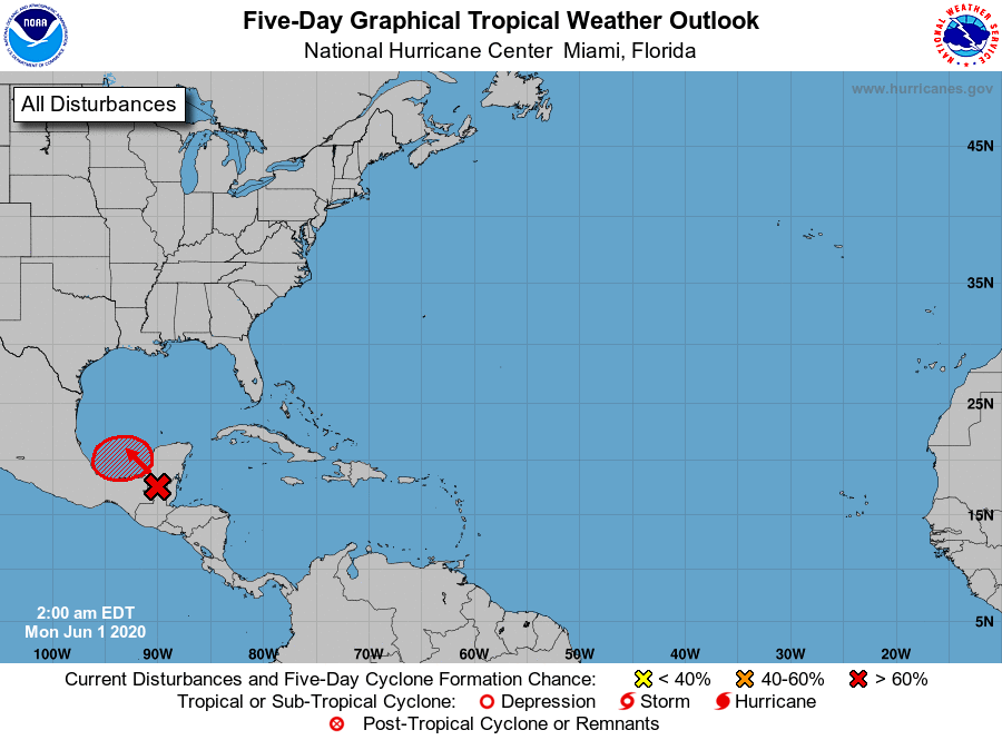
We have a cherry. Tropical Weather Outlook NWS National Hurricane Center Miami FL 200 AM EDT Mon Jun 1 2020 For the North Atlantic...Caribbean Sea and the Gulf of Mexico: 1. The remnants of Eastern Pacific Tropical Storm Amanda are currently located inland near the Guatemala-Yucatan Border. This large disturbance is forecast to move slowly northward this morning, followed by a northwestward motion later today, and the center of the low pressure system could emerge over the southeastern Bay of Campeche by this evening. If the remnants move back over water, environmental conditions appear conducive to support some development, and a new tropical depression could form while the system moves little through the middle of this week. Regardless of tropical cyclone formation, heavy rainfall is likely to continue over portions of southern Mexico, Guatemala, El Salvador, Belize, and western Honduras during the next few days. For additional information on the rainfall threat, see products from your national meteorological service. * Formation chance through 48 hours...medium...60 percent. * Formation chance through 5 days...high...70 percent.
-
.
-
Up to 40% 48hrs & 50% 5 day https://www.nhc.noaa.gov/xgtwo/two_atl_5d0.png .
-

2019/2020 Mountains and Foothills Fall/Winter Thread.
NavarreDon replied to Tyler Penland's topic in Southeastern States
My Brother just east of Glenville and at elevation has between 3-4”. . -
2019/2020 Mountains and Foothills Fall/Winter Thread.
NavarreDon replied to Tyler Penland's topic in Southeastern States
My brother outside of Glenville has a solid inch so he’s on par with you! . -
2019/2020 Mountains and Foothills Fall/Winter Thread.
NavarreDon replied to Tyler Penland's topic in Southeastern States
Morning guys, just wanted to say a couple things. Think this is going to be a decent event for some of you. It seems like some are apprehensive. Anyone closer to the 85 corridor has the right to be. If you’re up in the Mnts try to take emotions out of what you are or are not seeing. Use technology and synoptics. If your not the best model reader lean on GSP’s AFD’s they are a wealth of knowledge and have pretty much everything that’s been happening in print with the reasons why. With all the micro climates up there you’re going to have the usual over & under achievers. But don’t rush to judgment based on emotion. Use the tools at hand to understand what’s happening and why. Sorry for the rant & I hope all of you overachieve!!! .