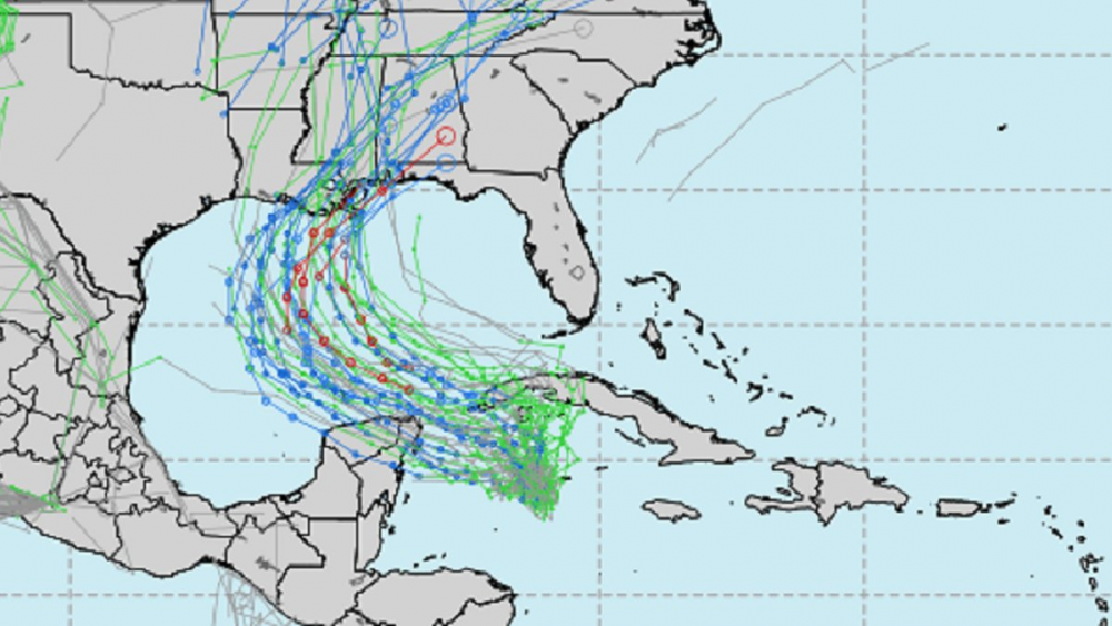
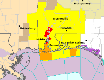
Yikes! 064 WTNT41 KNHC 062034 TCDAT1 Hurricane Delta Discussion Number 9 NWS National Hurricane Center Miami FL AL262020 500 PM EDT Tue Oct 06 2020 Shortly after the release of the 1500 UTC advisory package, the NOAA Hurricane Hunter aircraft measured a peak flight-level wind of 132 kt, and during its final passage through the northeast eyewall around 1700 UTC it reported a peak SFMR wind of 121 kt. The aircraft continued to report an extremely small 4-to-5-nmi-wide eye. The central pressure did level off somewhat on the final couple of penetrations, with the latest reported central pressure at 956 mb. The initial wind speed was raised to 120 kt on the earlier intermediate advisory, and has been set at 125 kt for this advisory. The next reconnaissance aircraft mission into the hurricane is scheduled for this evening. There has been no evidence of an outer eyewall from the aircraft reports or earlier radar imagery from Grand Cayman. As a result, some additional strengthening is likely to occur before Delta reaches the northeastern coast of the Yucatan peninsula late tonight or early Wednesday. The NHC intensity forecast is once again a little above the various intensity aids until landfall in Mexico. When the small inner core of Delta moves over land, weakening is expected, but warm waters and low vertical wind shear over the southern Gulf of Mexico should support re-strengthening, and a second peak in intensity is likely when Delta is over the central Gulf of Mexico in 48-60 hours. After that time, increasing southwesterly shear and the cooler shelf waters over the northern Gulf are expected to cause some reduction in wind speed. The global models, however, depict a significant increase in the size of Delta's wind field while it is over the Gulf of Mexico, which increases the spatial extent of the storm surge and wind threats for the northern Gulf coast. So regardless of Delta's final landfall intensity, the projected large size of the hurricane is likely to result in a significant storm surge and wind event for portions of the northern Gulf coast later this week. Delta has been moving steadily west-northwestward today at 300/15 kt. The track forecast reasoning remains unchanged from the previous advisory. A mid-level ridge over Florida and the northeastern Gulf of Mexico is expected to continue steering Delta west-northwestward during the next 36-48 hours. After that time, a developing trough over the south-central United States should cause Delta to turn northward, and by Friday the hurricane is forecast to begin accelerating northward or north-northeastward ahead of the trough. This motion will bring Delta onshore along the northern Gulf coast between 72 and 96 hours. The dynamical models continue to be tightly clustered through 48-72 hours with some increase in spread thereafter. The overall trend in the guidance has been slightly westward, and the new forecast has been adjusted accordingly and lies near the middle of the envelope. Supplemental upper-air balloon launches at 0600 and 1800 UTC have begun at upper-air sites across portions of the southeastern United States. In addition, a NOAA G-IV synoptic surveillance mission is in progress and should provide additional data for the 0000 UTC cycle of the dynamical models. Key Messages: 1. Life-threatening storm surge and potentially catastrophic wind damage are expected within portions of the northern Yucatan Peninsula of Mexico beginning tonight. All preparations to protect life and property should be rushed to completion. 2. Heavy rainfall will affect portions of the Cayman Islands, western Cuba and the northern Yucatan Peninsula through midweek. This rainfall could lead to significant flash flooding and mudslides. The potential for heavy rain, flash and possible minor river flooding will increase across portions of the central Gulf Coast, Tennessee Valley, and southeastern United States as Delta moves inland later this week. 3. There is an increasing likelihood of life-threatening storm surge and dangerous hurricane-force winds, especially along the coasts of Louisiana and Mississippi, beginning on Friday. Residents in these areas should ensure they have their hurricane plan in place and follow advice given by local officials. Storm surge and hurricane watches will likely be issued for portions of the northern Gulf Coast on Wednesday. FORECAST POSITIONS AND MAX WINDS INIT 06/2100Z 18.9N 84.1W 125 KT 145 MPH 12H 07/0600Z 20.2N 86.1W 135 KT 155 MPH 24H 07/1800Z 21.8N 88.8W 105 KT 120 MPH 36H 08/0600Z 23.0N 91.1W 110 KT 125 MPH 48H 08/1800Z 24.4N 92.6W 115 KT 130 MPH 60H 09/0600Z 25.9N 93.2W 115 KT 130 MPH 72H 09/1800Z 28.0N 92.9W 110 KT 125 MPH 96H 10/1800Z 32.4N 90.9W 55 KT 65 MPH...INLAND 120H 11/1800Z 35.5N 87.3W 20 KT 25 MPH...POST-TROP/REMNT LOW .