

nrgjeff
-
Posts
3,902 -
Joined
-
Last visited
Content Type
Profiles
Blogs
Forums
American Weather
Media Demo
Store
Gallery
Everything posted by nrgjeff
-
Regrettably the Euro has managed to kill the juxtaposition of instability and shear. One of many reasons I'd like to forget any 12Z runs ever happened. Oh well!
-
12Z Euro lights up Dixie Alley in less than a week. However it is just one run. If the advancing front is slow enough out of the Midwest, two waves are forecast in three days. Such a solution would give more time for moisture return ahead of the second one.
-
Hopefully the ECMWF finds some thunderstorms in the 6-10 day. I'm ready for severe wx season. Reality is a trough hanging out west for multiple days allows moisture return into Dixie. Bring out a shortwave, and boom! Once I take down the Christmas tree, severe wx season can start anytime.
-
Cheeseland is passionate about severe wx and welcome here. Note the smiley face. I was going to take down my Christmas tree MLK Day weekend. If it is still up Monday, I will also use the shutdown reasoning as a later deadline. Wetumka tornado is an unfortunate verification of the 5%. These things can happen with a dynamically forced line marginal instability. Most importantly sky will clear out in time for the lunar eclipse tonight! High clouds could come into the northwest quad of our Region but not a show stopper.
-
Saturday showcase includes thunderstorms. CAMs mostly line out the activity which is not a surprise. Line will be very forced with limited instability. Kinematics and wind field looks excellent. Rain and clouds should keep it a little cool though. If instability somehow verifies higher it might be worth a second look on a weekend. Otherwise the real show is the ESPN Saturday Showcase; lots and lots of good college basketball. Sunday evening should clear out in time for the lunar eclipse. Yes, back to fair weather chasing.
-

MO/KS/AR/OK 2019-2020 Winter Wonderland Discussion
nrgjeff replied to JoMo's topic in Central/Western States
NAM raised snow amounts like it is playing catch up to the Euro. NAM still relatively lower amounts might be due to surface and ground temps. However right after Thanksgiving the Euro scored a big coup even inside the time frame where the NAM should prevail. Might have happened one other time, but I remember Thanksgiving more thanks to visiting KCMO. Looks like a big I-70 special from KC to STL. Everyone enjoy! And the Chiefs better win!! PS. Climate blog looks solid. More TV Mets should do that. -
No high risk. 975 tornadoes. I know that's less than 2018 prelim. We lack the baroclinicity in the current climate regime. If the cold verifies in February, those lingering effects of the SSW may fade by April. Everything a month ahead of last year? Get Dixie going in April. Plains craps out again in May. If the Chiefs win a playoff game I may be more optimistic across the board.
-
ECMWF and CFS monthlies both show April better than May. Fits El Nino climo. So I will look early and often in Dixie. Plains may be yet another crap May. No EML in the Plains means slop. If I'm going to chase slop, Dixie is a whole lot closer!
-
Bye bye severe wx season.
-
Education and Questions/Discussion Regarding Weather Features
nrgjeff replied to EastKnox's topic in Tennessee Valley
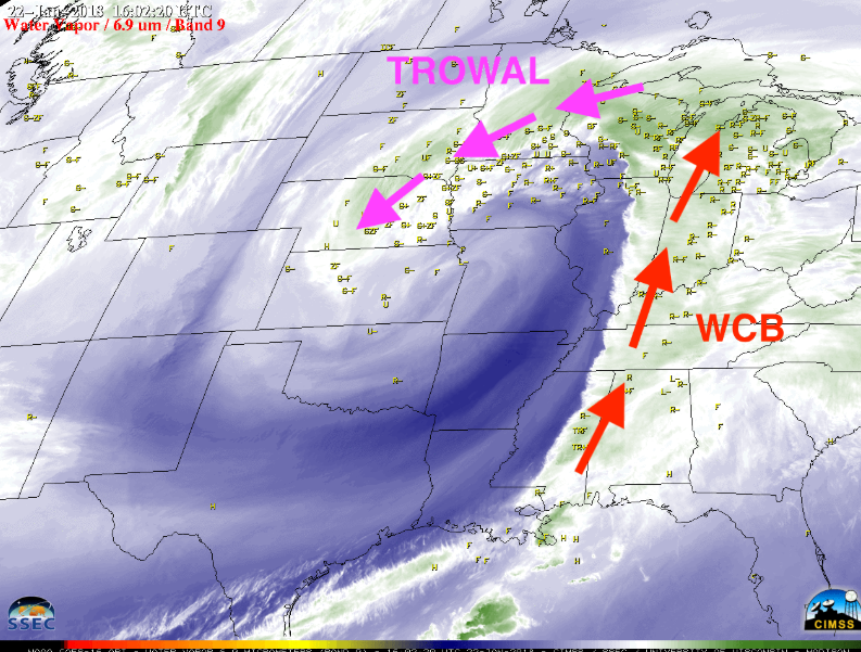
I promised some TROWAL explanation on the Dec 8-10 storm thread. Trough of Warm air Aloft stands for TROWAL. It often happens behind an occluded front/system. One can easily find cross section diagrams of an occlusion with a web search. However these two images show what I'm looking for when forecasting. Here it is on satellite, an old storm over the Great Plains. Bring it baby! On an 850 mb chart (also 925/700) one can see WAA from the north, vs usual southeast. Average comma head is associated with the cold conveyor belt, and some split off the warm conveyor belt. Usually the better precip is off the more robust warm conveyor belt. (Conveyor belts are also an easy web search.) TROWAL feature is interesting because it can amp up the normally secondary comma head. WAA is notable into the comma head. Example below is ECMWF forecast valid Monday. Most of the snow has fallen, but the 850 mb chart shows it better at the end of the event. Note WAA from north to south. Favors I-40 north. CAA south of I-40 shuts off precip.
-
Education and Questions/Discussion Regarding Weather Features
nrgjeff replied to EastKnox's topic in Tennessee Valley
The question is age old in the South. True that textbook HP is fair weather. However we do need a supply of low level CAA for snow. At the same time we need WAA aloft to create the precip. It is a delicate dance anywhere. In the South it's a delicate dance on a tight rope that often results in a fall, lol! Sometimes 500 mb offers the answer. PVA just south, with surface low farther south (a good tilt) and cold air in place, usually good. PVA at latitude / overhead, risk of ice if cold air in place. PVA north, probably rain. EDIT for below: I did not realize Knoxville climo has shifted so much. Yuck! -
I remain bullish, slightly cold, for winter. Current El Nino is moderate, but it's only a snapshot. Two of the last three weak/mdt El Ninos briefly spiked strong before trailing off. Those were 2002-03 and 2009-10 both cold winters. Most recent weak-mdt El Nino 2014-15 stayed below moderate; it was also a cold winter. November verified cold eastern half to 2/3 of USA. It looks similar to 2014, but that year was colder to the East Coast. This year remember the cutter systems? Snow fans of course want that to end. Anyway 2014-15 was the last snow thump in Chattanooga. I'm quite comfortable with ENSO at the moment.
-
Saturday afternoon events Middle Tennessee and points west might luck out if rain can get out before events start. John I hope the Christmas parade works out. I've lost interest in thunderstorms; so, I will hope for fair weather. Appears severe starts Friday in the Ozarks; even more LOL with early sunset. Saturday dynamics seem to drift north of instability; so, rain here should be fairly benign. Rain timing should be in the morning many areas, including Mid-Tenn. Might still be afternoon showers in East Tenn. GFS is slower (wetter for Mid-Tenn) but ECMWF and NAM both push out the rain in time.
-
ECMWF remains consistent with a chance of severe weather Friday night and Saturday from the Mid-South to the eastern Tennessee Valley. Many details need to work out from instability to short-wave timing. Looks like multiple waves, which can giveth or taketh away. I infer from the text SPC really wants to outlook Saturday, but I agree it would be hard to place the 15%. Too early to worry for those who dislike severe. Just those of us who like it, we want to track it. Honestly, at Day 6, it is not any more likely than snow in Dixie, lol! PS.. I will comment on December after the ECMWF weeklies update. Maybe I should have stayed with Carver for Dec. Did I go cold too fast?
-
MO/KS/AR/OK 2019-2020 Winter Wonderland Discussion
nrgjeff replied to JoMo's topic in Central/Western States
I was in KCMO for Thanksgiving and enjoyed tracking the storm. Interesting that at 30 hours the ECMWF just schooled the NAM. I joke about the latter choking 36-48 hours out, but it should beat the Euro and GFS inside 36 hours. NAM finally caught on farther south by 24 hours out. Euro was first to sniff out the vort max keeping south. NWS did a great job going Blizzard Warning. Plains pattern recognition promotes doing so with a tight vigorous vort max and deepening surface low press. Then, how about some thunder snow? Little busy with family to post or look deeply, but I was following it. For safety we departed Saturday evening before it started, so I missed the real fun. Wish the blizzard had been a day earlier. -
European weeklies have a possible pattern the week after Thanksgiving week; so, a little later into the end of November.
-
I'll go with the ECMWF Euro as usual. Either way it is rainy crap weather on Election Day. Consider early voting if not already done, weighing the next two days also. Halloween is today and looks like rain tomorrow (Thursday) which is the last day of early voting. I respect no politics on the weather board; we love weather first. Just a note on weather related logistics. Happy and safe Halloween!
-
The increase in tornado activity on the Delta is convenient because it is flat. However that is just change (delta on the Delta, lol). The Delta is still a local min within Dixie Alley. Maybe it will change.
-
Confidence is greater on El Nino after data the last couple weeks. I've been around but quite busy at work and home with activities. Also American Wx fell off my routine when it crashed for a few days. El Nino could still turn out basin wide, but odds slightly favor Modoki.
-
CFS is also on fire all winter. Both models may be influenced by generally warm oceans over the entire Northern Hemisphere. Perhaps the late bloom of El Nino will behave more like weak Nino; and, get us some winter back half per ECMWF.
-
Too bad the TNI may be completely backwards for severe next spring.
-
Looking back through the 2000s when the surface and below-surface cross-sections look like now, odds are pretty good for the weak/moderate El Nino. Right on the cusp of the two would be great! (Office Space meme) Few folks are haunted by the ghosts of last year. This year is quite different. LY had started to crater by August. Consensus in the energy world is weak/mdt El Nino. It might fade mid-winter but does not break the deal. They are supposed to peak in late fall early winter; hence, the name. Literally it is the Christmas Child, El Nino in Spanish.
-
Starting Monday it looks cooler again, perhaps for most of next week with scattered thundershowers. Tuesday is currently the day models/NWP highlights for heavier storms in the Valley, but it has shifted around. 36 hours ago NWP favored Monday. At any rate a synoptic system with quality upper level wind fields is forecast early next week for the Valley. Looks mainly eastern half of our region perhaps Tuesday. GFS has upper level wind speed but mostly same direction. Euro has more turning upstairs, upper system a bit more open. If it rains the day before, chance of an outflow boundary increases. If timing changes it could be Mid Atlantic (per NWP 36 hours ago). Finally we'll see if the wind field forecast holds up. Most days with thundershowers should not be severe. Over five days we should be able to absorb that QPF without major flooding concern, at least in Tenn. However the devil is in the local details. Local flash flooding is always possible with thunderstorms. Also with sustained southeast flow, Georgia and up the Blue Ridge could have a lot more precip.
-
Friday night set up east of the highest SPC probabilities. Believe the main problem was a warmer layer (cap) for Middle Tenn. Meanwhile a boundary set up from Kentucky to North Georgia. It started out in Middle Tenn. but was capped. Despite lower overall parameters east, the low levels closed the deal. Boundary enhanced low level shear. It got real near Spring City for a bit. Neighbors and I were watching the distant lightning. Watching the lightning reminded me of waiting for nocturnal storms back in the Plains. However we were concerned for the people up in the tornado warning.
-
I am sitting out today, mainly due to terrain. Iowa tornadoes did pique my interest but they had greater low level turning. Iowa tornadoes is all or nothing like snow in Dixie, lol.. Today in TN/KY deep layer shear is downright robust for July. CAPE should achieve advertised levels. My issue is the lowest level shear. Even adjusted for a northwest flow event I don't like the lowest 100 mb or so. From 850 mb up turning is good. However from 850 mb down speed is meh. I know it's July. Still I like the lowest levels to close the deal for tornadoes. It requires a quality boundary. Attm (1643Z surface chart) winds do not kink well along the boundary near the TN/KY border. We'll see how things go. Looks like plenty of straight line wind and even large hail for severe weather fans. OHX is rightfully hitting the straight winds in their comm. Can't take tornadoes off the table in the MDT and immediate surrounding ENH area (not all of it). Note max tornado probabilities are ENH. The other modes of severe wx could achieve MDT. If the terrain were better, today might be worth a try in West Kentucky and adjacent parts of Tenn. The meteorology looks like few and brief tornadoes, easily missed in poor terrain. Appears the wind and hail will be the primary issues.


