nrgjeff
-
Posts
3,903 -
Joined
-
Last visited
Content Type
Profiles
Blogs
Forums
American Weather
Media Demo
Store
Gallery
Everything posted by nrgjeff
-
Low CAPE high shear events happen. Wait! This was not exactly that... I'm watching KPAH get the hail treatment about 5pm Monday. Back of my mind I know it's westerly flow aloft over a boundary - but a little early in the season for that set-up. Text my buddy a boundary rider is going off on PAH, but don't think too much about it. Cell weakens, and I start gearing up for Big Monday college basketball on ESPN. Wake up Super Tuesday to Middle Tennessee super tragedy on the news. WTF? Going back to Monday afternoon shear was never in question. I've written here many times, look for westerly flow aloft instead of that SSW flow junk. Nearly 90 degrees of turning was noted. 850 was a little veered, but upstream was deep moisture - count it as backed in Dixie. 925 mb was straight south and both increased going overnight - all forecast ahead of time! Surface of course had the notorious boundary related SRH. CAPE and instability was more complicated. Steep mid-level lapse rates were in place, but low-level CAPE was close to zero. Forecast soundings had the latter improving; but, I'm such a skeptic of those. Normally early season other rain is falling, and it remains stable. Well no rain was falling south of the boundary. Surface chart in retrospect shows an unstable airmass advecting in unfettered. Sure enough it arrived at the boundary in Middle Tennessee. LLJ strengthened. Alas the 2% TOR area was under the gun. CAMs actually had robust storms, but not necessarily a boundary rider beast. Old fashioned meteorology could have provided a more obvious heads up before the evening news. However, credit some local TV Mets for sounding the alarm on the evening news. Still, it's tough to overcome a 1am long-track cyclical damaging tornado. Dixie Alley is just so awful. It's either busted chases, or much much worse. The human suffering down here is cruel. At least the Vols cheered up Tennessee. https://davieswx.blogspot.com/2020/03/march-3-2020-double-digit-death-toll.html excellent article from Davies.
-

2019/2020 Mountains and Foothills Fall/Winter Thread.
nrgjeff replied to Tyler Penland's topic in Southeastern States
Even the stubborn Euro gives snow above 4,000 FT. Thickness and 700 mb Ts fall with precip. Thursday is happening at the ski areas. Then we have Friday NWFS. -
Flash Drought, but still humid AF and AN temps. Yuck!
-
2019/2020 Mountains and Foothills Fall/Winter Thread.
nrgjeff replied to Tyler Penland's topic in Southeastern States
Thursday could do it front side above 3,500 FT, but more likely at/above 4,000 FT. NAM is cold surface temps, but has a warm nose at 700 mb, though it's early to drill down that far on the NAM. Euro holds 700 mb below freezing, but surface temps are right only above 4,000 FT. Also got the NWFS section Friday. Overall paint me optimistic for the true mountains and ski areas. Lower elevations cliff dive advisory could be upgraded to warning (552 thickness). Anyway it looks like the ski areas can get another good weekend which is nice for business. -
ERTAF has begun! Cue up, It's the Most Wonderful Time of Year! Agree with them though, it looks benign for a while. Just as well until after the Final Four. Japan satellite shows the two Kelvin waves (MJO pulses) well. Also got a trough trying to dig into central China. Probably get a ton of MJO interference though. Though both sets of weekly forecasts appear on fire with the West trough, devil is in the details. Soft underbelly Deep South hints split flow chaos.
-
February/March 2020 Winter's Last Chance Thread
nrgjeff replied to John1122's topic in Tennessee Valley
MJO problems will keep the weather models as volatile as the stock market this week. Just when we think snow is possible; boom, downside reversal! I still miss Chattanooga's ultimate upside reversal on Feb. 8 sorry I've mentioned it on two threads in five minutes. In all seriousness, I still consider TRI and the Upper Plateau in the game Friday night for wrap around and/or slight NWFS. Maybe I just want to ski one more time. -
Leap Days Clipper Parade: February 26th-29th 2020
nrgjeff replied to John1122's topic in Tennessee Valley
My guess is some convergence in the wake misses you to the northwest. Have you ever checked up 27? Hypothesis is based on trajectory exactly parallel to the mountains. If from the west or northwest, I figure everybody gets killed by downslope. We know a lot about that in Chattanooga off the Plateau, lol! In other news, Friday evening I'm so glad I missed MRX updating for the Chattanooga area. Never even saw that update. Watched Netflix when it became obvious KCHA temps would hang up as usual. Good for those who got snow OK with the system. Despite the wonderful Feb. 8 surprise, KCHA has adjusted back to just being the cheering section. -
Super Tuesday severe setup is now hampered by sharp divergence between the progressive GFS and slower Euro. Truth may end up in between, but mostly toward the Euro. As for north/south tracking, EC Op surface low is buried in the Deep South. However the vast majority of its EPS (Ensemble) members have surface lows farther north including the Midwest. That's more severe and more heavy rain here. No wind fields analysis since the whole thing is a cluster now. One can imagine the north members have better wind fields. South members are cool rain. Heck now we can't even pick out the day or the place. Tuesday Wednesday or Thursday anywhere from the Delta to the Carolinas; but, probably only one day where everything comes together for severe in just a couple states. Flooding rain is a different story in a different thread.
-
TN valley heavy rain/flooding week of whenever
nrgjeff replied to janetjanet998's topic in Tennessee Valley
Last time the Euro won this battle. It's less flooding and less severe. This case I'll punt my love of severe and pray for lower QPF. -
Oh the storm from The Day After Tomorrow sinking south - like the stock market! In sports, the WWE chair rematch is this weekend! KU at K-State is on CBS Saturday!
-
Leap Days Clipper Parade: February 26th-29th 2020
nrgjeff replied to John1122's topic in Tennessee Valley
Chattanooga started as snow, but changed to rain. Fitting as the DOW drops another 1,000 I'm looking forward to when the DOW = Doppler on Wheels. If it's not going to stick, severe? -
TN valley heavy rain/flooding week of whenever
nrgjeff replied to janetjanet998's topic in Tennessee Valley
ECMWF backed off severe a touch, but seems to have shifted the highest QPF into the heart of TVA. Only good news is that high QPF isn't as high as shown 12 hours ago elsewhere. On the severe side, several EPS ensemble members are more like the previous runs. Low press into the Midwest and severe here. EC Op is frontal overrunning. -
Leap Days Clipper Parade: February 26th-29th 2020
nrgjeff replied to John1122's topic in Tennessee Valley
The last two systems illustrate the importance of cold air and surface, I know kind of duh, but these last two systems really accentuate it. I'll add cold air in place vs JIT junk. I observed first flakes in Downtown Chattanooga around 8:30 Eastern, but not doing much attm. Actually I observed driver flakes on the way in too, but that's another topic... -
Leap Days Clipper Parade: February 26th-29th 2020
nrgjeff replied to John1122's topic in Tennessee Valley
Upper Plateau and points north of I-40 look good for the two waves coming through from Friday morning through Friday night. Diurnal timing will play a role with accumulation. Plateau should have no problem accumulating, temps below freezing many hours. Valley I-40 north will battle temps more. Knoxvegas maybe. Morristown I'd think a little. TRI good. Nashvegas is the real craps table. I'm afraid Huntsville and Chattanooga are relegated to the cheering section again. Maybe snow showers, but I really doubt stick. My head is back to default fade KCHA. My heart is still stuck on 8 Feb. -
February/March 2020 Winter's Last Chance Thread
nrgjeff replied to John1122's topic in Tennessee Valley
Euro weeklies are worse than the stock market action this week. -
TN valley heavy rain/flooding week of whenever
nrgjeff replied to janetjanet998's topic in Tennessee Valley
Euro weeklies just piled on for a bunch of rain next week. Just awful. -
Euro retains at least 30 degrees of turning from 850 to 500 mb, and some runs it's close to 45 degrees. Speed shear is pretty much a given. If that directional shear verifies (tendency to get more uni-directional toward the day) and holds it could be a significant severe weather episode. Probably mostly Deep South though, not really our region. At least south of I-40. I was supposed to give up storm chasing for Lent, to keep me out of early season junk. Hmm, what else?
-
2019/2020 Mountains and Foothills Fall/Winter Thread.
nrgjeff replied to Tyler Penland's topic in Southeastern States
Gorgeous in Maggie Valley! @Maggie Ace What's the chance Catalooche opens the Meadows? Friday night should over achieve, I hope. -
2019/2020 Mountains and Foothills Fall/Winter Thread.
nrgjeff replied to Tyler Penland's topic in Southeastern States
Don't underestimate the power of the Force, convective NWFS. Good luck! Oh MRX probably has more real estate and population up high; hence, the warnings. Friday night may do better than progged too. They keep drying out, but I bet the ski areas get more. -
Wild Speculation for Winter 20 -21
nrgjeff replied to Holston_River_Rambler's topic in Tennessee Valley
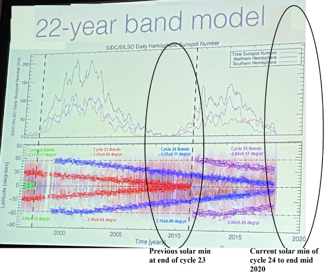
He's wrong. Looking for attention. I don't see anyone by that name with credentials on Linked In. Currently the Milankovitch Cycles approximately cancel out each other. That's why Climate Science can more reliably zero in on the solar cycle and Carbon. The divergence is startling. Sun is sleeping; temps and CO2 continue up; and previously, they had always all 3 been in lock step. -
Tuesday 12Z Euro buys in for Day 8 Mid South. Winds turn enough with height, a new development, and dews are there. However it could fall apart the next 7 days. Either way I expect an active March. Trough in the west and Rockies.
-
Wild Speculation for Winter 20 -21
nrgjeff replied to Holston_River_Rambler's topic in Tennessee Valley
Above agrees with consensus on the Solar Forecast too. But if the Contrarian verifies, we already had our minimum. Head over to the Climate Change threads. -
February/March 2020 Winter's Last Chance Thread
nrgjeff replied to John1122's topic in Tennessee Valley
It's not a weapon with only 2% fatal (greater than flu less than SARs). However it could be a virus animal experiment gone awry. China shut down. Less pollution. Something about the MJO. More cold in the Southeast US. China reopens. SER in March. Well, I doubt that, but we need to get back on topic. Thursday snow showers are looking a little better for the Plateau and Mountains; but, I think Friday night is more interesting. Friday night and Saturday still looks on-track north of I-40, Plateau, Mountains and probably TRI. Might even be Knoxvegas. We'll go snow dome BNA/CHA. -
February/March 2020 Winter's Last Chance Thread
nrgjeff replied to John1122's topic in Tennessee Valley
Saturday Feb. 29 has echos of Sat. Feb. 8 for the Valley. Cold air in place instead of that JIT crap for starters. Models correctly default to no snow Valley climo. We'll have to watch it as it evolves. Full and partial thicknesses are buried. 850/700 mb charts have neutral to slight WAA while remaining cold. Little far out to look at soundings but what the heck? Deep moist layer reaches forecast DGZ. Just need some isentropic lift that zone, likely verbatim but Day 6. We'll see! -
Wild Speculation for Winter 20 -21
nrgjeff replied to Holston_River_Rambler's topic in Tennessee Valley
AMS paper from U. Maryland has a contrarian view we may be heading into a major / active solar cycle. Hypothesis is solar storms dragged out cycle 23. This cycle 24 has been a little short in time duration and solar storms. Getting ready for 25 to roar out of the gates strong. Endless warm winters! Again it's just a contrarian hypothesis. But it would mesh with 2012 going into a warm 2012-13 winter. If anything can go wrong...