nrgjeff
-
Posts
4,261 -
Joined
-
Last visited
Content Type
Profiles
Blogs
Forums
American Weather
Media Demo
Store
Gallery
Everything posted by nrgjeff
-
Thanks MRX I'll look forward to that sh!t after dark. At least it'll still be evening, not late night. Remember even storm chasers don't like that crap after dark. Virtual chase target is northeast Mississippi to northwest Alabama, into southern Middle Tenn. That's hideous chase terrain so no real chasing. Lunch in Corinth, Miss. would offer options south into Miss. or back east into Bama. However the immediate tri-state (with TN) is completely unchasable terrain. Punt! Oh yeah, lots of college football on today too. Cheers!
-
My take of the 12Z Tuesday guidance is after dark, but not super late. Short wave looks a little clumsy. I guess that's non-technical talk for odd ejection with poor low level wind fields. CAPE is high for this time of year, so any uptrend in low level wind fields would have to be watched closely. Look for heavy rain and some severe, but I don't think Wednesday evening will be too bad (if low level wind field forecast holds meh).
-

Fall/Winter Banter - Football, Basketball, Snowball?
nrgjeff replied to John1122's topic in Tennessee Valley
I was actually going to take Tennessee. I heard Bama rebounds poorly this year. Day of news check, I'll see if Tennessee tall guys are back before wagering. Not investment advice. Oh yes @Carvers Gap Tennessee will be well prepared for March! -
We'll go storm chasing if you're here through the weekend. I will opine on the January cold after forecasting Wednesday and weekend severe. Feeling the latter gets muddled with Arctic air in the equation. Wednesday on the other hand features a spring-like stalled boundary.
-
Fall/Winter Banter - Football, Basketball, Snowball?
nrgjeff replied to John1122's topic in Tennessee Valley
Tennessee at Alabama a Yuge game coming up. It's basketball! Hopefully the game is played this week. Merry Christmas and Happy New Year! -
Good call. Locking the previous thread also saves the December 10-11 outbreak as the most recent material. 12Z Monday Euro and GFS (globals) have more of a surface low than the NAM for Wednesday. At 60 hours the globals are more trusted than the NAM. Regardless of what the NAM does overnight to 48 hours, SPC should go Enhanced for Wednesday as Day 2. Additional strengthening of the low level wind forecast could open the door to higher probabilities, but we're not there at this time. Wednesday soundings have eerie similarities to those of Dec. 10-11 in that they have more low level CAPE than recent April setups. Any strengthening and backing of low level winds could be trouble. Also we have the instability to promote another around of activity along the east-west boundary (as opposed to needing a prefrontal trough) IFF the low level wind forecast strengthens. Saturday could be big, or trash out with an Arctic front surge. This reminds me of a big week in the Plains. Saturday oh Saturday! Prior Wednesday ends up the big day.
-
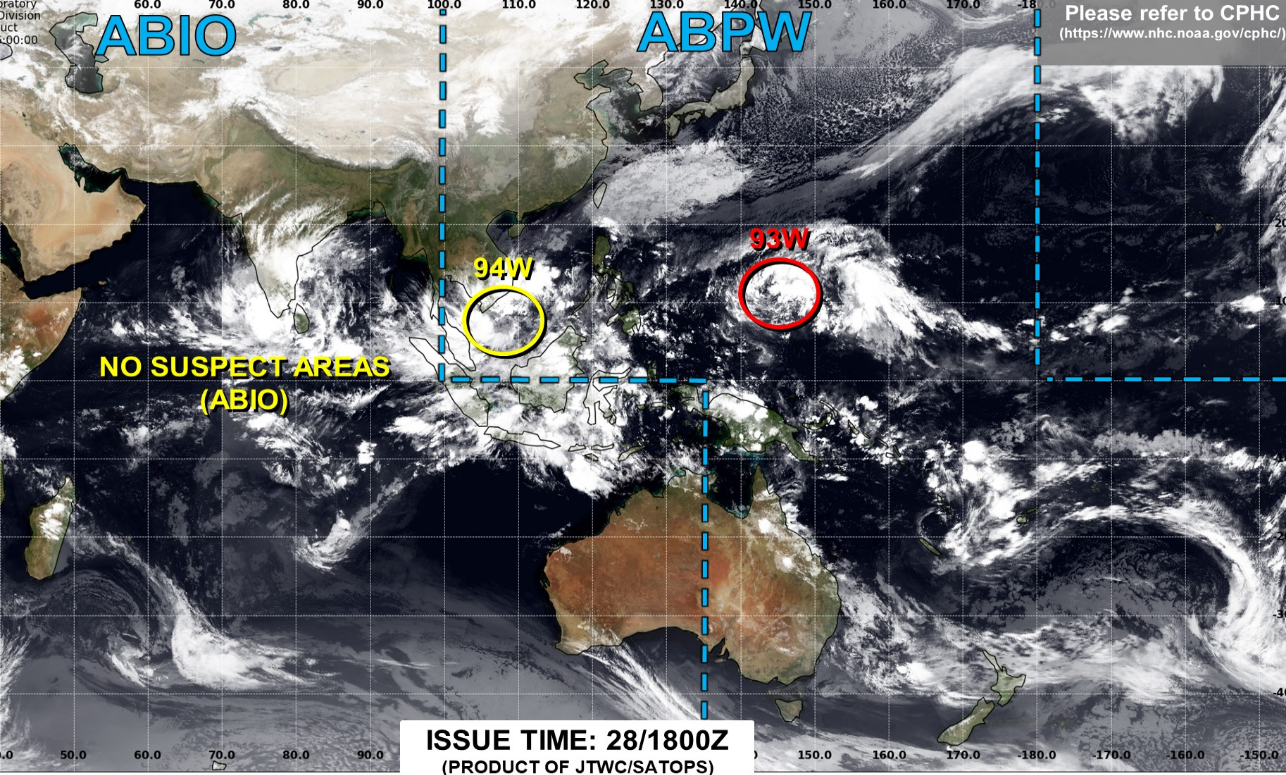
I fell way behind on this thread, but here is my still semi-bearish outlook. If something can go wrong in the West Pac, it will. Typhoon is dying in the South China sea, no phase. Models have remnant low hooking up with a Japan system, but that's no phase. Per Carvers (my negative take at least) it just jacks up the +ABNA... Which might hook up with the raging -NAO forecast by January. Except the damn -PNA is relentless. We've seen this rodeo before. Models will struggle much worse than normal (both directions) as Arctic air enters the central US. Now the -NAO is amped up on tilt both CFS and GFS weeklies, with some handoff to West Coast / Southwest ridge; however, we've also seen those false alarms before. I simply don't believe it. SER remains stubborn, and it jives with a locked in -PNA. Worse yet, MJO convection wants to reset over that dreadful Maritime Subcontinent. Color me skeptical of a cold pattern change. My interpretation of the West Pac satellite image

-
Just wait and see how it shakes out. I agree models are trying to figure out a cold shot. MJO continues to look favorable. TC is forecast over there, but other convection should continue - vs TC saps all energy. Yea Grit is in a whole other weather universe east of the Apps. He can have his ice storm. Ice requires such a specific set of circumstances here that there's no reason to forecast it outside of 3 days. Over there, different story with CAD pattern recognition. As for blocking yes a west based -NAO is required, esp with this stubborn -PNA. Yeah a Rex in the GOA would change things.
-
NWP has turned less hot for the 11-15 day. Do we want to ride the emotional roller coaster? Convection is all over the West Pacific. Couple invests; however unlike last time, other deep convection is present. Maybe it will shake out well for some cooler temps in the Southeast US. Blocking tendencies are noted in the extended guidance, but it's probably a function of the MJO. Can it verify?
-
I'll take the bait. Bored enough to kick around ancient analogs. January 1985 was the freezer of record here. Fortunately a method to deliver such cold is climatologically extinct. Snowcover can barely get south of the Canadian border anymore. In the 1980s snow would cover the ground points north, keeping the cold air very cold. Bare ground now allows rapid modification into the South. Even January 2014 would be bad enough. Heat pump bill Jan. 2014 was 2X any hot AC month. Still, power price is less volatile than that of natural gas, so the heat pump is good most winters. Yeah @Mr. Kevin later rather than sooner might be a good call for cold. 2023 maybe?
-
Pro Tip: Don't live in Siberia. Weather is arguably worse than the political climate. MJO wants to make progress. Oop! Another Invest in the West Pac. How will it mess up the progression and keep SER in place? Confession: I am really salty because we wanted to ski NC right before Christmas. Climatologically dumb move, but it sounded fun while kids on break and before the Christmas crowds. Hope in the 11-15 day has a little pattern recognition help, all else equal. That kind of cold likes to ooze southeast. We'll see.
-
I still like Friday... for another weather disappointment.
-
Tennessee only produces during marginal setups. Moderate risks bust. As for winter, now a +GLAAM screws up any MJO attempt at normally colder phases. Continue SER indefinitely. Weeklies offer an opening right after Christmas. Sometimes those go faster. While I'm jawboning flamethrower, of course I'm hoping for a Christmas miracle.
-
Next weekend (Dec 11) went to crap in a hurry. Positively tilted and south, not ideal for severe. LOL even talking winter wx in the main thread. Can't make up this stuff!
-
Models have tried and failed to move the MJO east for weeks. Matt Hugo is missing badly. I'm in a contest on who's more bearish, Kevin or me. I'll use the ECMWF monthlies as an excuse to go even more bearish, AN temps all remaining months of winter. I am mostly joking, but the clusters are pretty consistent. Oh wait, I'm not kidding. Updating my long-range for work. Yeah I'm warm every week the rest of the calendar year and every month of core winter. Regarding the SCANA index, it's been a miserable failure for North America recent winters.
-
BAMWX totally blew the latest MJO call. Models have been consistently moving convection east too much, and it has not budged. In fact it is very strong over the super hot (SER) Subcontinent. Also got ground truth from International friends the storms are bad there. I have to go with a 4-6 week much warmer than normal temp pattern which takes us through the New Year. That chart is more bearish than any stork market chart. Mele Kalikimaka is Merry Christmas in Hawaiian.
-
Sunday Dec. 5 does not interest me. Lets try teeing up that ECMWF on Sat. Dec. 11 Winter is stuck on a containership off the coast of Calif. - Facebook meme
-
Clean sunny SER! Just kidding. More likely Plains ridge with NW flow, still sunny. Variable east Tenn. Warm Mid-South. MJO resets warm phases Maritime Continent. Typhoon sapped the West Pac energy. Got more action IO which will propagate to Indonesia. Bearish Southeast US. Now if a trough can get into the Plains later in winter the Mid South still has a shot. I threw in the towel southeast Tenn. I can do that it's now meteorological winter. NWP is a bearish blowtorch this morning. Why summarize it? Kindergarten taught us if we don't have anything nice to say... Did I already break/shatter that rule?
-
Fall/Winter Banter - Football, Basketball, Snowball?
nrgjeff replied to John1122's topic in Tennessee Valley
Great Valley warm nose looks legit. Oh yeah I also watched OSU at Michigan earlier. Seems MSU had the better snow. When there's no chance of snow locally, one watches it on TV. -
I'm punting the cold. Joining Mr. Kevin and the bears. Teleconnections have shifted sharply warmer as the Pacific typhoon develops. SSW is actually not in the cards anyway. PV gets jostled by some warmth in the Northern Hemisphere; however, said warmth is not close enough to the pole. Active strato may be helpful later in winter, but that's a total wild card. Plus, studies do indeed show a stronger correlation with Eurasia cold. NA can get it delayed. Maybe we get a cold shot around Christmas and again in January. I give up on any 4-6 week cold pattern though. Maybe used it up already.
-
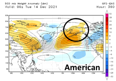
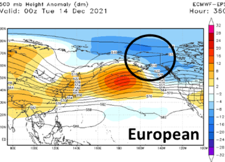
THIS from Carvers above. We had a good MJO thing going. Trying for SSW at the same time reminds me of an old Wall St saying. Bulls make money. Bears make money. Pigs get slaughtered. Don't be greedy! Strato confusion is mixed with tropical Pacific confusion. Both Japan and the US Navy have a typhoon developing in the West Pac. Curves away from the Phils mercifully. Talk about a royal cluster F in the extended forecast. GEFS and EPS do different things with that energy. Here is the sharp disagreement between the GEFS and EPS. Top European cluster (plurality not majority) at the surface is still cool Southeast with very warm Plains. GFS is warmer but 1/3 of its clusters are even colder Southeast - makes sense with the charts above. Bottom line. Enjoy the volatility!
-
Fall/Winter Banter - Football, Basketball, Snowball?
nrgjeff replied to John1122's topic in Tennessee Valley
Iron Bowl I kept waiting for Auburn to block a Bama field goal or extra point. There's an interesting history there. First Iron Bowl OT in history was truly a gem though! Regulation was not as entertaining though. I watched the snow come down at the Michigan State game. Since it does not snow here anymore... -
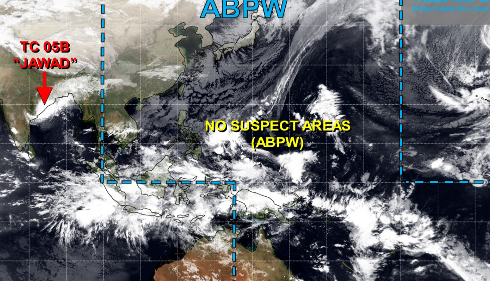
GFS is particularly good at those 50 mb and 10 mb levels and it's been talked about for over a decade in the energy industry. Much as we make fun of it in the troposphere, we notice the stratosphere and plan accordioning. Don't pay attention to commodities this week due to market conditions. Pay attention to that Strato. OK the MJO is confusing right now due to Invests out there. Models got hung up on the yellow one in a mild area (Southeast US). Now they are starting to pick up on red, which is new but of greater interest. Just gained HDDs this afternoon. Big overnight gain (Colder Southeast US) would not surprise me tonight. Red Invest is over a cold signal area. https://www.metoc.navy.mil/jtwc/jtwc.html Joint Typhoon Warning Center is useful year-round for drilling down MJO propaganda.

-
La Nina is notoriously volatile and yes the models will suffer. La Nina is still basin-wide. Weekly wiggles in the regions are noise compared to the overall signal. Meanwhile the negative trending QBO could be bullish; however, a fake-out would not be helpful. Invest in the West Pac has models confused going warmer. I'd give that a another couple days. Could flip right back cold Sunday or Monday.
-
Getting bullish December vibes. First the keep it simple method, November was cold. Trend is one's friend in most cases. Second the GEFS just caved to the colder EPS at 12Z Friday. Now to the non-model evidence. MJO push is already strengthening the jet stream off Asia. It's usually strong this time of year, but it's really amped up now. ENSO with -GLAAM is a cold December pattern with southern storm track especially with the MJO coming out of the West Pac. Members know I'm usually pretty skeptical about cold; however, I have reasoning when I'm skeptical. No reason to be blindly mild. Right now the current trove of evidence supports a cold weather pattern.