nrgjeff
-
Posts
3,903 -
Joined
-
Last visited
Content Type
Profiles
Blogs
Forums
American Weather
Media Demo
Store
Gallery
Everything posted by nrgjeff
-
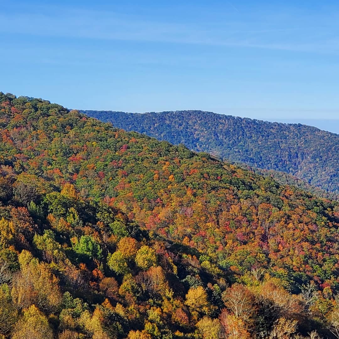
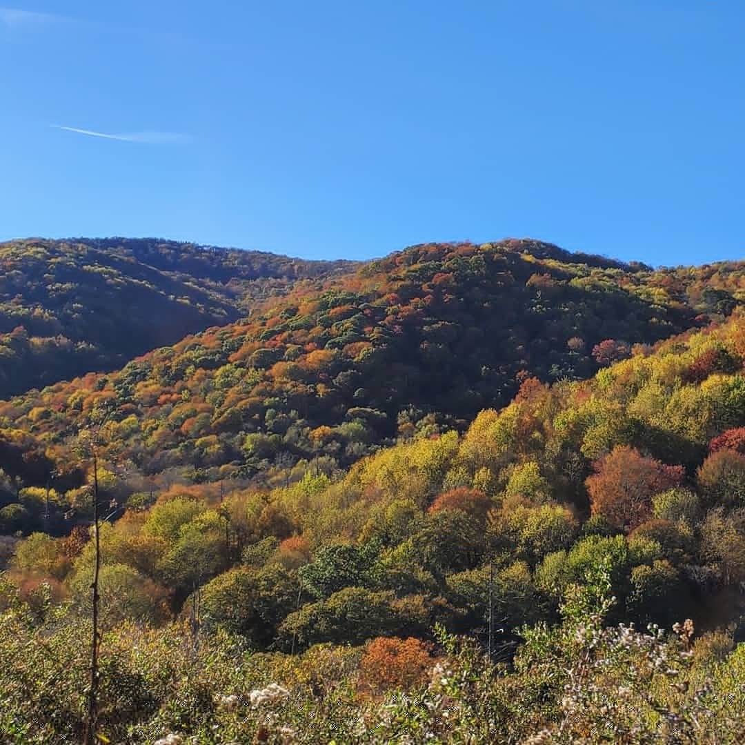
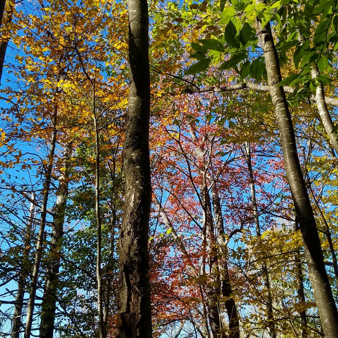
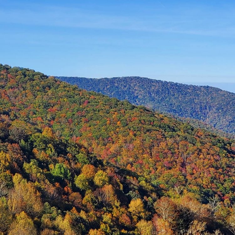
Chattanooga was lit this weekend. Enjoyed a couple nice local hikes.
-

Wild Speculation for Winter 20 -21
nrgjeff replied to Holston_River_Rambler's topic in Tennessee Valley
European Monthly charts are pretty warm most of winter. December has a small Southeast US cold cluster; but, the Western Canada source region is on fire. February and March are endless SER. Hopefully the overnight severe is up in Hoosier Alley. January appears to the best shot at a good secondary pattern. Clusters are below. The 48% has blocking and a path to deliver at least seasonably cold Arctic air. That'd do it! I'm assuming these are available to the public now. If not, please to not re-share. Certainly no commercial use. OK for academic use.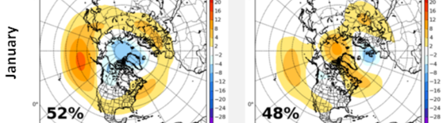
-
Veterans Day 2002: Now that's what I call Interesting! Though I can't find archived upper air charts. I infer from the orientation of the front that the trough was positively tilted, and still produced a High Risk. Do we laugh at the Euro and GFS or take that a little more seriously? I'll opine for real later this week.
- 168 replies
-
- 3
-

-

-
- leaves changing
- temperatures
- (and 2 more)
-
Fall/Winter Banter - Football, Basketball, Snowball?
nrgjeff replied to John1122's topic in Tennessee Valley
Actually @AMZ8990 my home barometer was sluggish. However I was too. Needed extra coffee. Four days overcast, or the pressure drop? Sun was nice by afternoon. Then the evening squall with CF almost impressed me. Usually don't get those with the Plateau slowing down things. It was just enough to remind me of a Plains cold front, though a milder version. Still, thumbs up! -
I was sleepy AS so maybe the pressure, lol. My home barometer is an old one so did not really keep up. I should upgrade. Couple Halloween decorations face-planted. We will rebuild.
-
Wild Speculation for Winter 20 -21
nrgjeff replied to Holston_River_Rambler's topic in Tennessee Valley
Skimming Ray I like it. He's basically mild. However I agree that the secondary or tertiary pattern this winter opens the door for upslope - between bouts of SER or other meh. If so the local ski areas really need the business after covid and mild wx last year. My interpretation of the Ben Noll graphic, dominant +ABNA which is not great but also not SER. It's AN heights Siberia and Canada, with BN heights Bering Sea and right here in the Southeast US. However the source region is on fire in Canada including western Canada. 38 and cold rain Chattanooga. Take it to the bank! I am also watching pressure anomalies in Siberia, China, Canada and the USA. If the northern ones are AN and the southern ones BN, bullish cold unsettled. If the northern is BN, locked up cold air, we're probably AN. I believe the snow extent stuff is absolutely worthless without pressure and height context. Two ways to get AN snow and they have very different outcomes. 1. Low press Siberia and Canada achieves AN snow due to unsettled weather. Stays AN mid-latitudes with cold locked up. Bearish. 2. High press Siberia and Canada achieves AN snow due to cold but little qpf. BN press/heights mid-latitudes invite that cold to spill down in later weeks and months. https://psl.noaa.gov/map/clim/glbcir.quick.shtml I check this site for pressure etc. https://climate.rutgers.edu/snowcover/ is the old Rutgers snow site. Bottom line: No pressure context makes Cohen's snow stuff worthless. Much respect to him, and he's a nice guy in person, but I need pressure and heights. Last few days have been the bullish set-up. However 7-day and 30-day smoothed charts are quite bearish. If I can't have snow, I guess look fwd to severe. -
Maybe we can get some severe weather going around Veterans Day. Did somebody say record high temps? And also a West / Plains trough approaching. You'd think by November no odd closed low or TC would get in the way, but you never know in 2020. Otherwise I do believe warm is our background weather pattern due to La Nina. Expect typical or greater La Nina volatility though. Warm water off the Pac NW Coast invites troughs over the Continental US. Plains trough and SER cage match smack down. Don't forget folding chairs and microphone stands.
- 168 replies
-
- 5
-
-

-
-
- leaves changing
- temperatures
- (and 2 more)
-
Fall/Winter Banter - Football, Basketball, Snowball?
nrgjeff replied to John1122's topic in Tennessee Valley
Olga Oct. 25-29, 2019 brought TS strength winds to West Tenn. Believe it was still designated TS or STS but greater than TD at the time. Back to current: Zeta caused a couple Halloween decorations to face-plant. We will rebuild, lol! PS. Dewpoints of 70-72 are quite frankly unacceptable in late October. -
Well now my friends, Zeta may still be a minimal tropical storm when it crosses from Alabama into North Georgia. That means steady wind from North Georgia up the Southern Appalachians, especially the Smoky Mountains. Forget about the Cat 2 noise on Twitter, though it's not totally out of the question. Main issue is the forward speed. With the help of the mid-latitude trough, Zeta will scoot right along relative to earlier tropical systems. Though weakening quickly, a quick 15-hour ride from the Coast means it can still be tropical storm strength. Usually I'm not a, goodie we got a TS guy; however, I'm bored. Can't see any interesting severe wx, at least not during the day. Hopefully the WS goes to Game 7.
- 168 replies
-
- 3
-
-
- leaves changing
- temperatures
- (and 2 more)
-
Fall/Winter Banter - Football, Basketball, Snowball?
nrgjeff replied to John1122's topic in Tennessee Valley
GFS and NAM have dews lower than the ECMWF. Enough rain on Wednesday would help prevent the higher dews advecting north. 70+F really is cruel and unusual punishment this late in the year. -
Wild Speculation for Winter 20 -21
nrgjeff replied to Holston_River_Rambler's topic in Tennessee Valley
Latest European weeklies line up with the tropical convection for the last forever. Except for next week's cold front, it's mainly warmer than normal weeks. Especially weeks 3-6 have a screaming +ABNA pattern. That's not super warm here, but no way to deliver cold. Warmest anomalies are north and west. I would think it's the secondary pattern. Would last until about Thanksgiving. Then the primary pattern in La Nina would be that stubborn SER. Neither is really cold here, which is not a surprise in La Nina. Guess I'm saying the same thing over and over. Mainly warm. Hope for a well timed miracle. One of those Plains cold outbreaks bleeds southeast correctly timed. -
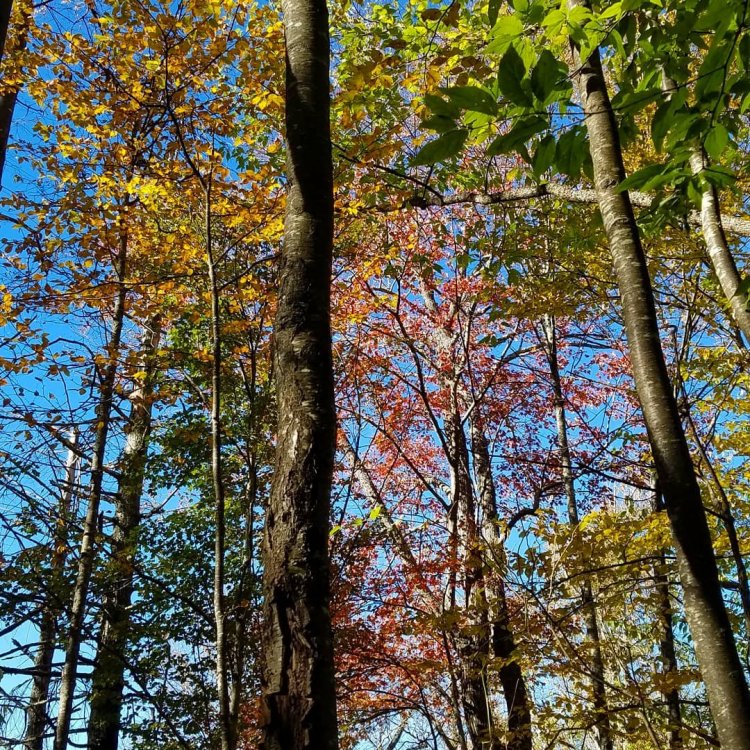
Yes this weather is simply perfect. Looks to continue for several days (except maybe Saturday) as all global models slow down the Big Front. Only the ICON is still cold before Halloween; but, it's an outlier. Looking for more leaf viewing this weekend. Probably about 3,000 FT. We jumped a bit early last weekend, but still made the best of it. Got the blue sky pics which might be elusive this weekend. However sometimes bright overcast is good in photos, with minor 'help' on the PC, lol! Halloween weekend could be good lower elevations if the front just prior is not too windy. Also note the early Fall time change this year Sunday November 1.
- 168 replies
-
- 5
-
-
- leaves changing
- temperatures
- (and 2 more)
-
Fall/Winter Banter - Football, Basketball, Snowball?
nrgjeff replied to John1122's topic in Tennessee Valley
Let's do it! I'm happy the Challenge will go forward despite the pandemic. Kansas at Tennessee will be close. We might not know the winner for a couple weeks. Just kidding! Last I checked the Champions Classic is still on for late Novie. However I think some of the bigger early season tourneys are cancelled. Big 10 fb starts this weekend. LOL that two of their teams have such high probabilities for the BCS. Really? They haven't even played one snap yet! -
Next year we will do the Blue Ridge on Fall Break. Seems to go 7-10 days earlier than Tennessee or even the Smokys, timed with fall break. Those pics on the Parkway are stunning. Even the cloudy day the trees pop out. Here is Saturday October 17 on the Cherohala Skyway. Pictures are taken from just inside NC at about 4,500 FT. Higher was well past peak. Lower was green. Past weekend only a thin 500 FT section was peaking. We enjoyed that elevation quite well. I suspect the 3,000-4,000 FT area will be great this coming weekend on the Tennessee side.

-
Wild Speculation for Winter 20 -21
nrgjeff replied to Holston_River_Rambler's topic in Tennessee Valley
My only thoughts are Bearish. What's new right? North Pac certainly helps with cold air delivery - just not here! OK the Mid South maybe. But I forecast a winter of malaise for the actual Tennessee Valley. Farther northeast (MRX/TRI) could do ok. I have strong doubts anything of note will happen HSV to CHA. I know it only takes one bowling ball, but nah. Forecast model failures recently point to the trend. SER likes to hang on, even w/o an upper ridge. Just stay warm. Eventually cold air will bleed southeast a few times. Then I'll forecast drizzle and 38 for KCHA. -
Fall/Winter Banter - Football, Basketball, Snowball?
nrgjeff replied to John1122's topic in Tennessee Valley
Sports has been a disaster from Volunteer football to Braves base running. The only thing harder than being a Vols fb fan is being a Kansas fb fan. Poll. What's worse. 1. GFS extended 2. Kansas football 3. Atlanta base running Kansas and Tennessee fans look to NFL/Pro or await basketball season, and pray it's not covid crazy. -
Fall/Winter Banter - Football, Basketball, Snowball?
nrgjeff replied to John1122's topic in Tennessee Valley
Ensembles and Weekies have settled on the hurry up and wait solution. Cold front coming. Just wait another 10 days. We can trust the timing. Halloween cold front is usually money. -
Oh I saw a webinar yesterday about SSW and related events including early season, last warning, and something called reflection. I'm sorry I can't share it. However the reflection case resembles the ABNA Asia Bering Sea North American pattern, which is also related to charts Jax shares including Asia and North America. All 3 tie in. Good stuff! Reflection is both horizontal and vertical. The vertical requires the stratopause be in a certain state. Warm energy from the West Pac Tropics pumps up a ridge in eastern Siberia. China gets cold. Pattern reflects a wavelength downstream over North America. Canada mild USA cold. At the right wavelength looking at Asia weather charts can help with USA forecasting.
-
Fall/Winter Banter - Football, Basketball, Snowball?
nrgjeff replied to John1122's topic in Tennessee Valley
Eddie Van Halen passed away. I'm going to be pretty bearish for a few days. Much above normal temps this winter. No snow. Nocturnal tornadoes. -
Looks like MDT Nina. Oh yeah Jax our posts are three weeks apart. Definitely a different sequence. At any rate, tee up a SER most of winter. Cutters. Severe wx. SOS
-
Fall/Winter Banter - Football, Basketball, Snowball?
nrgjeff replied to John1122's topic in Tennessee Valley
That's good news, except for more of those snow clown maps on Twitter, lol! Euro at times gets even more carried away than the GFS, depending on the vendor algorithm. Baseball wild card was fun. Games all day like March Madness. Still have a ton of sports overlapping now with the NBA Finals, MLB playoffs, and lots of football. Ironic that after missing sports for several months, we now enjoy a huge sports period that started with the NHL and NBA playoffs. Now college football is full steam ahead. -
Fall/Winter Banter - Football, Basketball, Snowball?
nrgjeff replied to John1122's topic in Tennessee Valley
Yes 1989 was the winter of record back in KC. All-time record low was set two nights in a row at -23 F. However that's for MCI since 1973. I think Downtown MKC has a colder older record, but that'll stand due to the urban heat island now. Apparently the 1989 wavelength was fairly big if Kansas and Tennessee followed the same pattern, vs cutter city over here. The blowtorch second half was the same too. Wow back in the days we had full latitude troughs for everyone! Other big years 1985 was more over here, cold but nothing spectacular in the Central Plains. 2000 was more there than here. I was about to put this in Fall; then, realized it's winter. All the out-of-region stuff I'll go Banter. Now in 2020 I'll go stubborn SER for at least southeast Tenn. I could see northeast Tennessee doing fine in La Nina. Then when the trough is Central US, a nice Mid South winter hammer. Everyone but CHA and HSV. Barring a one-day miracle. -
Around 3:30 Eastern today Friday a tornado touched down around Myrtle Beach / North Myrtle Beach. Plenty of stills and videos on Twitter since it's a tourist area. #scwx will bring it right up.
-
Yeah the +ABNA does have some blocking as Carvers notes. However the Alaska / northwest Canada source region is on fire. +ABNA can get it done down here locally with split flow, but that's not usually good for Region wide fun. Plus I'm just a very skeptical bear. If I can find just one reason to go warm, against 3 cold, I'll go warm. It is the South. Everything lines up, or cue up Toad the Wet Sprocket 1992, something's always wrong. Given a decent La Nina and QBO fail I'm seriously warm winter at work, no joking. However fall leaf season looks superb!
- 168 replies
-
- 3
-
-
- leaves changing
- temperatures
- (and 2 more)
-
European weekly charts line up with the cooler than normal outlook through the first 10 days of October. However, it ends there. Rest of the weeks are slightly warmer than normal. AN heights stretch from the West across Canada. Return of the +ABNA. Cancel winter? Well, this is the fall thread. Good news is the next few weeks will be good for leaves turning on time. Just avoid any wet wind storms. Early next week is not an issue. Same system in 15 days would be awful.
- 168 replies
-
- 3
-
-
-
- leaves changing
- temperatures
- (and 2 more)