

nrgjeff
-
Posts
4,255 -
Joined
-
Last visited
Content Type
Profiles
Blogs
Forums
American Weather
Media Demo
Store
Gallery
Everything posted by nrgjeff
-
The case for tough love and watering cut-off in July is made. Lawn is deep green again. I watered in June for the early season, but only every 3rd day. Make it root deep. Even if we flash drought (unlikely now) it should be fine.. Sod is the exception. Must be babied all season long. I have to guess sod in this area is in good shape now. I have standing water in low spots. What a regime change!
-

Spring/Summer 2022 Medium/Long Range Forecast Discussion.
nrgjeff replied to John1122's topic in Tennessee Valley
Complaining occasionally works. Got a thunderstorm last night. And now...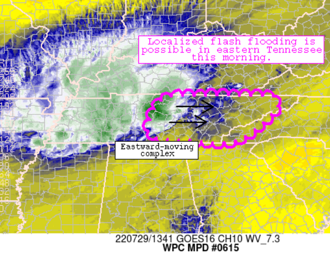
-
Spring/Summer 2022 Medium/Long Range Forecast Discussion.
nrgjeff replied to John1122's topic in Tennessee Valley
Yes @8283 El Nino Baby the Plateau, Walden's Ridge and the like are a whole other world. Winter they get snow while we get cold rain. I have come to the conclusion that a significant tropical system will be required to break the Eastern North American ridge before Labor Day or even mid-Sept. Otherwise it's gonna be a cruel something until October. Short-term addition: 18Z guidance Thursday for Friday has.. You guessed it! Dry friggin fropa for KCHA. -
July in Nashville is more typical of Houston suffering. Chattanooga is almost as bad. Memphis with more 100s reads like a DFW CF6. HSV is somewhere between Houston and DFW weather. This is ridiculous. I know we were due but this sux. PRELIMINARY LOCAL CLIMATOLOGICAL DATA (WS FORM: F-6) STATION: NASHVILLE MONTH: JULY YEAR: 2022 LATITUDE: 36 7 N LONGITUDE: 86 41 W TEMPERATURE IN F: :PCPN: SNOW: WIND :SUNSHINE: SKY :PK WND ================================================================================ 1 2 3 4 5 6A 6B 7 8 9 10 11 12 13 14 15 16 17 18 12Z AVG MX 2MIN DY MAX MIN AVG DEP HDD CDD WTR SNW DPTH SPD SPD DIR MIN PSBL S-S WX SPD DR ================================================================================ 1 96 73 85 5 0 20 0.00 0.0 0 3.8 12 180 M M 4 18 180 2 96 74 85 5 0 20 0.47 0.0 0 5.4 20 170 M M 6 18 26 170 3 93 75 84 4 0 19 0.45 0.0 0 2.9 29 20 M M 6 138 38 60 4 94 75 85 5 0 20 0.19 0.0 0 4.0 24 170 M M 5 18 32 180 5 99 76 88 8 0 23 T 0.0 0 5.1 16 180 M M 5 38 21 180 6 97 79 88 8 0 23 0.79 0.0 0 6.5 17 170 M M 5 13 27 160 7 95 76 86 6 0 21 0.45 0.0 0 4.7 22 310 M M 7 138 37 320 8 99 75 87 7 0 22 0.44 0.0 0 5.7 24 50 M M 4 13 33 50 9 92 73 83 2 0 18 2.34 0.0 0 6.5 31 10 M M 8 138 40 20 10 91 72 82 1 0 17 0.00 0.0 0 7.7 17 20 M M 6 24 10 11 92 70 81 0 0 16 0.00 0.0 0 2.6 10 60 M M 1 15 110 12 95 74 85 4 0 20 T 0.0 0 7.4 18 360 M M 5 25 350 13 90 71 81 0 0 16 0.00 0.0 0 4.4 12 360 M M 6 16 310 14 93 67 80 -1 0 15 0.00 0.0 0 2.2 10 40 M M 3 14 110 15 94 71 83 2 0 18 0.00 0.0 0 3.8 13 30 M M 5 17 360 16 94 73 84 3 0 19 0.00 0.0 0 4.6 15 180 M M 5 19 180 17 92 75 84 3 0 19 T 0.0 0 7.9 35 140 M M 7 35 140 18 85 72 79 -2 0 14 0.49 0.0 0 4.5 15 210 M M 8 13 24 210 19 91 73 82 1 0 17 0.00 0.0 0 5.6 15 180 M M 5 22 210 20 99 78 89 8 0 24 0.00 0.0 0 8.8 16 210 M M 5 26 210 21 95 76 86 5 0 21 0.01 0.0 0 6.1 14 360 M M 6 3 23 10 22 98 72 85 4 0 20 0.00 0.0 0 3.7 10 40 M M 2 8 15 100 23 98 77 88 7 0 23 0.00 0.0 0 5.9 14 170 M M 1 20 140 24 96 77 87 6 0 22 0.00 0.0 0 8.0 16 200 M M 6 22 210 25 94 76 85 4 0 20 0.40 0.0 0 5.9 18 290 M M 8 13 28 290 26 94 75 85 4 0 20 0.07 0.0 M 6.2 16 320 M M 7 3 27 360 27 96 76 86 5 0 21 0.00 0.0 M 7.8 20 180 M M 8 26 180
-
Spring/Summer 2022 Medium/Long Range Forecast Discussion.
nrgjeff replied to John1122's topic in Tennessee Valley
Oh yeah this is a bad year for new sod. Established lawns recovered with the rains after the 4th of July. Sod is just so needy until it roots deeper. I also have little faith in much rain. Today the ARWs/NSSL had phantom rain again. NAM/HRRR are Dr. No short-term and right. Maybe Friday or over the weekend. Note to the forum this is a south of I-40 problem, Chattanooga back toward Memphis. When is fall? I miss football! -
STL got under the train echo from hell. Classic back-building scenario WPC covers in MDs. Since we are so bored in the summer doldrums, maybe we should meet up at the site of that radar echo. Finally @PowellVolz that's some nasty damage, summer Marginal Risk micro/macro-burst things. Like the Ukraine fire hydrant though, whether is coincidence or planned.
-
Spring/Summer 2022 Medium/Long Range Forecast Discussion.
nrgjeff replied to John1122's topic in Tennessee Valley
Chunks of northern Middle and East Tennessee are in the WPC excessive rainfall outlook the next two days. My how things change. Gotta love the Tennessee Valley. About the heat. Fades middle of the week through next weekend if no sharp model changes. More thundershowers. About the following week to start August. Oh wait back in Kindergarten they said if you don't have anything nice to say... -
Yeah @Knoxtron probably a large group of birds taking off. If it was 12 hours opposite (evening) I'd go bats, especially if a cave is in the area. Morning is probably birds.
-
You will like it here. Waldens Ridge gets snow while we are stuck at 34 with cold rain in town. Sooo often!
-
My yard gets tough love starting in July. About July 4 I declare my independence from watering, lol! Lawn was pretty tired before rain last week. Getting there again, but it should rain today. By now it's learned to root deep or suffer. Tough love wins in the long run. Also good to see some posts. Thought everyone died of heat stroke.
-
Spring/Summer 2022 Medium/Long Range Forecast Discussion.
nrgjeff replied to John1122's topic in Tennessee Valley
ECMWF weekly UPDATE: After the turd balance of July, ECW want to back off to normal August in the Southeast. They still torch the Plains and Midwest; so, some of that heat will bleed in here at times. Gonna need a barf bag!
-
My early thoughts. Travel will be required to see good snow. What's new in the South?
- 30 replies
-
- 2
-

-

-
- winter preview
- snowfall
- (and 2 more)
-
Spring/Summer 2022 Medium/Long Range Forecast Discussion.
nrgjeff replied to John1122's topic in Tennessee Valley
Looks like the core of the heat ridge wants to head out West for much of the rest of July, but could return to the Midwest late month. Would love an order of the Sunday CFS, normal through Aug. However global wind and others hint we are not done with AN heat in the Southeast. Hoping to get more rain showers while the ridge is centered out West. Guess we were due for a hot summer. -
Fall/Winter Banter - Football, Basketball, Snowball?
nrgjeff replied to John1122's topic in Tennessee Valley
We probably need a new second half of 2022 Banter thread. Big college sports news rolling in, with conference shake-ups likely. Big 12 absorbing some Pac 12 is a sharp shift from previous speculation of the reverse. We take! SEC snagging some ACC would be big news. Makes some sense with I'm guessing more FB money in the SEC. Also talk of UNC going Big 10 which is a head scratcher. Duke UNC? Well, money would explain all of the above. Just have to unravel that path. -
Drought at my house is ending. After 2-3 dry weeks, missed twice. Then our luck turned. Four days in a row of at least a good downpour - two of which included steady rain after. Temps still look AN the coming week, but not as strong as prior weeks. Precip will be hit and miss of course.
-
Fall/Winter Banter - Football, Basketball, Snowball?
nrgjeff replied to John1122's topic in Tennessee Valley
I have watched USFL football. Nice to have it on weekends again. However I am counting down to NFL and College. -
Spring/Summer 2022 Medium/Long Range Forecast Discussion.
nrgjeff replied to John1122's topic in Tennessee Valley
Unfortunately the heat this week will be more South concentrated than I imagined last week. Humidity will be lower, but temps higher. Combo probably still is lower heat indices than last week. Good ol' Southern tricky front ushers in beautiful high press a few days; then, upper ridge builds back over and hot! Looks like AQ advisories for some metros. If it's not humidity it's haze. Global wind and some MJO forecasts hint at the ridge migrating West in July. However with normal temps rising, and slightly AN forecast, sensible weather may not ease up much. Also the stubborn PNA and ABNA which want to stay about where they are. Perhaps those more specific forecasts will be less accurate than the GW and MJO. -
Same here Friday. Wind blew, and no rain at my house. Lawn was hanging in there, but this week is going to be ugly no matter how much watering. Will water lightly and force the lawn to limp through.
-
Spring/Summer 2022 Medium/Long Range Forecast Discussion.
nrgjeff replied to John1122's topic in Tennessee Valley
Welcome home! Your Oregon Coast gale might beat my Kansas shelf cloud this year. Now back to hot humid life in Tenn. Next week looks like the SER tries to reload, even if under a passing GL to Northeast trough. Been a while since we've got sustained SER in summer tbh. Maybe week 3 will be more sane. Models want to retrograde the Midwest ridge. Even if week 4 is back to AN temps, it has a more spread out feel vs concentrated ridge. Think positive, or at least less crazy heat. How long until college football? LOL! -
We had a sub-par storm chase in the Plains. Definitely should have stayed here for the meteors. Plus I know the daytime hiking weather was also fantastic here.
-
Monday I agree that Minnesota is the primary target (MN Storms). Chasers with the time and energy should get up there. We will probably target the south end in Neb. Kan. Note a frontal occlusion is forecast between targets Monday; so, it's one or the other. South target the DL and CF separate again. Also the front from the North low may drape in such a way to act like a stationary front east of the South TP. Sunday night rain may also deposit outflow boundaries for Monday. Finally Monday LLJ will be strong South too; so, it should anchor such east-west boundaries. Good for Monday Madness. Again the day could be more historic up in Minn. We have to play south target in case the chase goes into Tuesday.
-
Observed sculped low-top structure on the Cumberland Plateau between Spencer and Sparta, Tenn. However no lightning. Almost reminded me of tropical remnants. Except it's 20 degrees cooler up there (Thursday vs a tropical day lower elevation). The surface wind was howling though.
-
Sunday and Monday are clear eastern ND and western Minn. Checks air fare to MSP. Details 3rd paragraph. First Saturday, I would target just behind the boundary intersection near the Black Hills. Roads are not ideal, but terrain can help even if the SPC fades the set-up. Black Hills are behind the cap (good) - and boundaries (meh) so, it is a pure terrain play. Sun/Mon both feature double short waves and double surface responses. Yes 3-4 days out, but models are not going to blow that basic type of forecast. Trouble is northern waves drag up warm 850 Ts ahead of southern waves. Gosh, like forecasting snow busts in the South! OK back to the Plains. Nebraska gets boundary intersections. Excellent CAPE is under worst cap. Easier cap is right on or behind boundaries. You know, I don't like right on boundary initiation any better than just-in-time moisture. Eastern North Dakota and Minnesota enjoy a better set-up IMHO Sun/Mon. Frontal waves and perhaps warm front intersection with more traditional boundaries. Less cap. Still good CAPE. Said boundaries promote local SRH. Someone on another forum mentions June 17, 2010 but who knows. Saw after making my thoughts. Tuesday (or as early as Monday Neb.) could still go Nebraska Kansas, but LLJ moves out as main trough ejects. That's faster for Tuesday, and takes away a solid chase day. Bottom line: Sunday and Monday look like the kind of days that can work out eastern ND western Minn. Saturday junk will deposit other boundaries for Sunday. Rinse and repeat Mon. Maybe Tue.
-
Boundary intersection in Kentucky. Goodie that terrain! Sarcastic. Second chance if Gulf front can lift north enough to intersect pre-frontal trough in Alabama or Georgia. Doubtful. Hoosier Alley is probably the preferred location, but I'm not interested enough to go into their Regional forum, lol.
-
Even before seeing MRX severe discussion, MRX mention of mountain wave means the LLJ will be there. Unless Gulf MCS cuts it off, but looks OK. Dews will be there. It's late May not March; so, MCS does is much less a deal killer here. If Mississippi is 5% Wednesday, Alabama is certainly 5% Thursday. That's some easy pickings. Day 2 update would not surprise me; but, they might wait until Day 1. Thursday the 700 and 500 mb winds are not as straight south as Wed. More SSW. 200 mb is south, so some VBV; but again late season, those minor problems are not deal killers like in March. CAPE looks skinny, esp low levels, so heating will have to over achieve. LI is definitely there; so, just low level CAPE has to come in. Look for pre-frontal trough Bama to East Tenn. Perhaps outflow intersection with it. Today and tonight rain will provide plenty of boundaries.
