nrgjeff
-
Posts
3,903 -
Joined
-
Last visited
Content Type
Profiles
Blogs
Forums
American Weather
Media Demo
Store
Gallery
Everything posted by nrgjeff
-
THIS from Carvers above. We had a good MJO thing going. Trying for SSW at the same time reminds me of an old Wall St saying. Bulls make money. Bears make money. Pigs get slaughtered. Don't be greedy! Strato confusion is mixed with tropical Pacific confusion. Both Japan and the US Navy have a typhoon developing in the West Pac. Curves away from the Phils mercifully. Talk about a royal cluster F in the extended forecast. GEFS and EPS do different things with that energy. Here is the sharp disagreement between the GEFS and EPS. Top European cluster (plurality not majority) at the surface is still cool Southeast with very warm Plains. GFS is warmer but 1/3 of its clusters are even colder Southeast - makes sense with the charts above. Bottom line. Enjoy the volatility!
-

Fall/Winter Banter - Football, Basketball, Snowball?
nrgjeff replied to John1122's topic in Tennessee Valley
Iron Bowl I kept waiting for Auburn to block a Bama field goal or extra point. There's an interesting history there. First Iron Bowl OT in history was truly a gem though! Regulation was not as entertaining though. I watched the snow come down at the Michigan State game. Since it does not snow here anymore... -
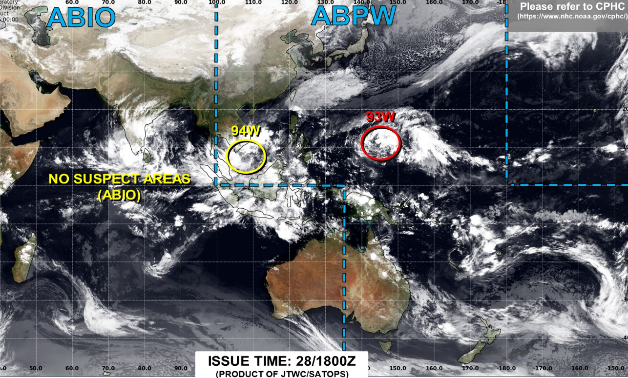
GFS is particularly good at those 50 mb and 10 mb levels and it's been talked about for over a decade in the energy industry. Much as we make fun of it in the troposphere, we notice the stratosphere and plan accordioning. Don't pay attention to commodities this week due to market conditions. Pay attention to that Strato. OK the MJO is confusing right now due to Invests out there. Models got hung up on the yellow one in a mild area (Southeast US). Now they are starting to pick up on red, which is new but of greater interest. Just gained HDDs this afternoon. Big overnight gain (Colder Southeast US) would not surprise me tonight. Red Invest is over a cold signal area. https://www.metoc.navy.mil/jtwc/jtwc.html Joint Typhoon Warning Center is useful year-round for drilling down MJO propaganda.

-
La Nina is notoriously volatile and yes the models will suffer. La Nina is still basin-wide. Weekly wiggles in the regions are noise compared to the overall signal. Meanwhile the negative trending QBO could be bullish; however, a fake-out would not be helpful. Invest in the West Pac has models confused going warmer. I'd give that a another couple days. Could flip right back cold Sunday or Monday.
-
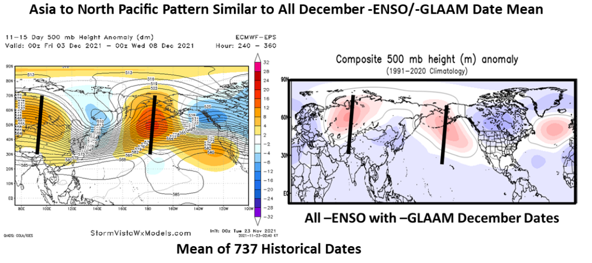
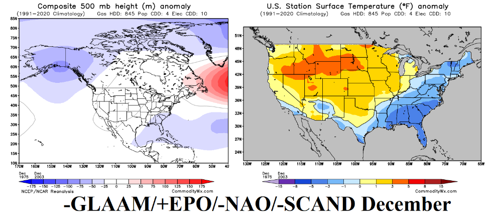
Getting bullish December vibes. First the keep it simple method, November was cold. Trend is one's friend in most cases. Second the GEFS just caved to the colder EPS at 12Z Friday. Now to the non-model evidence. MJO push is already strengthening the jet stream off Asia. It's usually strong this time of year, but it's really amped up now. ENSO with -GLAAM is a cold December pattern with southern storm track especially with the MJO coming out of the West Pac. Members know I'm usually pretty skeptical about cold; however, I have reasoning when I'm skeptical. No reason to be blindly mild. Right now the current trove of evidence supports a cold weather pattern.
-
Here's another bullish take for our region, but the national picture if flipped compared to my previous teleconnection mixer. I trust we have no commercial lurkers here. Please do not share outside this sub-forum. Happy Thanksgiving!
-
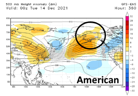
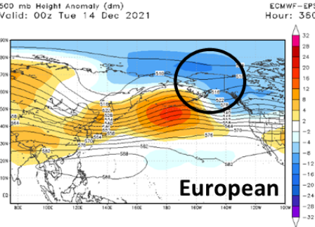
Yeah I'll take the EPS over the GEFS and we'll be right 9/10 times. Euro is markedly colder than the GFS. Can we get a December 2008? Note the large sample size, though it's days not weeks or months. Do not share outside this Region. Also the ABNA is somewhat steady with Aleutians Bering Sea ridge, and troughs in China and parts of Eastern North America. ABNA impacts shift a little south compared to summer (Canada) into the USA. ABNA had been reverse in summer, warm in Canada and mild in the Southeast US. Current mirror image Mongolia / Canada (and it does shift around) would be cold Southeast US. So while I'm bearish winter overall, the 11-15 day overnight flip is more evidence of a volatile pattern in the mid-term. Hopefully @Carvers Gap is right that we could get the December cold and a reload in January - before the January thaw that holds and ushers in that warm Feb.

-
Yeah it's time to start the bearish winter thread, haha! Looks like December will start mild. Perhaps if the MJO wakes up or a Western US ridge pops up, cold can be delivered. GOA and NAO seem to check out after week 2. However Nina climo would favor some sort of cold in December. I have to favor toward Christmas, given this mild 6-15 day forecast. Full basin La Nina is a pretty solid signal for a mild back half of winter. Though La Nina is notoriously variable.
-
It's a full basin La Nina. I expect our best chances first half of winter. Look for greater SER frequency and strength second half.
-
Fall/Winter Banter - Football, Basketball, Snowball?
nrgjeff replied to John1122's topic in Tennessee Valley
One has to like the Vols performance against UNC. Villanova is notoriously hard to beat, at least of KU haha! Yeah I expect Tennessee in the second weekend. -
Fall 2021 Thread (September, October, November)
nrgjeff replied to Carvers Gap's topic in Tennessee Valley
Yeah it looks volatile up and down temps. NAO may hang in there longer than progged on the weeklies. However the GOA low is likely, given the MJO pulse died an ugly death. IO Invests sapped it. Big question is a West Coast ridge (USA not Canada). Models missed that for the Mon-Tue cold coming in. 10 days ago models were meh. Now we have a 90th percentile November cold shot coming. So while the Arctic and Pacific battle it out, the US West Coast may be a tie breaker. Do we torch, or are models missing another West Coast ridge? -
Fall/Winter Banter - Football, Basketball, Snowball?
nrgjeff replied to John1122's topic in Tennessee Valley
Tennessee vs Villanova Saturday! Oh yeah college basketball season is rolling. Kansas looks good too, but our next significant game is a couple weeks away. So this weekend it's go Vols! @Mr. Kevin did you feel the Arkansas tremblor on Thursday? All, who woke up for the lunar eclipse this morning? I'd intended to say something about it ahead of time, like shocker clear skies for an astronomical event here! Long duration deep partial lunar eclipse extended the lunar version of the diamond ring. It was truly gorgeous! Eclipses never get old. We are now inside 2.5 years to the next jaw dropping, awe inspiring, total solar eclipse. Gonna be a longer drive but I'll be there! -
Fall 2021 Thread (September, October, November)
nrgjeff replied to Carvers Gap's topic in Tennessee Valley
More Invests in the Indian Ocean sap the convection. No wonder the MJO goes into the circle of death. -NAO can do heavy lifting, and it's negative enough to do so, but only temporary as Pacific influences cause undercutting. December 2005 is right up with with December 1989 for full winter than full cancel. Speaking of cancel all the weeklies have canceled December. I wouldn't worry about the 3-6 week forecasts though. Actually yeah I would. If anything can go wrong, it will. -
Fall/Winter Banter - Football, Basketball, Snowball?
nrgjeff replied to John1122's topic in Tennessee Valley
Wow @John1122 you are braver than me. I try for the stealth exit, but honestly it probably sees me. So you skip right to the be loud phase? I figure any common sense move promotes survival. If you can only remember one bear rule, just don't F* with mamabear or her cubs! -
Fall 2021 Thread (September, October, November)
nrgjeff replied to Carvers Gap's topic in Tennessee Valley
The MJO indeed stalled last week per looking at the historical index and also satellite movies. We have another Invest in the IO which could throw yet another wrench. However - key difference - is that convection is already in the West Pac. No surprise models have turned colder for the 6-15 day. -
Fall 2021 Thread (September, October, November)
nrgjeff replied to Carvers Gap's topic in Tennessee Valley
Looks like SER all winter. Just kidding! Joe Bastardi mentions 1989 and 2000 Decembers. He has not been right about anything in years. Yeah November looks really choppy as Carvers writes just above. I concur. That pattern with Bering Sea ridging allows AK to go BN heights November, mild here. However past La Nina years that pattern November have evolved into a colder Southeast US solution by December. Just not Joe B cold, lol! -
Fall/Winter Banter - Football, Basketball, Snowball?
nrgjeff replied to John1122's topic in Tennessee Valley
Reacting to bears is a good question. Smoky Mountain NP (and other national and state parks) has guidelines posted. Here is my not so complete memory. 1. Walk away from the bear (obviously). Don't run though. It'll go better just walking. If it's in your path, then a long detour is required. 2. If it charges (unlikely unless mama bear defends cubs) then try to become bigger with tree branches or anything to scare it. Bang pots and pans if you have camping gear. 3. Like all animals (sharks snakes etc) it's more scared of us than we are them. Walking away almost always works. We've seen bears a few times and have been able to just walk away back toward from where we came. In one case it was 90 degrees to our side, but far from the trail. We were quick, but kept it to a walk back to the car. Saw coyotes close to town in Chickamauga Battlefield. They crossed the trail. We decided to cut short the excursion. They either never saw us or did not care about us. We have also seen small sharks while snorkeling. We simply swam the other way and it was uneventful. Glad we don't look much like fish! -
12Z Monday GFS and NAM guidance for Thursday 11/11 hint at a lifting boundary in South Georgia. Looks south of Atlanta so I have to post here vs my home Tennessee Valley subforum region. Juuust enough CAPE (all that's needed in the South) accompanies adequate speed and directional shear. LLJ mainly well north is the limiting factor. However any mesoscale wave could keep it going in Georgia. ECMWF has not started, but its overnight runs support the scenario. If the LLJ hangs in, South Georgia could have strong to severe thunderstorms on Thursday.
-
Fall 2021 Thread (September, October, November)
nrgjeff replied to Carvers Gap's topic in Tennessee Valley
However there's a disturbance in the Force. Invest in the Indian Ocean could disrupt the MJO cycle. That'd cause the cold to hang up in the Midwest above a suppressed SER. Otherwise the moderate La Nina should promote cold intrusions into the South eventually. If the MJO pulse survives the Indian Ocean shenanigans, the cold may be sooner rather than later. Finally, a persistent -WPO is forecast. In past La Ninas with -WPO November cold did kind of hang up; however, Decembers were very cold into the Southeast. Something to watch. -
Fall 2021 Thread (September, October, November)
nrgjeff replied to Carvers Gap's topic in Tennessee Valley
I'll be happy to meet you half way. Warmer than normal OK. Can we go AN severe weather too? Anyway weekend forecasts have turned colder in the 6-15 day with excellent agreement and some sub-seasonal support. Models themselves are nearly unanimous in the 6-10 day. The tight clusters in the 11-15 day are unusual, and welcome to cold fans. Back to the sub-seasonal. Yukon ridges like to be stubborn this time of year, once re-established. Big MJO pulse about to come out of the Indian Ocean into the West Pacific. That's a cold 6-15 day signal! If this verifies, November will average colder than normal. Correlation with balance of winter is good, but no promise. I would favor that cold balance early. First January thaw could end the party, but I'm getting ahead of reality. November is the primary objective. -
Fall 2021 Thread (September, October, November)
nrgjeff replied to Carvers Gap's topic in Tennessee Valley
Cold returning after the mild interlude next week really would not surprise me. See if we can book a BN average for November. ECMWF monthlies came out today. First look, I grunted winter canceled after December. Chart is seasonable Dec. January and February composites are mild. However splitting into clusters, it's actually fairly close to 50/50 each month. There's a warm cluster; and both months, there's a pretty good cold cluster. In other words it's TBD. If November can end cold going into December, it could hold for a few more weeks until the first January thaw. Though not every year, a cold November is a bullish correlation for winter. If we come back Monday to a mild forecast and November crap-out, I'll sign off until March, lol! -
Fall 2021 Thread (September, October, November)
nrgjeff replied to Carvers Gap's topic in Tennessee Valley
Good morning @Mr. Kevin I will never dispute a warmer than normal forecast. Trend. But I try to offer hope. Pacific teleconnection roundup is robust! Do not share outside our region though. Valid after Day 15, but not really a forecast.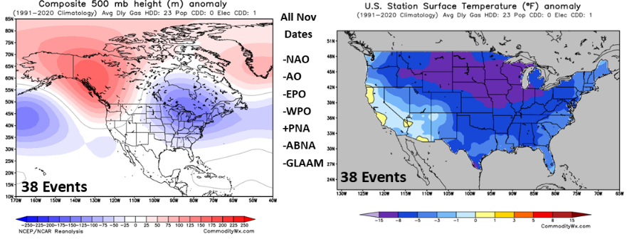
-
Fall 2021 Thread (September, October, November)
nrgjeff replied to Carvers Gap's topic in Tennessee Valley
We might be able to get that to work courtesy of the ABNA however the wavelength is a little squirrelly like you note. This is the European weekly composite of weeks 5-6. Historically those weeks offer zero forecast value but it's fun to look! It's not far from the coldest group of historical years. Again, just garbage. Should I move this to banter? There is the China tie-in so will put it here.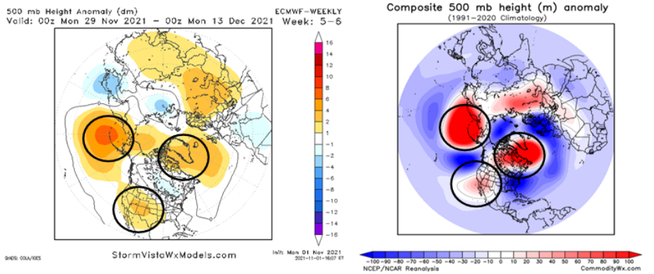
-
Come on down to Chattanooga. Always warmer here. Mountains surrounding the city are colorful up to 2,000 FT. By the weekend 2K+ will be past peak. Lower elevations look to tee up nicely again this year. Have not been to the Plateau which is usually cooler than even Lookout Mountain. Going to guess Lower Plateau great color 1,000 to 1,500 FT and maybe through the weekend. If we can just get decent weekend weather.
- 167 replies
-
- 2
-

-
- frost
- cold front
- (and 4 more)
-
Lovely day in Chattanooga with temps in the 60s. This is a blessing on days like today. I'll be whining about it when we are rain and 38, while y'all are snow.
- 167 replies
-
- 4
-

-
- frost
- cold front
- (and 4 more)