nrgjeff
-
Posts
4,261 -
Joined
-
Last visited
Content Type
Profiles
Blogs
Forums
American Weather
Media Demo
Store
Gallery
Everything posted by nrgjeff
-
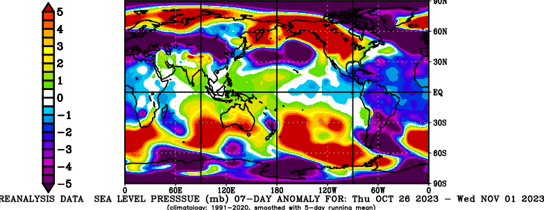
SST trends are somewhat encouraging RE the PDO. Snapshot still isn't great, but the trend. (not shown) And look what's back. HP at the pole. Even better, it's driven by a Ural Mtns high. Then the snow pattern is doing what one would expect. Ural high. Stormy south of Siberia. I love it baby!
-
To those wondering about November surface T forecasts. This is a mega-ensemble CFS/GEFS/ECMWF weeklies. I'm sorry if it violates the hate speech rule. Warm and totally uninspiring.
-
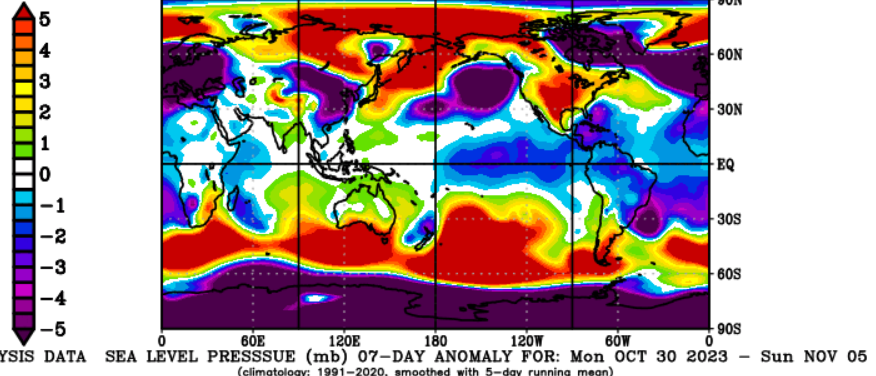
Unfortunately my Halloween post turned out not to be a treat. Pressure chart shows trick-f**k. That's a mild signal. Siberia Alaska HP runs its course. Top of the Pole is already LP - mild signal.
-
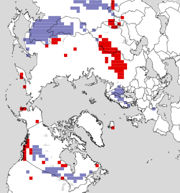
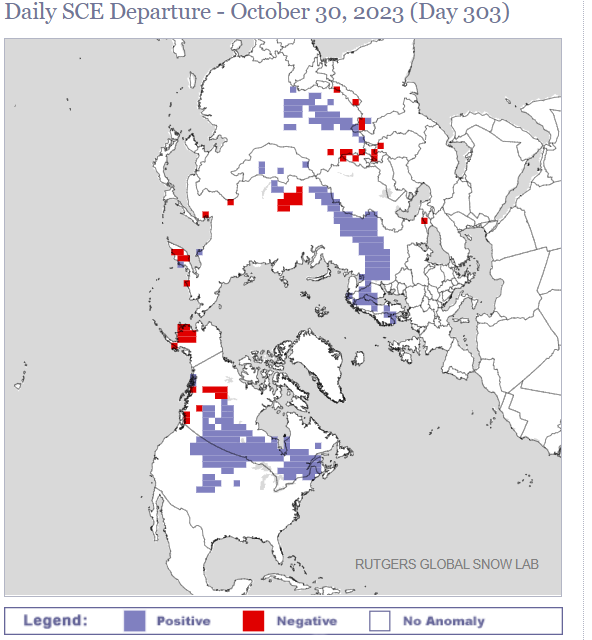
Rutgers snow chart has me about has happy as I was when Kansas beat Oklahoma. Winning! Sea level pressure (not shown) is AN in Scandanavia, Alaska, and eastern Siberia. Also helpful BN in mid-latitude China.
-
Cold forecast for Halloween has a good track record recent years. Kids trick-or-treat. Parents drink more to feel warm. Rinse repeat.
-
Need to bump one of John's thoughts. I think I first put this in the wrong thread. October does not have much correlation with winter. November definitely has a nice significant correlation with winter. It's not perfect, but odds are with November. Then in the longer-term, starting to get the look in the Arctic. AN surface press could deliver mid-latitude cold.
-
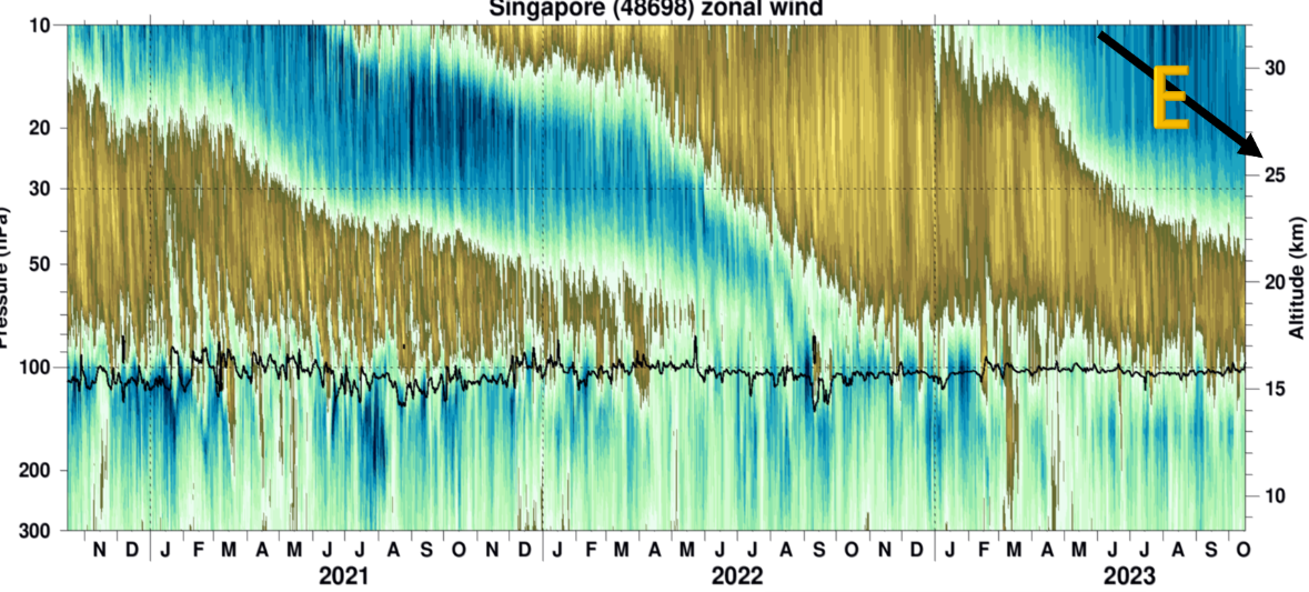
Well it's below 30 mb which is encouraging. Head fakes (2019-2020 fake is not shown) typically die above there. Fingers crossed.

-
Need to bump one of John's thoughts. First mine, October does not have much correlation with winter. November definitely has a nice significant correlation with winter. It's not perfect, but odds are with November.
-
Yeah @Carvers Gap I like your mid-winter thinking. Bottoms out. The continuation scenario would surprise me. QBO is tough to forecast through. I just watch trends, and the actual wind anomaly up in the strato. Years that fail, the strato easterly anomaly fails to meet the tropo. Cautiously optimistic. or at least fingers crossed, ha.
-
We can't even get a tropical system to help out around here. Looks like a deep South slider *. Next front from the north looks like another under-performer here too. I think we can recover the drought if November rain does not fail. Cue up your G&R, ha! * Let's not do that precip shield way south crap in the winter.
-
If that QBO is for real, and not a head-fake down, my outlook on winter shifts from warm. All else equal, robust basin-wide Nino is mild. The most recent weeks the ABNA has favored mild. However, we had months from spring to mid-summer with the other drivers that kept our region and points north and east mild at times. My going thinking is that the most recent pattern is the new warm one. A properly falling QBO into mid-winter would shift my thinking, and call for a reversion to that cooler pattern.
-
Yeah this sux (below). Hopefully we can snap out of it. I agree with @Carvers Gap that the Atmo assumed Nino state months ago. We are now in stubborn SER season. Trough next week looks dry, but that's also typical October. Perhaps in November the STJ will become active. And if that means more cloudy days buy coffee futures, lol!
-
It's probably more accurate than some long-range models. I'll allow the wooly worm!
-
That's the East Brainerd black hole. @PowellVolz @dwagner88 same deal IMBY
-
Yeah @Holston_River_Rambler I watched robust thunderstorms break up on their way into my location Wednesday eve. East Tennessee lower elevations are stuck in a dry pattern. Parts of Chattanooga got rain, but the ol' East Brainerd crap-out was in full effect. I expect similar disappointment today in southeast Tenn. Option 1 is morning thunderstorms dissipate early afternoon. Option 2 they go into North Alabama. I see no win for southeast Tenn. Oh crap, this is the long-term thread. Recent years confirm strong and super Nino are mild. We had one strong go cold with some QBO PDO and blocking help. Otherwise it's warm. Peer reviewed research shows a strong statistically significant warm bias.
-

Why east winds for so long in the Gulf?
nrgjeff replied to Rockem_sockem_connection's topic in Southeastern States
Looks like the Eastern CONUS weather pattern is all blocked up. High press is stacked at all levels. Upper lows anchor either side in an almost spring-like Omega. Annoying on many levels. -
Might not be a surprise, but from MRX. Should be fine to share public info. Below are some interesting trends for September I wanted to share with you: Chattanooga · Only 0.09" for the month · Unless 0.32" is reached (unlikely), this will be the 3rd driest September on record and the driest since 1919 Knoxville · Only 0.35" for the month · Currently at the 5th driest September on record, but rainfall is more likely in the next couple of days Tri-Cities · 0.79" for the month · Currently at the 5th driest September on record, but rainfall is more likely in the next couple of days
-
The QBO is indeed falling. I like a -QBO trend even better than static -QBO. Trouble is two of the last three failed to descend properly, leaving us in the mild pattern. In the medium term for October we do have some high press from Greenland to the Arctic north of Scandanavia. Need that to build over Siberia to Alaska. Unfortunately that's all the good news I have. Long-term the risk of Super Nino is mild across the board. At this time with the falling QBO I tend to favor equal risks. Mainly the back half of winter could get cold. If the QBO fails then I'm mild Dec-Jan-Feb. Wake me up for severe!
-
Just now seeing this. The Tennessee Valley region indeed includes North Alabama and North Mississippi, per the Tenn. River. Then if you go TVA territory, much of east-central Mississippi joins. What the heck? We adopt all of Alabama and Mississippi! I discuss it all when time permits. Usually, I'm hankering for a chase. Plus it's to my west, which is of personal interest even when not chasing. Unfortunately, sometimes work duties prohibit time on the board. I might be biased, but I believe the American Weather Tennessee Valley is the best Dixie Alley discussion on the Internet. One could debate the Plains Internet spots, but for me it's no contest in the South.
-
Well the CFS and ECMWF weeklies are just about total opposites around here. Lovely! Must be shoulder season. Most of the Pacific tropical cyclone activity is joining the jet stream, vs pumping up a China (ABNA) ridge. I have to favor the cooler CFS. In contrast to the GFS/Euro debate, we've seen the CFS win out about as often as not.
-
Hoping for another great foliage year. RE the East ridge. Do you know what I really want to come of that? Trough Midwest, severe weather of course!
-
Euro is relying too much on classic El Nino. I'm more with the climate trend and CFS. Blowtorch. No hope.
-
Interesting, because lower elevations have been hotter than forecast. It's frustrated the hell out of me tbh!
-
Fall/Winter Banter - Football, Basketball, Snowball?
nrgjeff replied to John1122's topic in Tennessee Valley
KC Chiefs won't have home field if they even make the playoffs. Time to focus on college. Go Vols! -
Mood after looking at weather data Carvers is probably right unfortunately. Early 'canes will just act like warm fronts. Maybe we can get a break in mid-Sept.
- 295 replies
-
- 4
-

-
- severe weather
- frosts
- (and 5 more)