nrgjeff
-
Posts
4,258 -
Joined
-
Last visited
Content Type
Profiles
Blogs
Forums
American Weather
Media Demo
Store
Gallery
Everything posted by nrgjeff
-
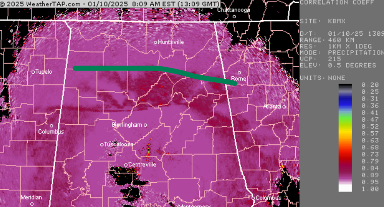
 Light snow in eastern Chattanooga. Getting to the high end of light, but not yet moderate. Thick dusting to quarter inch already. Light snow started around 7am ET. Correlation Coefficient still shows a county or two buffer between Tennessee and rain/mixed. However it is creeping north. Need the defensive line to hold! I believe Hytop and BMX are scanning different elevations at the mix line (green). BMX matches surface obs better which is good 'cause its green line is farther south.
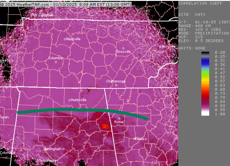
-
I'd feel better if DFW had not changed to 33 and rain. Just happened to be following them since early week. This 546 line may bite us in the ass down in southeast Tennessee. It's just too high. Yeah GFS has WAA winning a little too much. Nashville can relax now in my opinion. Lock it in 4 inches. Probably 6 and locally 8 in. Drier snow will help totals. Isentropic lift blasts northern Middle Tennessee without warming up too much aloft. Gonna give Tellico the medal for best sports metaphor. Esp. going into the CFB semis tonight. You know what? I think the analytics say go for it. Perfect!
-
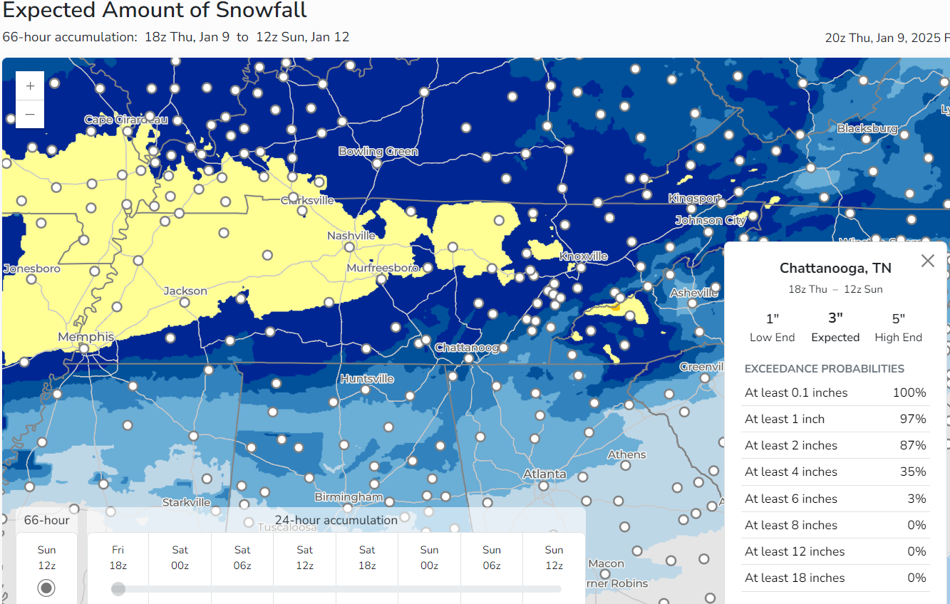
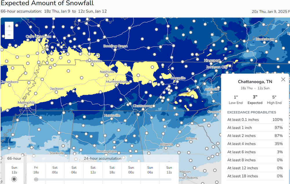
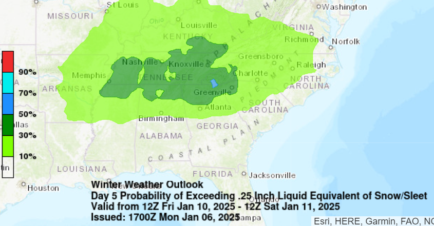
That's almost the entire TVA Service Territory. Overall this is a true Southern winter storm. Re the MRX low-end and high-end charts. That's anything from a depressing warm surface to all-snow big-time isentropic lift for hours. We're gonna find out soon! NAM red alert below. Can I give the NAM the Finger?
-
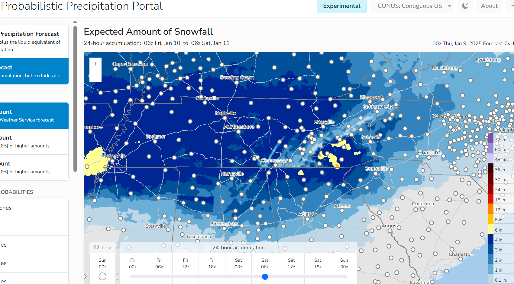
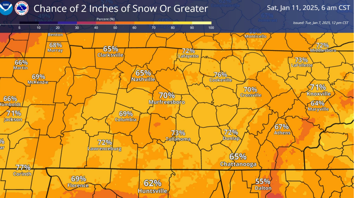
WPC winter page updated in the proper direction. Chatty looks really reasonable. JC is similar but 2 in. low-end. Kingsport is similar with a 6 in. high-end. So yeah, keep giving us the Finger! Then they have KnoxVegas 2-5-8 must be nice. Range is from questionable temps to isentropic bomb. They have NashVegas 3-6-7 which seems aggressive. Tighter range more confidence though. Experimental NWS Probabilistic Precipitation Portal to explore on your own from the WPC winter page.
-
They're literally giving us the Finger. The low-end slide is even worse. On the bright side, the high-end slide hammers everyone with 6-8 inches including Chatty - an all-snow isentropic bomb scenario.

-
Yeah Shawn I think that's why we're getting away with high 1000-500mb thickness. Dallas staying all snow would boost confidence here in 546 thickness land.
-
Heavy banding will be the driver this storm. No real TROWAL this set-up. The front WAA and isentropic uplift should be the main thumper. Just not too much NAM. Keep WAA just right. That said some areas up near TRI that might miss the front end have a chance upslope. Maybe not a back side trowal, but regular upslope. PS that's still close enough for a TROWAL cartoon though.
-
View from 30,000 FT or say the good ol' 1000-500mb thickness, models improved overnight 06Z and now 12Z rolling out. Chatty was looking bad above 546 and close to 552 but now its 546 with several hours of 543. While 540 helps me sleep better, 543 could work if cold is in place. All the above should help the Downslope areas too. Partial thickness looks better too. That 850-700 mb level that was way too warm a couple 18-00Z runs has improved. It's still a little warm, and I'd feel better lower, but it'll work. Plus the true DGZ just above it should be golden. 850 and surface Ts are pretty much available everywhere and self-evident, mostly good. I think the snow charts rolling off also speak for themselves. Forecast has improved. MRX already raised Chattanooga from that 1" propaganda to a more reasonable 2-3 inches. Honestly that's what I think given current data. If we get more cooling at the low levels we could still get 4+ here. Then I think many areas will score 6 inches just south of I-40. Questions linger south of I-81 just like in CHA. Like John says, heavy bands will determine a lot too. Cautious optimism has returned. I didn't post it, but I was actually worried last night. This morning I believe everything is on track!
-
Yes the ARW and FV3 are in reasonable agreement and along the lines of thinking earlier today. NAM can do some weird stuff at 48-60 hours. The other two have their bad days also, but when two of three agree I'm not too worried about the outlier. Then of course the globals are still probably better until Thursday morning. I said I was done but I'm up watching Kansas. I need a KU come-back 2nd half, the globals to hold the line, and the ARW/FV3 to be right. Goodnight and think snow.
-
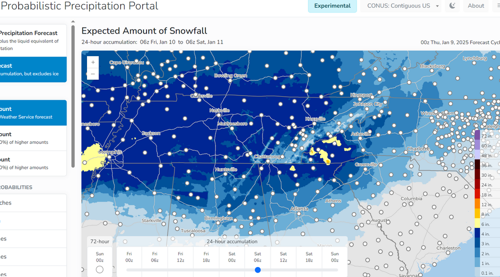
I was going to say now that @Stovepipe has joined the conversation, we can have a real winter storm. Game on! And this chart makes no sense. WPC winter wx page Experimental Probability Precipitation Portal. What's Georgia got goin' on? I want a serving or three!
-
For Chattanooga, any mention of last January is hate speech, lol! I swear I'll shatter my device on the concrete driveway. Think Office Space fax machine 2025 tablet version. 18Z roundup didn't get any warmer by partial thickness or surface Ts. Even full thickness is no change. NAM is still spewing warm hate. That said 18Z NAM shows juust a wee bit of 850-700mb partial thickness improvement. GFS has the most snow. Euro may be the happy middle. Euro 18Z is a tick up for Chattanooga snow. MRX probability charts in their EM briefing all went UP 2" 4" 6" but the most likely forecast went down. That's not totally illogical given the data. Warm nose risk is there. At the same time greater QPF is available if temps stay cold. That's about it for me today. Happy forecasting to those who celebrate the 00Z and 06Z. Cautious optimism continues. My device will survive. The kids will be sledding on a snow day Friday.
-
Chattanooga debacle is always believable. If the column gets any warm bubble we're toast. Indeed I can vividly remember a couple cases. Cut totals. Then re-raise. I'm not blaming them or anyone. Just seen it before.
-
The NAM is taking over! Maybe it's the delay Warning until next period. Could be the ol' down then back up. We'll see. I have not seen WPC update lower with all their probability-based products. We eagerly await those. MEM is still..
-
Hot Pink WS warnings are coming to that map. I would think this afternoon. Definitely west. Yes the QPF has trended up because the stream phasing has improved with most model runs. Seems just right for snow, kind of a 50/50 balance of northern and southern streams - like Eagle Fang and Miyagi-Do karate.
-
The forecast vertical cross sections with time (not distance) that @Knoxtron posted on the previous page are excellent. The immediate surface won't hurt Chatty. That warm bubble at 900 mb would be a disaster during the event, but that's mostly before precip. Column is forecast to cool. One can see that really well esp. TYS and TRI. By main event time the column is cool enough. The perfect storm track is why we can accomplish that, rather than have warm air bleed down and up from the bubble and the ground. Barring a disaster everything should work out. OK I'm signing off for the night. Happy forecasting! I love those charts this storm. Most of the time they'd have warm air expanding and piss me off, lol!
-
Biggest issue with the MRX CWA is that Chattanooga and southwest Virginia might as well be on different continents in a borderline temperature event. It's hard for me to imagine all that snow up there when it's partly cloudy and 42 here. Then I'm sure it's hard for the WFO to imagine Chatty getting blanked when they've got 2 inches and still going at the office, and SW Va is pushing 5 inches. That's not even getting into the frustrating microclimates. Typical borderline temps make everything worse! Difference this time is cold air should be in place. A few hours above freezing is acceptable if we drop back below 32. Just nice we're not sitting in Chattanooga starting at 45 degrees and stuck with downslope from 7 out of 8 directions. Friday is going to be so nice.
-
RGEM is hate speech, lol! I get what it's showing. Thankfully the American 18Z models are opposite. Both the GFS and NAM partial thickness situation improves on 18Z runs. The 850-700 mb thickness, always my concern, drops as the core WAA isentropic lift comes through East Tenn. That's exactly what the Dr. ordered! I want lift, dynamic cooling, and no warm nose BS
-
Morristown does not show it on their public graphic, but one can infer some East Tenn downslope from the Nashville slide. Please no. I want everyone to do well. Slide is not for commercial use.
-
Well now. This is public on their page. Nashville is similar in EM briefings. MRX site.. I agree. Though 700 mb is a bit warm -5 vs -10C a nice DGZ sits above that and well saturated. Then 500 mb is the magic -22C. 850/surface is as good as it gets down South. Push in the poker stack baby!
-
Oh my! Anytime it starts with "not to be that guy," "not to be offensive," or "I'm sorry but" then they are that guy, they are offensive, and they're not sorry. That's political roundtable toxic! Southwest Virgnia is 110% this Region. It certainly is by weather patterns. It definitely is by culture - and that's a high compliment. It's an extension of the Great Valley (and sometimes the snow pain), the Blue Ridge, and the Cumberland Gap is still up from the Cumberland Plateau. Geography is king. As for the topic at hand, friends west of Knoxville also had some of that snow band this morning.
-
Looks like wind converges in the lee of the peak. Bernoulli effect both sides. Convergence zone overcomes any downslope. Second example also looks like convergence after wind accelerates over two parallel parts of the River, then converges. Unless it's plain ol' river / reservoir effect. Hopefully Friday we can do better the micro-events, haha!
-
I don't know if snow weenies ever relax, lol! It can be moderate snow with phat quarters but the dry slot could end the party faster than a police raid. This thing looks Miller B more than Miller A. That came up on the last page. Of course our best deal is a true slider which is still possible. Trouble with B is we can get hosed in the handoff. More specifically the 500 mb low hanging so north trashes the partial thickness chart. With low levels 850/surface clearly cold enough, we'll get snow. Trouble is the 700 mb level* and DGZ will be suboptimal during what's usually the best WAA phase (isentropic lift). Comma head should be responsible for most of that snow forecast by WPC and local NWS WFOs. *700 mb is well below freezing, no concern there. Just not the ideal cold. We'll see. Second half of storm could be all systems go. What we need is a good ol' fashioned TROWAL and corresponding shovel graphic or gif, lol.
-
Let's talk severe instead. Come on GFS, I was only joking!
-
NBM and ECMWF are all in line with the WPC. Inject me with more 12Z EC, fewer hand-off complications. If we can reel it in another 36-48 hours of modeling, WPC has pretty good probs this far out! Update: Nashville briefing has 56-60% one inch or greater Friday. Chart is not public yet.
-
After that said system, models try to break the cold. Warm front would make sense after a last over-runing event. Or, you know, there's a strato warming event forecast at the same time. Release or Reload?