nrgjeff
-
Posts
3,903 -
Joined
-
Last visited
Content Type
Profiles
Blogs
Forums
American Weather
Media Demo
Store
Gallery
Everything posted by nrgjeff
-
Best chance of a rude SER is probably days 15-30. Positive global wind could go negative which would play nicely with a -PNA. Until then the Desert Southwest has their even ruder ridge with record highs forecast next week. That keeps us mild. Even weeks 3-4 all models (mid-range and weekly long range) have exhibited a sharp hot bias for us this summer. Continued benign with out a few really hot days is my feeling. Trend is our friend until it ends.
- 295 replies
-
- 5
-

-
- severe weather
- frosts
- (and 5 more)
-
ECMWF and especially CFS weeklies have punted even that one hot week in July. Seems too good to be true, but the mid-range models 11-15 day stayed the same or even backed off. They were never super hot here. Bias corrected that normal 11-15 day is BN temps Tennessee Valley and Ohio Valley. Deep South heat may creep into the Mid-South at times. Barring a sharp turn in the trend, easy ride may continue for East Tennessee. Weeklies are usually only good for two weeks. Steady patterns in peak winter or peak summer can be useful 3rd week; we are peak summer climo. So there's a chance these benign weekly forecasts are right. And we get off easy this summer.
- 295 replies
-
- 5
-
-
- severe weather
- frosts
- (and 5 more)
-
Latest models (if we care) have El Nino peaking early. Then it stays below Super for winter, esp on the EC. Spread includes anything from strong to weak, with plenty of members in the moderate to weak area going into winter. We need to see how things go for several more weeks.
-
We're gonna need these weekly charts to go ahead and be right. That would be great. (Office Space boss voice). CFS and EC both go deep into August, and none blow up a SER. Relatex to Jax's post above, they have the week of the 17th hot, but it's July 17th so.. If those forecasts are right (not usually past week 3) then that'd be it for summer. One advantage is persistence, mostly mild with just a few hot spurts. El Nino and a cranking global wind continue. Then trend is our friend until it ends. Hopefully we can hold onto the mild summer overall.
- 295 replies
-
- 6
-
-

-
- severe weather
- frosts
- (and 5 more)
-
We have the answers. @Jesse from KY Enhanced both Saturday and Sunday. SPC was likely waiting for boundary placement before forecasting corridors of more straight line wind. This is my first time on the board in a while. Work was a whip last week. I was kind of expecting a small 5% Tor Sunday since they did Saturday. Sunday has greater flow aloft, though Saturday did have the more obvious outflow boundary.
-
Regrettably I could not get on here over the weekend. Looks like the Memphis area got slammed on Sunday. Chattanooga had a good line of storms, but no major wind. Yes those MCSs are notoriously hard to predict. High-res CAMs were garbage until the night before. That's actually not bad for summer MCSs. Models just can't get a handle 36-48 hours out like synoptic winter/spring. 00Z so about 18 hours ahead, models got the East Tennessee MCS blowing on outflow out of Kentucky. Models did a little better with West Tennessee a full day and a half ahead because the focal point was a little closer to the synoptic system. In contrast East Tennessee was mesoscale driven by that outflow from previous convection. Fun forecasting.
-
The PDO could start to move with El Nino closer to fall. PDO is currently pretty stubborn to this point. QBO I believe the rate of change is most important. Falling going into winter would be a cooler signal. If the QBO bottoms too early, it could be slowly rising in winter. Super Nino looks super mild to me. I suppose northeast Tennessee and the Mountains could benefit from the storm track. Could be tough getting cold air in place from BNA to CHA and points southwest. Of course it only takes 1-2 systems well-timed with cold, but super Nino winters are usually warm vs weak/mdt Nino.
-
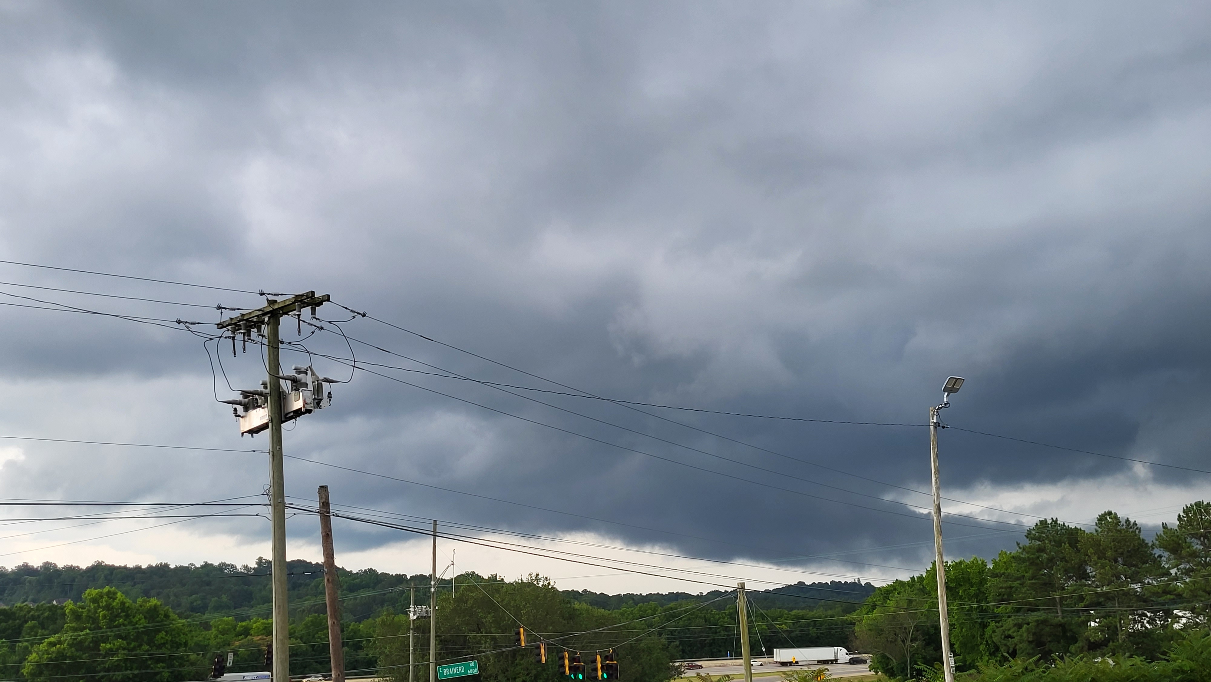
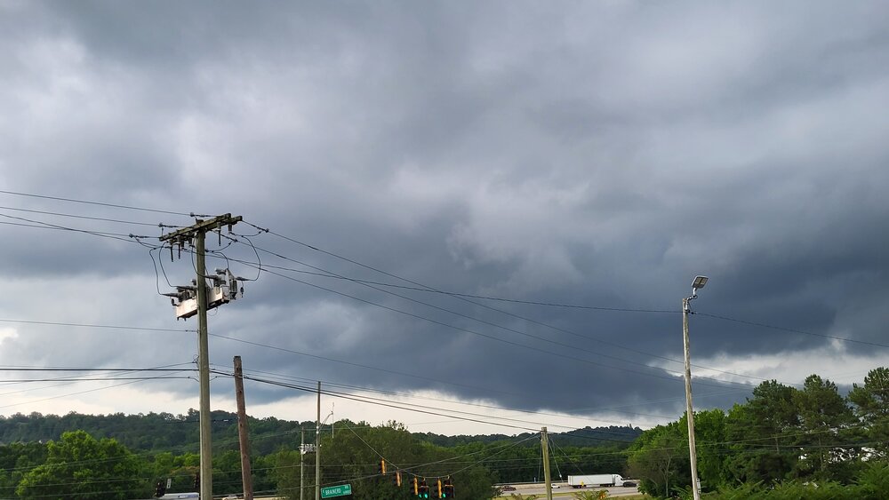
Monday the cells had slight rotation due lingering winds turning with height. Fortunately the turning was not enough, and the speed shear was weaker than on Sunday. I was doing time-lapse towering Cu just for fun near Chattanooga, and discerned some turn but only with the speed-up. It was weak, but still fun to time-lapse. This picture is actually on Tuesday. If you know the area, I was at the I-75 interchange with East Brainerd Rd. Bargain Hut parking lot offers a little perch for viewing, if one does not mind the power lines. The view is not nearly as far and wide as from US Express, but BH was on my way already. I was not chasing, but yeah I stopped for the tail-cloud like feature. No rotation was observed, at least not in real-time. Due to time constraints, I could not do a suitable time-lapse. Too cool for severe and the heavy shower didn't have lightning either.
-
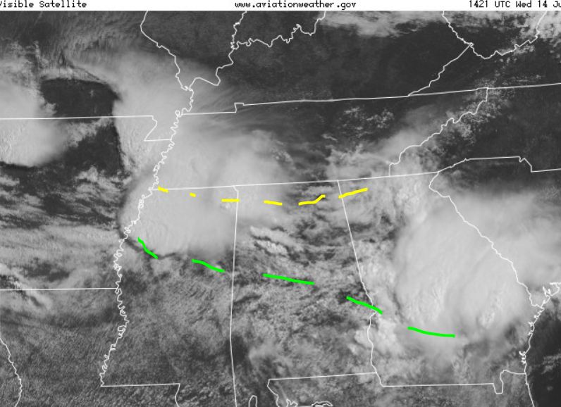
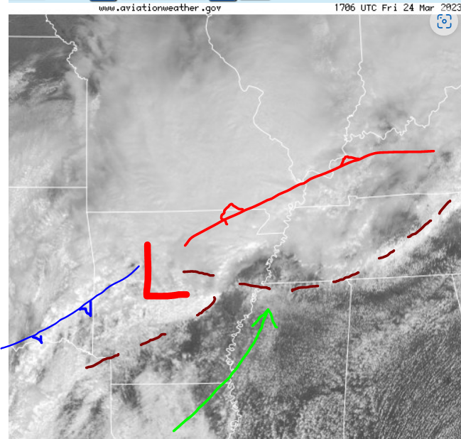
MD #1035 for central Alabama Storm Prediction Center Mesoscale Discussion 1035 (noaa.gov) kind of leaves the door open for a couple rotating storms. I would say the southern outflow boundary (green) has the most locally enhanced SRH. Northern OFB (yellow) has less direct access to the LLJ. Southern OFB also has better wind barb kinks. I used surface chart wind barbs and dewpoints along with visible satellite to place those outflow boundaries.
-
I think I follow Nadocast. It can get carried away, but it also gets things like Plateau magic. Can I say magic? Nobody got hurt. I did not know Ryan runs it though, haha! Just another tool either way. Thanks @John1122 for the reports Sunday. Glad you and yours are well. Nice pics @PowellVolz and @Holston_River_Rambler showing up the Mid-South with action in scenic East Tenn. I'm fairly confident the Cumberland Plateau over-achieves with tornadoes because it's elevated, which gets it greater low-level inflow. Wind typically increases with height. With the exception of a few areas of (scenic) bonus relief the Plateau is relatively flat compared to say the Mountains. I believe Alabama's Sand Mountain (more a plateau) gets the same effect. Areas of upslope likely play a role too. Any of the above increases local storm relative helicity SRH / low level shear LLS. Main reason chasers pick boundaries is due to greater SRH and LLS. Terrain does the same thing. High Plains chasers love terrain plays like the Palmer Divide and Raton Mesa, which also increase SRH/LLS. Palmer is also associated with the Denver Cyclone DCVZ. I'm not sure the Cumberland Plateau has anything like the DCVZ, but I believe the Plateau gets greater SRH/LLS. Combine boundary with terrain, and odds increase. If a boundary is over the Plateau, it may go!
-
Our two Hollies are slowly recovering, but it took until late May and early June. Our Japanese maple is fine. Some others dropped leaves, but had bounced back already in Feb. Chattanooga didn't get it as badly as up there though. Anyway the next week looks rainy around our region. Hopefully we can break the drought in parts of the region. Drought monitor shows dry and or moderate drought. If all goes well that's history after next week. Interesting pattern with strong 500 mb flow forecast next week. However, impulses (and LLJs) are timed night and morning, not really severe prime time. In summer one looks for MCSs not overnight severe. So, let the soaking rain begin.
- 295 replies
-
- 1
-
-
- severe weather
- frosts
- (and 5 more)
-
Yeah I'm really enjoying these dewpoints. Fetch from the ENE goes all the way to New England. I know it won't last. Next week will gradually return to reality. It'll be June! Guess the core of summer is humid either way, so hope for BN temps and AN rainfall. What I really want is some northwest flow thunderstorm action later in June. Only after that I will be ready for pop-up summer afternoon stuff. I'm not really counting on the NW flow part though. Week 3 is the wish-cast zone, lol!
- 295 replies
-
- 2
-
-
-
- severe weather
- frosts
- (and 5 more)
-
Yeah @Carvers Gap seems somebody in Riverton with my view of the world wrote that AFD, lol! Smoke has reached Tennessee, but nothing intense. Low dewpoints on the east wind is nice, but the high press up North is funneling in smoke. Sky is milky where it's blue. For a minute I was missing deep blue sky; however, the only path to that now is a pure tropical airmass. Eh, I'll take smoke (mild of course) over 70 Td.
- 295 replies
-
- 2
-
-
- severe weather
- frosts
- (and 5 more)
-
Outflow boundary and backed winds there gives those storms just enough to rotate. Most of the tornado warnings today are riding that outflow boundary to the ESE.
-
Part of me wants to be on the stretch of I-75 north of Knoxville, close to Kentucky, that's up on a high ridge. One can see forever. Pretty sure neat things could be photographed up there, even if just clouds and lightning. Otherwise most of the terrain up there is unfavorable. I would like the intersection of the East KY outflow with the synoptic front, but I have to pass. Though not common, severe wx can and does happen in the mountains.
-
Yes @Carvers Gap @PowellVolz the thunderstorms have a more summer feel than spring right now. Feels early, but we need the rain. Northwest flow is morphing into zonal with waves kicking out of the Plains. This week into the weekend looks warm. Next week temps should back down closer to normal. That NW flow may be the dry version. Wind should calm down when the pattern is less active.
- 295 replies
-
- 5
-
-
-
- severe weather
- frosts
- (and 5 more)
-

Fall/Winter Banter - Football, Basketball, Snowball?
nrgjeff replied to John1122's topic in Tennessee Valley
Weather patterns like to get more amplified coming out of winter into spring. Following the warm winter, the Arctic plays games on the spring jet stream. Autumn has not changed as much as spring, because the Arctic was always mild coming out of summer. Now I hand off to the Climate Change section of the forum. Totally separately, WSJ reports a freight recession, smaller cargo loads, and fewer big rigs. Hmmm. I don't see that here. Who else still observes trucks clogging the Interstates? My guess is WSJ has national stats. Our regional economy remains strong. Silver lining to all these trucks everywhere, lol! -
Fall/Winter Banter - Football, Basketball, Snowball?
nrgjeff replied to John1122's topic in Tennessee Valley
The extended forecast storm track Apr. 25-30 would be nice in winter. -
If you liked Monday and Tuesday, you'll love next week. Looks like a few days of cool nights/mornings and mild afternoons. More than a pair of days, but not quite several days. These warm days are nice too. Does not feel anything like summer, barely even late spring. Dewpoints are very low and the sun angle is not quite there yet. It's just over half way. The warm side of that glass half something, I concede that's also late August going into Labor Day sun angle. Explains some AC even though it's nice out. OK back to my Severe Weather thread safe space. Virtue signaling has been a little smug recently.
- 295 replies
-
- 3
-
-
- severe weather
- frosts
- (and 5 more)
-
Yeah, High Risk isn't something we see every day. In fact the Region sometimes skips a year. Only 2-3 nationwide each year. Arc of soon to be supercells is developing from Missouri to Arkansas as I type (Noon or just after Central Time). Morning showers left outflow boundaries OFBs. Atmo will destabilize with broken sun. Prefrontal trough(s) to intersect OFBs. SPC seems to key on southeast of the synoptic triple point TP Iowa/Illinois. Southern stream TP is forecast Mid-South. Some of it is mesoscale, but also southern forcing aloft. Not much else to add to SPC. Today is not a chase day. Thinking of those in the risk areas. Work calls too. This is likely my only post until the true weekend.
-
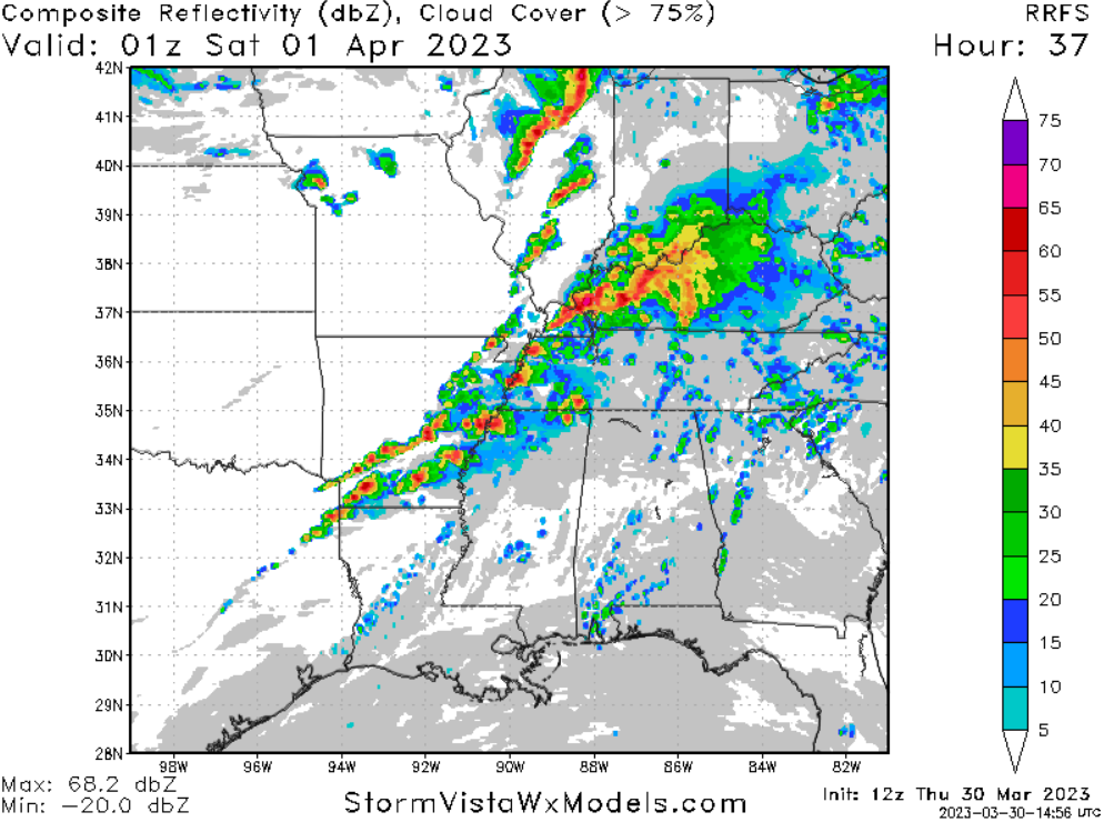
I see why SPC is 'concerned' about the Mid-South. However this RRFS is just one model. Others have a broken line, but not this brutal line of kidney beans. Line is on a prefrontal trough. HRRR is beefy (no surprise) but not as intense as the RRFS. ARWs (research WRFs) are split. Old is beefy with some sups, new ARW2 gets sloppy fast. Ditto FV3, which is interesting* because it does OK with storm mode. NAM is doing NAM things, over forced and probably not enough CAPE. *Interesting in that the sometimes bullish FV3 is a little less intense than some others this time. Still regardless of radar simulations, the environment will be robust CAPE and shear. At the low levels, surface moisture will surge north. Morning and midday showers should leave outflow boundaries, but cool air may not linger. Strong synoptic system should advect unstable air in as boundaries retreat. One or two pre-frontal troughs is forecast. Boundaries and their intersections will be concerns.

-
Either way the CAPE will probably be 'skinny' on the Nashville Skew-T overnight, without diurnal heat. Low level CAPE will depend on steady temps after the initial sunset drop. General wind shear aloft is forecast overnight into Middle Tenn. As usual overnight shear can endure when CAPE fades. Still early to forecast low level shear and boundaries though. Mid-South late Friday afternoon into early evening is a bigger concern. CAPE and shear will be juxtaposed. A prefrontal trough or convergence zone could be surface drivers. Such details are still TBD.
-
A true Gulf Coast warm front lifted through Mississippi last night. Appears it intersected a couple pre-trough convergence lines. Due to the deep moisture with a Gulf WF instability remains overnight. Separately In the satellite chart on my Friday post, appears a couple dark lines in central Mississippi make a T. That could have been another subtle boundary intersection, but at the time a little dry air just off the surface kept it in check during the day. The loss of life is tragic. Agree with Matthew that in the South significant tornado events are usually bad news. Back here in Tennessee the lifting outflow boundary (well north of the Gulf boundary) tended to focus straight line winds. However some QLCS tornadoes were reported in North Alabama. Got sideways rain on straight line wind at 3am in Chattanooga. 0656 65 4 ESE CHATTANOOGA HAMILTON TN CHATTANOOGA ASOS RECORDED A 65 MPH WIND GUST. (MRX)
-
Outflow boundary OFB re-lifting now through the Mid-South is going to be trouble. Initial line coming into Memphis might not have the moisture yet. Dry pocket aloft Mississippi means the best 850 mb moisture has to sneak up the Delta. It should be there late afternoon, along with the SRH on that outflow boundary. Hopefully for MEM, the OFB is elsewhere later. It is lifting north but could stall or sink with the early afternoon precip. OFB should also snake through Middle Tennessee later this evening. By then storms could be more QCLS than sups. Also have to watch the synoptic warm front if the air between the OFB and WF can warm up. Otherwise it's a big ol' Southern line overnight.
-
March 2023 Mid-Long Range Discussion thread
nrgjeff replied to Holston_River_Rambler's topic in Tennessee Valley
Fountain beat me to it. Not too upset to see the system vanish days 5-6. Note that WPC still has QPF those days. I'd be happy to see the system show up again, without a mega-cut knuckle ball. Carvers STL captures that idea, lol! Never take anything off the table in the Southeast. 12Z Euro update. Nah, I'll tell you what's gonna happen. Spoiled NC whiners will get one on the coast. Is that even worse than the STL cut?