

nrgjeff
-
Posts
3,903 -
Joined
-
Last visited
Content Type
Profiles
Blogs
Forums
American Weather
Media Demo
Store
Gallery
Everything posted by nrgjeff
-
Hoping for another great foliage year. RE the East ridge. Do you know what I really want to come of that? Trough Midwest, severe weather of course!
-
Euro is relying too much on classic El Nino. I'm more with the climate trend and CFS. Blowtorch. No hope.
-
Interesting, because lower elevations have been hotter than forecast. It's frustrated the hell out of me tbh!
-

Fall/Winter Banter - Football, Basketball, Snowball?
nrgjeff replied to John1122's topic in Tennessee Valley
KC Chiefs won't have home field if they even make the playoffs. Time to focus on college. Go Vols! -
Mood after looking at weather data Carvers is probably right unfortunately. Early 'canes will just act like warm fronts. Maybe we can get a break in mid-Sept.
- 295 replies
-
- 4
-

-
- severe weather
- frosts
- (and 5 more)
-
Unfortunately the model consensus is on board.
- 295 replies
-
- 1
-

-
- severe weather
- frosts
- (and 5 more)
-
Checked on the weekly forecasts. ECMWF CFS GEFS
- 295 replies
-
- 4
-

-
-
-
- severe weather
- frosts
- (and 5 more)
-
Good points about ENSO enhancing corresponding phases of the MJO. That's kind of how the pieces come together. Until the secondary pattern crashes the party. Like this 600 dm hell ridge! I find the least value in forecasting weeks 4-6. We've done statistical studies that show zero commercial value over climo, sometimes even negative value. I don't even look past week 3 on the weekly products. The 2nd month out to seasonal can add a little commercial value. Month 2 if one can get the MJO or other meaningful teleconnection it can help. ENSO is better at less granular multi-month time frames. Even such very general forecasts can add commercial value if the sign is right. Unfortunately that's maybe 1/3 to 1/2 of seasons. The other half we live with it. Nobody should make detailed plans based on a seasonal forecast anyway. Still that's actually greater commercial value than weeks 4-6 forecasting at zero.
-
Hillary and Harold both probably worked to amp up this ridge. TOP (Kan) and other balloons recorded record high 500 mb heights a few cycles ago. Then a damn stationary front caused pooling dewpoints. Only in 2023 do we get 70 dews below a 600 dm ridge. And yes I am string to wonder @Carvers Gap about another September with AN dragging out worse than pre-season football. Can we just get to Real Fall?
- 295 replies
-
- 4
-
-
- severe weather
- frosts
- (and 5 more)
-
Next week could be the hottest week of the summer in East Tenn. I believe the Mid-South already logged their hottest week. Ensembles are settling in on a clean ridge, not many if any t-storms. Ridge parks and simmers.
- 295 replies
-
- 2
-
-
- severe weather
- frosts
- (and 5 more)
-
The 1960s and 1970s featured a -PDO and -AMO. Water off the coast of both oceans were cooler than normal. It's a recipe for cold everywhere with jet stream stuck south. The PDO and AMO are offset by about a decade. +PDO -AMO in the 80s was great for full latitude East troughs. -PDO +AMO in parts of the 1950s is a mixed record, sometimes stormy sometimes drought. Both + is warm everywhere, none of the advantages of one, just the disadvantages of the other. Question is, can we ever get the oceans to sink heat again? Aaannnd, off to the Climate subforum. Maybe I'm just pissed off about the forecast heat next week. I'm still optimistic about some dumb luck with El Nino this winter.
-
Storms got real up that way. I think down here (southeast Tenn) the mid-levels never cooled off enough. Got some good lightning and stuff. But it came from skinny towers. Guess I can't say turkey towers with lightning and rain, but they had that scrawny look. Note I might have missed more robust Cu since it was dark, and I relied on lightning only.
-
Fortunately, both low level shear and deep layer shear were not enough to sustain a tornado. CC drop could have been a brief touchdown though. We're looking forward to the other kind of touchdowns - from the Vols! Now.. here in Chattanooga 10am, where the hell are my 60s dewpoints? This 70s stuff is FUBAR.
-
Humidity scale is expanded. Old: Humid, Ridiculous, Ludicrous. FUBAR is an additional category. 91/77 in KCHA. Welcome to the Persian Gulf, at least the Td part.
-
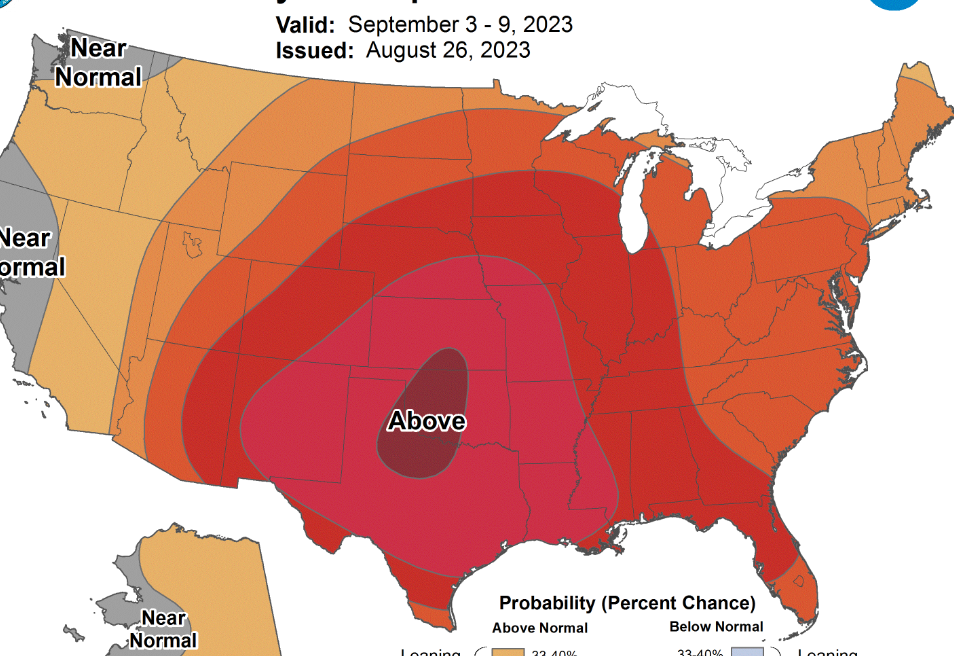
Carvers covers the different flavors of El Nino well, just above. John covers other hemispheric pattern drivers top of page. I prefer QBO trend to a steady value, trending down and ideally into negative. El Nino looks like it wants to stay basin wide. While I have concern about strength.. If the summer pattern can hold into fall and winter, it's of course favorable for temps Middle and East parts of our Region. Mid-South should get its turn too. We'll know more about this through Sept. and into early Oct. Note the polar source remains very warm. Canada and Alaska have MA temps this summer. In El Nino the Southeast relies on the southern stream anyway. If the current Atmo response continues into autumn, I'd be cautiously optimistic. If by wavelength or other debacle we torch, I'll just chalk it up to living in the South.
-
Mid-South portion of our Region had a summer. The rest of us enjoyed a mild summer. Indeed we may all get it next week. Looks like a pretty stout ridge building. Twitter is getting a little carried away though. Did they forget Normal temps are dropping now? Leaves look good right now. Even that heat won't be a problem before September. We need to avoid more of that crap though. I generally agree spring is more important than late summer. Exception is if that ridge parks for 3 weeks. Doubtful though. Ridges tend to be short-lived this summer before retreating to the Deep South, Texas and Southwest. Maybe we can get a hurricane under that ridge for something to track. Though I'm not rooting for that over such warm SSTs, late Aug. is when the season usually ramps up quickly.
- 295 replies
-
- 8
-
-

-
- severe weather
- frosts
- (and 5 more)
-
Sexy outflow boundary sits to my west, even with a kink. Too bad it's capped and directional shear is low. Only speed shear is there. For that 2% Upper Plateau.. gonna need that outflow boundary to lift north. Possible with a break in the action, but I'm an Under bet.
-
Feels like May lasted a day. Dewpoints today are atrocious! Also need to motivate myself to get out in the middle of the night for the Perseids which also requires a little drive out of the city. It'd be easier if the US was still in the World Cup, overnight games. Apathy may prevail because I'm tired.
-
Thank you @PowellVolz so the CC dropped. Was rotation evident on radar? If not, I could see them thinking CC was something else. If a CC drop is co-located with rotation, then it should be a tornado warning. Back to today, I think the best shot is on the afternoon Mid-South mesoscale discussion. Boundary has slipped south of Memphis which is good. For chasers that flat Delta terrain is just what the doctor ordered! Though the meteorology remains conditional.
-
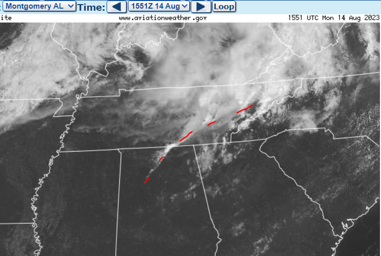
Catching up, what a week. Yes @Dsty2001 I believe that's a wall cloud on the previous page. While it looks scuddy, a likely collar cloud leading into it is the giveaway. Indeed, the whole feature is probably a wall cloud. Does anyone have saved radar data from the Knoxville tornado? Especially the few minutes leading up to the event. We had a power outage in Chattanooga at the time, so my focus was elsewhere. Looking at TODAY, a boundary sits across Tennessee from northwest to southeast. Boundary should focus any MCS and line segments. Perhaps closer to Arkansas the boundary can enhance SRH. Down by Chatanooga I think it's just good to promote straight line winds. Storm mode should be more conductive where SPC has the 10%. Though I doubt much will be visible if it's HP. Some of the CAMs have beefy blobs, which could contain hail. We are truly having April in August. Storm mode does favor MCS (summer) but the jet stream and hail are out of season.
-
Fall/Winter Banter - Football, Basketball, Snowball?
nrgjeff replied to John1122's topic in Tennessee Valley
Speaking of the Vols.. New Zealand upset Norway in the FIFA Women's World Cup opener. Home field probably helped with the 1-0 win. Guess who scored the goal. Former Lady Vol Hannah Wilkinson! So in a sense, football season has started. -
Dialed down the heat forecast late week by 4-5 degrees. Looks like scattered t-storms most days vs clean ridge. Risk is that MCSs timed night and morning still allow hot afternoons. However overall, heat forecast has backed off locally. Other parts of the US it's still Pain. Still the Tennessee Valley and Oho Valley have benefitted from a hot bias in models. In other words, the forecast gets less hot as the extended becomes short-term. Very end of July into early August remains a possibility for hotter than normal. However the bias has been for those forecasts to diminish inside 10 days.
- 295 replies
-
- 3
-
-
- severe weather
- frosts
- (and 5 more)
-
Dewpoints are atrocious right now. Review of the Spaceballs scale... 65-68 humid. 70-72 ridiculous. 74-76 ludicrous. Most of us have gone plaid.
-
Yeah I think we are going to escape with a reasonable summer. It ain't over until the August lady sings, but evidence points to more of the same. Global wind has dropped*, but it's already progged to rise again (milder signal). Now it does look like a hotter than normal period late next week and early the following week, so straddling the weekend of July 22. Anomalies in our region won't be too high, but it's the hottest time of year by climo. We all knew late June would not be the only hot burst. *Note the next couple weeks could be a bigger national heat story, just thankfully not in the Tennessee Valley or Ohio Valley. Desert Southwest may set record highs. Texas goes back into the cooker. Soon it'll be football season. Training camps open in the next couple weeks! Finland getting ski season going in October? Makes sense at that latitude. Big NATO ski party, haha!
- 295 replies
-
- 5
-
-
-
- severe weather
- frosts
- (and 5 more)
-
You didn't miss much. Beach >> non-rotating storms.