nrgjeff
-
Posts
3,954 -
Joined
-
Last visited
2 Followers

.thumb.jpg.049f4a7f726ada07e8cd30bd17e713cb.jpg)
About nrgjeff

Recent Profile Visitors
9,799 profile views


-
I'm skeptical of the tornado threat all the way to I-65 Sunday night. Feels like maybe sups in Arkansas grow upscale into a QLCS in West Tenn. Few tors possible out there. Perhaps just straight line in Middle Tenn. Hopefully East Tenn is just good sleeping without a sound machine to make the thunder. Refer to official forecasts though!
-
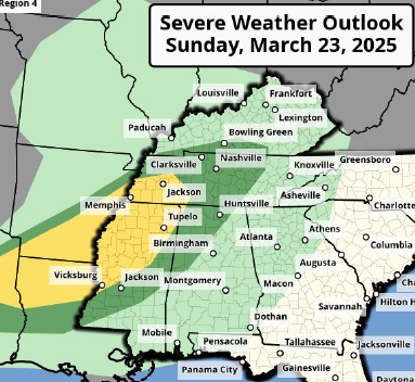
Well the Mid-South looks a lot more interesting this morning than it did just last evening. I'm writing Friday for Sunday. Parameters have not been a question now for days. Wind shear will be there with plenty of turning. Instability should happen. Models are starting to key in on this secondary WF that usually comes up from the Deep South. Saturday showers should drop a boundary. Sunday synoptic WF will be up in the MIdwest, but that's not my concern. They might have problems becoming unstable enough for classic cells. Arkansas is a different story. Discrete storm mode is implied and that rolls into the Mid-South by Sunday evening. Prefrontal trough or convergence zone should develop ahead of the synoptic CF. Intersection of that and the outflow boundary, plus several surrounding counties will become an area of interest. Too early to pinpoint it yet. Pattern recognition at both the synoptic and regional level points to an interesting Sunday in the Mid-South. Hopefully it'll be junk by Sunday night in East Tenn. Shelter at 3am sux.
-
Sunday inhiation could be as far northwest as the Ozarks of Missouri. We'll see. Maybe Saturday night will push boundaries southeast. However warm mid-levels may prevent much Sunday morning precip. A clean warm sector would get started well west of our Region. Current thinking is that Missouri and Arkansas Ozarks go late Sunday afternoon. Might take until evening to reach Kentucky and Tennessee. Parameters will be robust, but the greatest forcing could be north. We'll see if winds aloft stay strong and if any boundaries can sink in here. Also the notorious secondary warm front may lift north into the Mid-South. Synoptic WF looks north of the Ohio River. So many questions and it's just Day 4 - feels more like winter forecasting. My interest in chasing is starting to wane. Overnight? Long way off, and I don't feel like doing overnights yet this early in the season. Plus the weather will be gorgeous in East Tennessee this weekend. Finally the Elite Eight looks, actually elite this year.
-
Things like that happen in central Oklahoma too. Why do people keep moving back to Moore? Excellent schools sells houses! Anyway the 6-10 day and 11-15 day 500 mb charts still look similar. Details are TBD. I just want to figure out Sunday first, ha!
-

Fall/Winter Banter - Football, Basketball, Snowball?
nrgjeff replied to John1122's topic in Tennessee Valley
We might need a Spring Banter thread. Anyway the Day 3 looks like a Dinosaur Attack!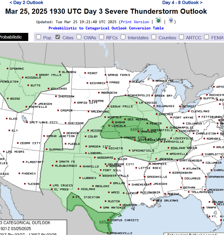
-
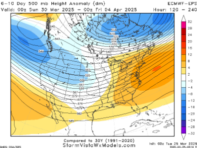
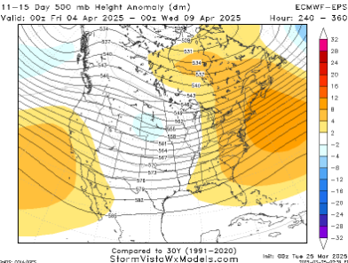
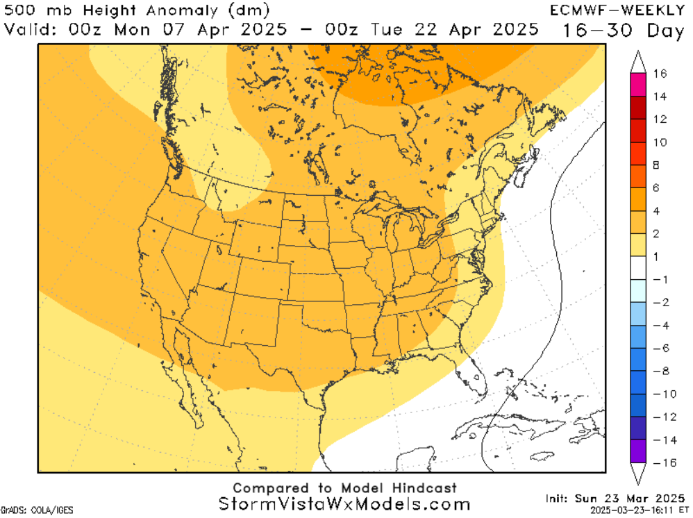
Follow up to my post above. April looks above normal, but not 2011 crazy. Still holds. Now we might get a good chunk of that activity the first 7-10 days of April. Then the quieter ridge pattern is forecast. Here is the 6-10 day and 11-15 day 500 mb charts, which basically goes until April 8. Keep in mind that could go Midwest instead of Mid-South. We'll see.
-
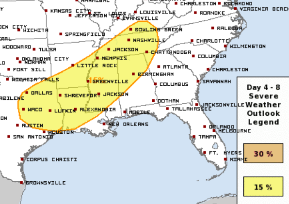
Glad we have a weekend outlook. Perhaps I can stay out of that toxic off-topic Politics thread and talk Weather over here. The case for more severe, ha! ECMWF has some odd low coming out of Texas trying to gum up the works for the weekend. However it should shear out a bit on Saturday. in May I'd worry about it wrecking the set-up. In March I believe the mid-latitude jet stream will assert its control. Go GFS! So the Plains gets the Day Before the Day. Hopefully just right showers linger into the South. Need outflow boundaries - not a nutty MCC washout. Midwest looks conditional, but the 15% is justified in case of a huge warm sector. Mid-South probably has the best odds, but I agree 15% for all of the Tennessee Valley on Sunday.
-
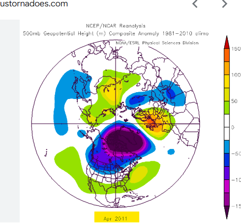
Mercifully the 5-day average forecast 500 mb heights into April doesn't look much like 2011. That year a persistent trough sat in the Rockies. If you are storm anxious, try not to worry about 2011. April 2025 I believe the Mid-South will be more active than Average, but that's still far short of historic 2011.
-
Excellent storm mode is WASTED on pathetic instability. That's my post. Glad I didn't chase. Back to betting and basketball.
-
Sunday refuses to show a chase target, as of Friday evening. SPC is worried about the cold front, but I think we'll have a prefrontal trough. Should have outflow from early day showers. Problem is it may all be too cool. It's March not May. I believe there could be enough turning from 850-500 mph iff boundaries would intersect properly in an unstable airmass. Otherwise it'll look like North Alabama on Saturday. What about Mississippi? Needs quality boundaries. Juuust enough turning with height is conditional on locally higher SRH. SPC Day 3 update mentions north Mississippi but they don't sound confident. Looks about as low energy as Kansas or Memphis basketball. Cynical basketball metaphors are a risk for a few more days.
-
Sugar takes care of their snow. I figure this is the last weekend though. Meanwhile the forever cold that was forecast is down to 5 days next week. Perhaps we can warm up going into April.
-
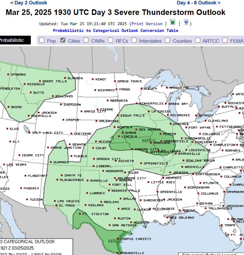
SPC extended the Slight south at 20Z and posted the watch. Looks like storms crapped out. Odd, because I wasn't chasing. That was such a Jeff is chasing move. Sunday has become more interesting with a bigger warm sector and farther north boundaries. Now the low level winds are veered off. However, the upper level winds are almost from due west, not southwest. That's just enough turning, esp near surface boundaries with enhanced SRH. Way too early to place those, but pre-dawn rain could set the table. SPC outlook I infer is the southern and northern envelope of where said boundaries could land. Issued Thursday valid for Sunday
-
Warm front WF is pretty obvious in northern Illinois. Less discernable, but subtle, an outflow boundary OFB has sagged south from there. Intersection of that OFB with dry-line like feature (sfc trough) out of Missouri should trigger discrete supercells in central Illionois this afternoon. WF could also recharge / destabilize again late. Plenty of cross boundary flow at the mid-levels favors discrete mode. Moisture is a little bit last minute, but cool mid-levels will promote enough instability.
-
Sunday will also depend on who's still in the NCAA Tournament, lol! Has the potential to work because 500 mb is almost straight west. Don't need 850 mb textbook backed. Again it'd be a gem late season. We'll see in March. Need a juicy boundary.
-
Wednesday looks meh. Later in the season I'd hope for a mesoscale accident, but NCAA play-in games look like a better option. Sunday Deep South is looking more poorly oriented. Still early in the season, but I have concerns SSW could kill the first half of April. Later in the season a -AO can help get the jet stream going. This early, it's crap.