nrgjeff
-
Posts
3,990 -
Joined
-
Last visited
2 Followers

.thumb.jpg.049f4a7f726ada07e8cd30bd17e713cb.jpg)
About nrgjeff

Recent Profile Visitors
9,886 profile views


-
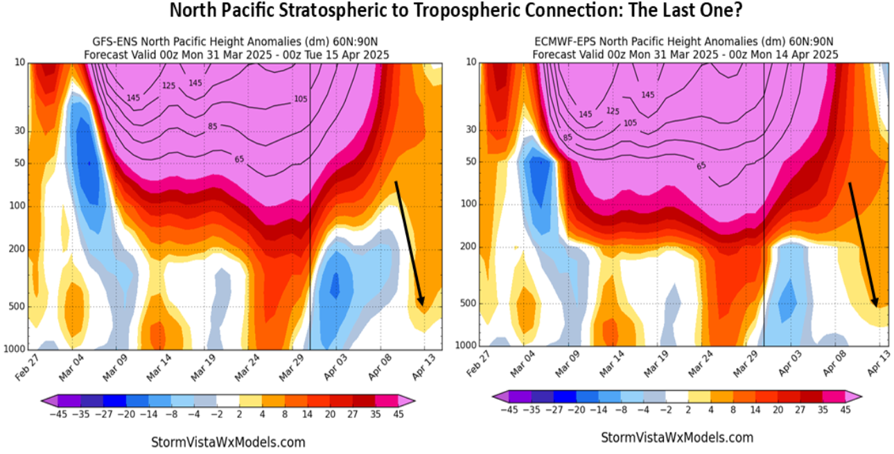
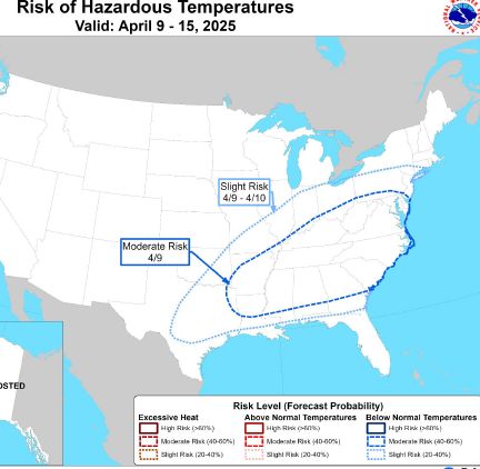
Twitter is now melting down because the hype casts will bust. X marks the spot for poor science, lol! It never looked like a classic sequence, just seasonable flow returning after the Gulf Coast scouring this week. Just seasonable certainly means some sloppy days. Easter Sunday looks like a glancing blow Mid-South to Midwest. Then it looks like rain gets in here next week, but I'm not sure how much severe. Big concern (Plains chasers) is we go from sloppy to capped, with few classic days. For the South that's sloppy to nothing. Much of that (Plains) depends on QPF this weekend into next week to set up (or not) the beginning of May. Drought Monitor has improved markedly but needs more work.
-
Thursday may be the last cool morning for a while. But yeah, I still wouldn't plant tomatoes up on the Plateau. Weekend may have a late spring feel. Getting the weekend front south of I-40 will be a chore as the ol' SER perks up. Looks like next week the front finally drops behind the Sunday system. That looks like Mid-South straight to Midwest. Mercifully East Tennessee looks quiet Easter 2025. We have not forgotten Easter 2020. Then toward May the jet stream gets gummed up. Models are still moving things but slowly. Most ensemble members have normal precip. A few block out much of the Southeast esp GEFS. The EPS has more rain.
-

Historic Tennessee Valley Severe Weather Events
nrgjeff replied to Holston_River_Rambler's topic in Tennessee Valley
I love the unpolished look to the radar and the graphics. Also the teletype back then. Keep it raw, like wild weather should be! -
Yes the center of the action should gradually shift north and west into the Great Plains. Southern season still has a few more weeks though. See if this weekend Plains system can hold together into the South next week. Then the far extended end of April forecast is very up in the air. Looks like decent flow is forecast across the Lower 48. Whether it's southwest flow (Plains) or choppy remains to be seen. Choppy version would be less intense but might allow rain into our region.
-
Steep mid-level lapse rates and cool temps at 700 mb and above on Thursday may promote golf balls. Who moved the Masters north? Also the low levels of forecast soundings are inverted V which allows for some gusty wind. Valid Thursday April 10
-
This April 20 severe wx system keeps getting pushed back. When did severe become like snow? This after Chatty got two nice snows, lol! Quiet weather pattern may be more favorable for star gazing and getting high on April 20. We'll see. End of April temps may get back to above normal. Seems like we get this mid-April cool snap every year. Then we can start Real Spring.
-
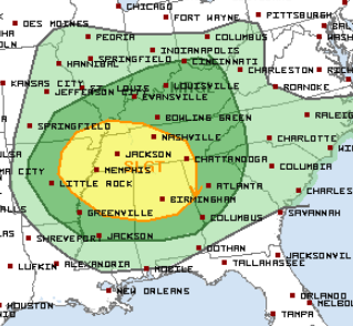
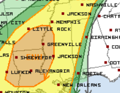
Might be recharging for this afternoon. Wind shear is definitely there with the consta-LLJ. See if destabilization can happen both sides of the boundary. However I'm a lot more interested in Saturday when I'm free. Final wave ejecting is usually boom or bust. Wind speed shear will be plentiful. Turning with height is just barely enough; it will require backing at the surface. Also need a prefrontal trough ahead of that CF. Both depend on an Arkansas surface low for Mississippi chasing. Thursday MD Day 3 Saturday seems mostly synoptic front based. Need ENH across Mississippi but SPC might not be feeling the pre-frontal trough.
-
Southeast Tennessee could have record high temps Friday. Then after the front..
-
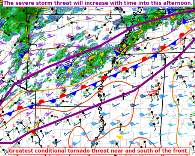
Tonight is a rare instance where the lead supercells choked off the line behind, rather than coexisting with the line or being absorbed. Probably just right (just wrong) flow angle crossing boundaries. Line doesn't catch up. Sups go nuts! Re Arkansas I saw some streams with radar/locations in corner put together like Zoom. Definitely different cells. Multiple damaging tornadoes were in progress. Can't link preview. I won't try to rate strength, but they were all big specimens.
-
Even bigger dislike if the sand front sags south of one's location and it rains forever. But yeah record highs are possible south of it. Joy! Then frost next week! I thought the Plains weather was wild until I moved to Tennessee. The Valley is like, hold my beer! In between I'm looking for a proper trough ejection on Saturday. Probably won't happen. More QLCS trash. At least we have the SEC dominant Final Four!
-
High Risk of a QLCS! I'll believe these discrete cells ahead when I see them. RRFS is on an island all alone. Then the HRRR today wants to go in Mid-Tenn. Low level shear is wild but the mid-levels are too warm. What's the MLB and NBA TV schedule this evening? Blue Bloods reruns on Ion channel 3.3 in KCHA. I hope my cynicism assures some who are storm anxious. That said, follow official sources if it gets hairy tonight!
-
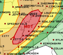
Well then. Looks like SPC is going with that gnarly RRFS which is phat supercells all over the Mid-South. We'll see. Training supercells part is pretty likely regardless of how discrete. Should be an absolute mess. Valid Wednesday (and night) April 2
-
After the severe weather and flooding this week, weather pattern may turn cool and quiet for much of the rest of April. First of all Wednesday looks a lot like Sunday with Mid-South severe rolling into Tenn. SPC chart even looks like a copy/paste. Upper jet is stronger. LLJ will depend on wave timing. Ditto Thursday. One real problem with the LLJ, while fluctuating, constantly runs up and over a quasi-stationary boundary. WPC forecast QPF unfortunately could be reasonable. And now what might help quiet things down after the weekend.

-
Yeah I'd rather bark at my TV both Tennessee and Auburn, than bark at cells going linear too fast, or getting blocked at the River. Charles Barkley had very deep thoughts about the first half and taking care of the ball. In the game of basketball, the most important thing is the basketball! Classic Chuck. Anyway, still not MDT. Just a huge wind 45% no hatch, lol. TOR is still 10% hatched. I agree that hodographs will enlarge this evening. In some cases lines can actually break up and go super. I'm not feeling it today, but QLCS tornadoes are quite possible overnight.
-
That crap happened in Chattanooga Wednesday and Thursday. Local fire with a slight temp inversion at just the wrong level and backing wind with height. All contributed to Metro wide yuck! Looking ahead, Wednesday could be quite the severe weather day. Unlike Sunday's struggling LLJ set-up, kinematics looks robust at all levels on Wednesday. Instability should be there too. Still much depends on surface features.