

grhqofb5
-
Posts
152 -
Joined
-
Last visited
Content Type
Profiles
Blogs
Forums
American Weather
Media Demo
Store
Gallery
Everything posted by grhqofb5
-
I've mostly lurked here over the past several years, just posting my observations during snow events. I have a couple of general questions about models, don't know if this is the right thread but don't want to post on a subforum that's dead with no chance of a response. (1) When models spit out the contoured snow maps, do the figures within those maps represent a mean projected accumulation (i.e. if its 6 inches, that means a deviation of +/- 2" depending on confidence level), or do those totals represent the maximum projected accumulation (i.e. not more than 6", within confidence level of 95%). I know these maps are always a snapshot in time, and some maps are specific about what they're showing, such as the 10% chance/confidence maps. But if not, are the figures just the mean? (2) I often hearing that ______ model has a north bias, a south bias, generally projects higher qpf totals, etc. If this is in fact true, meaning the bias is statistically significant, why aren't those models corrected to account for the bias? After all, aren't all of these models based on data or other markers from past storms, compared with incoming data from the current storm? And the purpose of any statistical model is to become progressively more accurate over time? Or are the people claiming real bias just weenies? (3) Everyone seems to have slightly different opinions, but as far as model supremacy is concerned, how do each rank at various stages of a storm (168 hours, 98 hours, 48 hours, 24 hours, 12 hours). Based on what I've observed, there seem to be three models that lead the pack, tell me if I'm right: EURO-- Seems to be the consensus best model at all stages GFS-- Seems to be about the same as the NAM, but NAM-- Seems to given more attention at about the 24 hour stage Then.... ICON, GEFS, UKIE, HRRR, GDEPS, GEM, CMA, etc.-- all works in progress. Any input would be appreciated.. Thanks!!
-
After an ~10 hour period of (mostly) steady, but never particularly heavy, snow beginning about 4pm yesterday, the grand total in Odenton, MD was 4.75 inches. Not bad, considering we appeared to be on the edge of a dry slot for a few of those hours.
-
Southern MD / Lower Eastern Shore weather discussion
grhqofb5 replied to PrinceFrederickWx's topic in Mid Atlantic
Damn, it was flurrying here in Odenton, now completely stopped. 35. -
Southern MD / Lower Eastern Shore weather discussion
grhqofb5 replied to PrinceFrederickWx's topic in Mid Atlantic
First flurries in Crofton/Odenton. 34. -
35 and not a single flake in Crofton MD.
-
When is it not a JV model?
-
Honestly, until 48 hours out isn’t the EURO the best model by a good margin, then the GFS? And then once we get to 24-48 hours, the NAM and EURO are pretty much the best until onset? Then look at whether the big blue thing on the radar is over your house and how fast/what direction it’s moving. And if the ICON, UKIE, GEFS, MEX, GPS, GEPS, PUERTORICO, STD, etc. end up being right 3 or 4 days out it really more luck than skill. Like it was right, but only because the sun shines on a dogs ass once in a while?
-
Awwwww yeaaaahh!!!
-
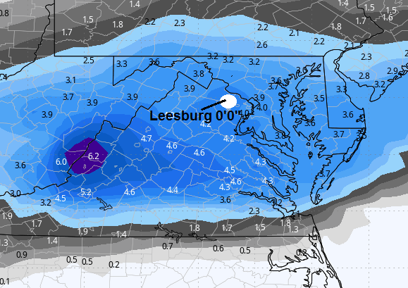
Here it is again for anyone who missed it. Hope we don't have anyone freak out in Loudoun County/Leesburg area.
-
You reading the same models as everyone else?
-
I didn’t know that. Who’s your favorite team? I like the Baltimore franchise. Also NY Mets.

-
Whoa! Is that what you guys call a Nor’Easter?
-
Thanks
-
Sorry, I’m a lurker/reader so dumb question. What 2 day time period does this relate to? It goes out 246 hours (10 days). Or is that the total mean amount for the next 10 days?
-
1/19 - The Roulette Wheel 29 Black Storm - OBS
grhqofb5 replied to DDweatherman's topic in Mid Atlantic
Nothing in Odenton. 37 degrees -
Whoa, University of Virginia is going to get 90"-100" inches of snow. That's like 4 feet!!! No streaking the "The Lawn" on Sunday night!
-
Late Feb/March Medium/Long Range Discussion
grhqofb5 replied to WinterWxLuvr's topic in Mid Atlantic
Like a record. Except the 300 ft ice wall in Antarctica that no one ever flys over. Because there’s continents on the other side. -
Ended up with about 5.25" in Odenton, MD. Heavy bonus bump came through last night to add another .5".
-
That’s good for La Plata!
-
There’s a 30% chance that the snow rain or ice will accumulate to somewhere between 0.1 and 3.0 inches, but only a 50% chance of that.
-
January 28-29 2022 Miller abcdefu Storm Obs/Discussion
grhqofb5 replied to mappy's topic in Mid Atlantic
Coming down hard in Annapolis, but not sticking to the roadways. 32 degrees. -
Man, I feel like I just read a script from a cross over episode of Gray’s Anatomy/Dallas/Dynasty/The love boat. Who’s going to shoot McDreamy? JR? Will Cliff Barnes take the First mate’s offer from Captain Stubing?
-
Or the 1994 version of Microsoft paint to redraw the lines.
-
Late January and February Medium/Long Range Discussion
grhqofb5 replied to WinterWxLuvr's topic in Mid Atlantic
Does Mexico have a forecasting model like the MFS or something? -
They measured snow in perches back then, not feet. Must be a forgery.


