Terpeast
-
Posts
5,326 -
Joined
-
Last visited
Content Type
Profiles
Blogs
Forums
American Weather
Media Demo
Store
Gallery
Everything posted by Terpeast
-
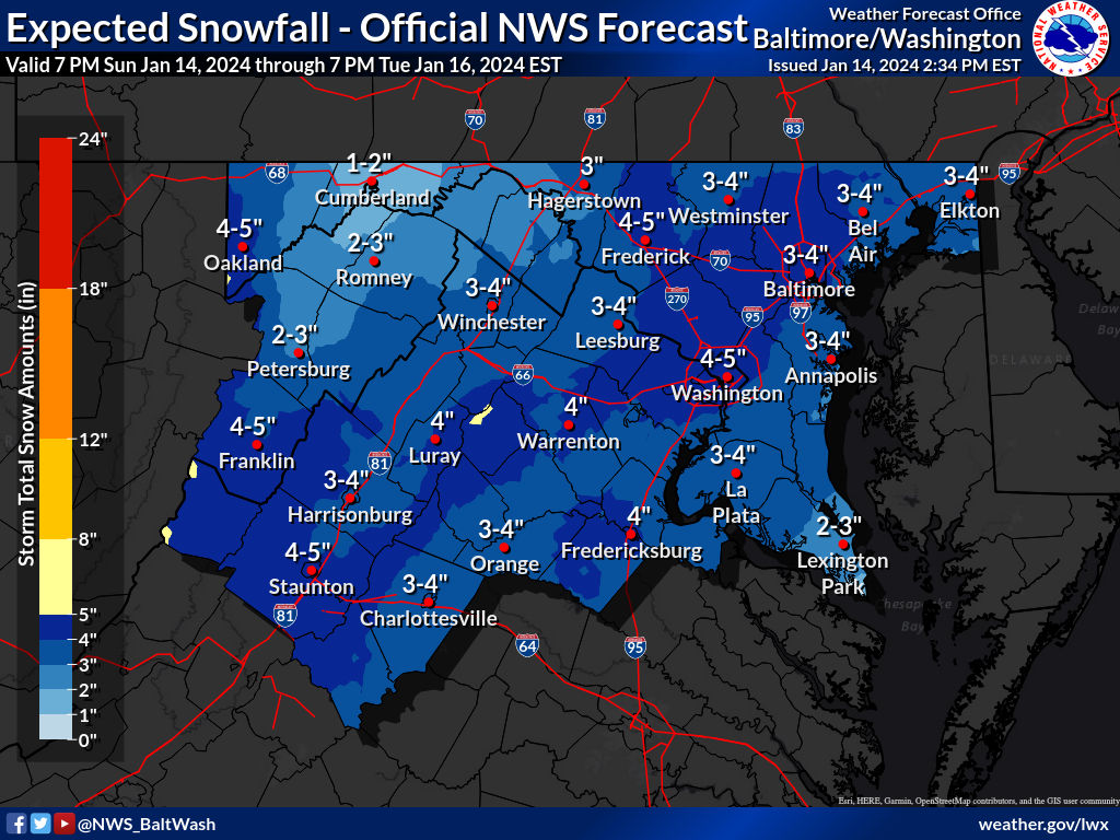
Jan 15-16 Storm Threat Thread: The Return of Hope??
Terpeast replied to stormtracker's topic in Mid Atlantic
Just maybe I won’t get fringed. And good thing is there isn’t enough time left for this NW trend to continue until this storm actually starts -
Jan 15-16 Storm Threat Thread: The Return of Hope??
Terpeast replied to stormtracker's topic in Mid Atlantic
What did the previous run look like? -
Jan 15-16 Storm Threat Thread: The Return of Hope??
Terpeast replied to stormtracker's topic in Mid Atlantic
Interesting how the wrf and hrrr shifted north -
Jan 15-16 Storm Threat Thread: The Return of Hope??
Terpeast replied to stormtracker's topic in Mid Atlantic
Nice runs so far. I think the 12k is overdone, 3k more realistic. But growing more confident for an area wide 2-4"er with someone getting 5"+ -
Jan 15-16 Storm Threat Thread: The Return of Hope??
Terpeast replied to stormtracker's topic in Mid Atlantic
Judging from that loop a few posts above, the euro is the furthest south of any model with that frozen precip field. The gfs does amp up amounts everywhere including down south, though -
Jan 15-16 Storm Threat Thread: The Return of Hope??
Terpeast replied to stormtracker's topic in Mid Atlantic
Not looking at the models till I get home, but I’m not looking for another trend. Just hold the line is all I ask -
Jan 15-16 Storm Threat Thread: The Return of Hope??
Terpeast replied to stormtracker's topic in Mid Atlantic
I don’t know what they‘re seeing to go that bullish. I keep seeing 1-3/2-4 -
Jan 15-16 Storm Threat Thread: The Return of Hope??
Terpeast replied to stormtracker's topic in Mid Atlantic
-
Jan Medium/Long Range Disco 2: Total Obliteration is Coming
Terpeast replied to Jebman's topic in Mid Atlantic
Was that the cold smoke quick hitter where the roads caved immediately? I enjoyed that one. Got 5”. Don’t remember expecting that much more, but it was close. Philly was expecting up to 18” -
Jan 15-16 Storm Threat Thread: The Return of Hope??
Terpeast replied to stormtracker's topic in Mid Atlantic
As I mentioned, a 2-4”er area wide without thermal issues even SE of 95 would be a great win and a nice compromise. Amping it further would be too greedy and get some of us in trouble -
Jan 15-16 Storm Threat Thread: The Return of Hope??
Terpeast replied to stormtracker's topic in Mid Atlantic
Wow, bullish. I was thinking 1-2” locally 3” -
Jan 15-16 Storm Threat Thread: The Return of Hope??
Terpeast replied to stormtracker's topic in Mid Atlantic
Yeah, I think those areas will be the winners, at least in agreement from the two groups of modeling. Personally, I’m not sure what to root for. The more amped NW group where I get more, but with potential ptype issues along and SE of 95… or the colder solutions with a central VA jack. Leaning towards the latter because I love cold smoke snows even if I get less. A compromise between the two would be perfect. -
Jan 15-16 Storm Threat Thread: The Return of Hope??
Terpeast replied to stormtracker's topic in Mid Atlantic
Some models say tomorrow midday, others delay it until tomorrow evening. Hard to say, depends on where that narrow band aims and when the column gets saturated enough -
Jan 15-16 Storm Threat Thread: The Return of Hope??
Terpeast replied to stormtracker's topic in Mid Atlantic
Looks like two groups of models, one has more snow NW of the fall line, the other has more SE. Gonna be interesting, and I hope everyone wins. -
Snow shower stopped here in Vienna
-
I’m at my mom’s house in Vienna. Light snow and windy.
-
Flurries in vienna/fairfax
-
Better than a dusting eh? Looks like I missed this. Not sure its going to quite make it to i-66
-
43 in vienna, dark clouds moving in from the NW. looks like summer tstorms I’m sure my house in ashburn has a dusting by now
-
Went to Vienna today. Might snow in Ashburn and not here. Lol
-
Jan 15-16 Storm Threat Thread: The Return of Hope??
Terpeast replied to stormtracker's topic in Mid Atlantic
At least the HRRR doesn’t show that 925 warm layer. For now. Either the Nam is onto something or it’s too warm -
Jan 15-16 Storm Threat Thread: The Return of Hope??
Terpeast replied to stormtracker's topic in Mid Atlantic
Well, that’s a new and surprising development with this system. Maybe I should not be so surprised -
Hrrr doesn’t get the squall line far enough south for the dc metro, but radar looks better. Can see the mountains eating it up south of 50
-
Jan Medium/Long Range Disco 2: Total Obliteration is Coming
Terpeast replied to Jebman's topic in Mid Atlantic
I think someone pointed out (maybe it was you?) that EPS has been doing much better in the long range than gefs this winter. -
24 low