Terpeast
-
Posts
5,326 -
Joined
-
Last visited
Content Type
Profiles
Blogs
Forums
American Weather
Media Demo
Store
Gallery
Everything posted by Terpeast
-
Jan/Early Feb Medium/Long Range Discussion Part 3
Terpeast replied to WinterWxLuvr's topic in Mid Atlantic
Ah, I was looking past that one! -
Jan/Early Feb Medium/Long Range Discussion Part 3
Terpeast replied to WinterWxLuvr's topic in Mid Atlantic
Gfs and canadian ensembles look the same. There’s not much to add to what’s already been said -
Jan/Early Feb Medium/Long Range Discussion Part 3
Terpeast replied to WinterWxLuvr's topic in Mid Atlantic
Folks. This is it. This is our best shot at a KU in 8 years. -
Jan/Early Feb Medium/Long Range Discussion Part 3
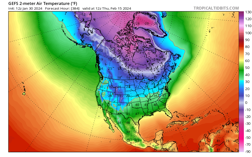
Terpeast replied to WinterWxLuvr's topic in Mid Atlantic
Cold air is on the way. Feb 1 (top) vs Feb 15 (bottom)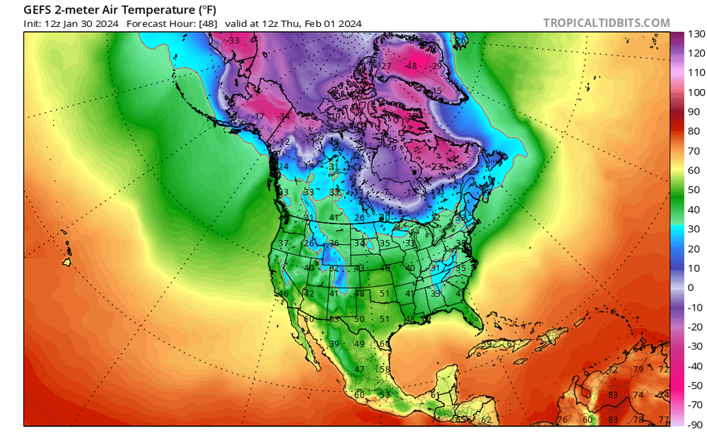

-
Jan/Early Feb Medium/Long Range Discussion Part 3
Terpeast replied to WinterWxLuvr's topic in Mid Atlantic
12z gefs shifted south for feb 5, geps shifted north. -
Jan/Early Feb Medium/Long Range Discussion Part 3
Terpeast replied to WinterWxLuvr's topic in Mid Atlantic
Remains a long shot, but still a non-zero chance. Not a great idea to get too invested, but worth keeping an eye on for any north shifts, especially by the gfs. -
Jan/Early Feb Medium/Long Range Discussion Part 3
Terpeast replied to WinterWxLuvr's topic in Mid Atlantic
looks plenty of cold air from rockies to EC if this verifies
-
Jan/Early Feb Medium/Long Range Discussion Part 3
Terpeast replied to WinterWxLuvr's topic in Mid Atlantic
Good sign that it’s staying around feb 14 or even moving a little forward in time -
Jan/Early Feb Medium/Long Range Discussion Part 3
Terpeast replied to WinterWxLuvr's topic in Mid Atlantic
Now that is a much better -NAO look -
Jan/Early Feb Medium/Long Range Discussion Part 3
Terpeast replied to WinterWxLuvr's topic in Mid Atlantic
President's Day window. Probably our last shot at the Big One as those have historically happened during this time frame. After the 20th, we'll be swimming upstream. Can still score then, just the max upside gets a bit smaller. -
Jan/Early Feb Medium/Long Range Discussion Part 3
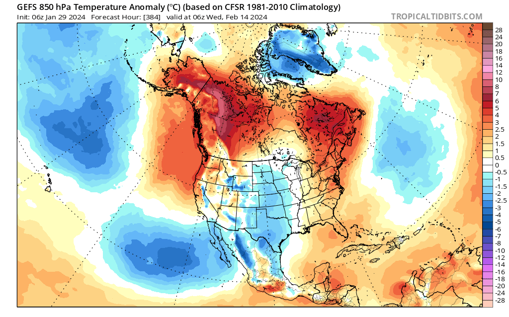
Terpeast replied to WinterWxLuvr's topic in Mid Atlantic
GEFS quickly turns cold starting on Feb 14. This is our new target. It may have shifted a couple days later from a week ago, but we're at the point that we cannot afford another delay, however minor it is.
-
Jan/Early Feb Medium/Long Range Discussion Part 3
Terpeast replied to WinterWxLuvr's topic in Mid Atlantic
Yeah, I still think we have a shot at beating climo and all it takes is one storm. NYC & north are SOL at this point, though. -
Jan/Early Feb Medium/Long Range Discussion Part 3
Terpeast replied to WinterWxLuvr's topic in Mid Atlantic
Tbf I don't think most of us are panicking outright. We're just starting to see what's really under the hood (using Bob Chill's words) behind the smoothed H5 means. A week ago, or even a few days ago, it was looking like the fun would begin around Feb 10. Now we're looking at Feb 14-15, and the window of opportunity is starting to get narrower. The clock is starting to run out on us, is what we cannot deny. Sure, we could go on a 2-week heater between Feb 20 and March 5 and beat climo by a large margin - that can still happen, and I WANT it to happen. But again, I wouldn't be surprised if that window gets narrower and narrower with time and we score only one moderate event until the next wave of warmth, by which time it's over or nearly over. -
Jan/Early Feb Medium/Long Range Discussion Part 3
Terpeast replied to WinterWxLuvr's topic in Mid Atlantic
Same page. It ain't over till it's over, but the fat lady is starting to warm up her vocal chords... is where my head's at now. I'm glad I milked the wintry week by taking pics, videos, going sledding with the little one (despite being sick at the time). I have a bunch of reels I could re-watch all year. -
January 31st Clipper. Will we get clipped or chumped?
Terpeast replied to clskinsfan's topic in Mid Atlantic
It's alright man, there wasn't much to ruin to begin with... -
Jan/Early Feb Medium/Long Range Discussion Part 3
Terpeast replied to WinterWxLuvr's topic in Mid Atlantic
Upside is what the CMC showed yesterday. But I think that path is closing. -
I hope you cherished that week. I did to the fullest, and if this winter ended today, I’d come away with that magical week satisfied. Not happy with my snowfall forecast and falling short of KU potential, but I’d be content with the best wintry week we’ve had in years.
-
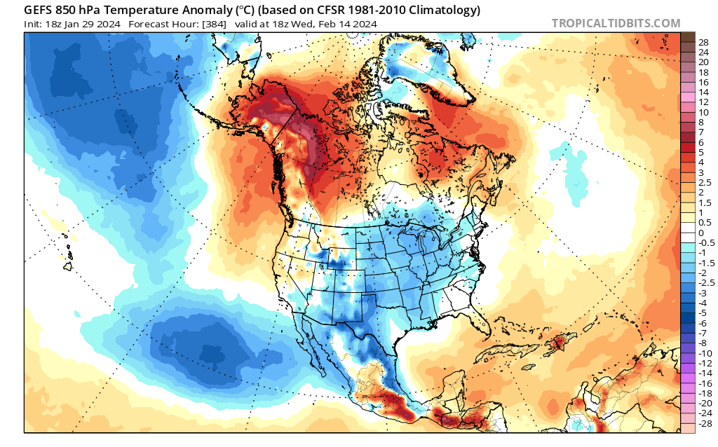
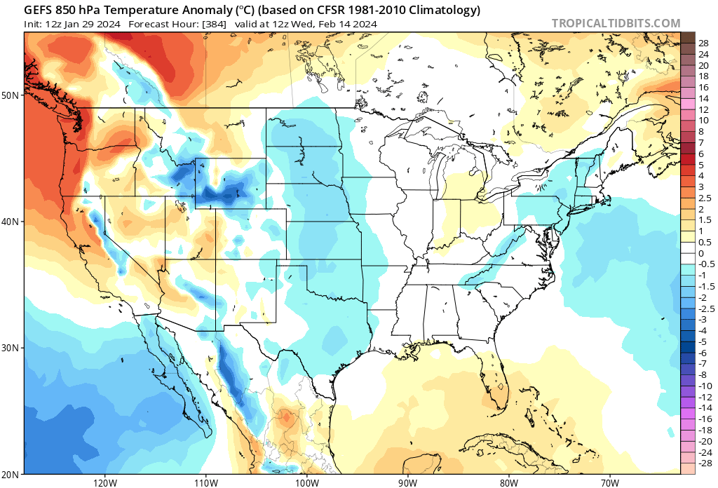
Jan/Early Feb Medium/Long Range Discussion Part 3
Terpeast replied to WinterWxLuvr's topic in Mid Atlantic
Not quite cold enough by this point, but getting there. Maybe a day or so later it’ll be NN slightly BN
-
Jan/Early Feb Medium/Long Range Discussion Part 3
Terpeast replied to WinterWxLuvr's topic in Mid Atlantic
Honestly I’d have preferred it to shift west so they could phase and bring down enough cold air for it to snow. -
Jan/Early Feb Medium/Long Range Discussion Part 3
Terpeast replied to WinterWxLuvr's topic in Mid Atlantic
And I don’t see any potential for wintry weather until VDay and beyond. My target was Feb 10-12 a week or so ago, and this is the first sign of a can kick, even if its by just a few days. Clock is ticking. Think I was right to revise my snowfall forecast. Another minor/moderate event might get us to the low end of my forecast. Otherwise it will be a bust. Hope I’m wrong, but things seem to be trending that way. -
Jan/Early Feb Medium/Long Range Discussion Part 3
Terpeast replied to WinterWxLuvr's topic in Mid Atlantic
If the temp issues don’t get resolved soon, this may just be the perfect track rainstorm that goes into PSU’s logbook (and I’m one of those who don’t think Jan 7 really qualifies) Still time. -
Jan/Early Feb Medium/Long Range Discussion Part 3
Terpeast replied to WinterWxLuvr's topic in Mid Atlantic
Eh, just loop back a few runs and they’re all vastly different. Models have zero clue how to handle this block right now -
Jan/Early Feb Medium/Long Range Discussion Part 3
Terpeast replied to WinterWxLuvr's topic in Mid Atlantic
Yep just saw that. This is not done changing yet. -
Jan/Early Feb Medium/Long Range Discussion Part 3
Terpeast replied to WinterWxLuvr's topic in Mid Atlantic
Something to keep in mind about model performance thus far this winter when tracking patterns/threats in Feb: https://www.emc.ncep.noaa.gov/users/verification/headlines/acc_31days/ GFS not doing well this year. Euro the best, with Ukie and Canadian very close behind -
January 31st Clipper. Will we get clipped or chumped?
Terpeast replied to clskinsfan's topic in Mid Atlantic
We’ll see with 0z nam 3k, but I think this one is DOA