Terpeast
-
Posts
5,326 -
Joined
-
Last visited
Content Type
Profiles
Blogs
Forums
American Weather
Media Demo
Store
Gallery
Everything posted by Terpeast
-
Op gfs forms another -EPO block at 300+ hours, but ensembles don’t have that yet. Something to keep an eye on whether we see another -EPO show up along with -NAO they keep showing
- 2,509 replies
-
- 1
-

-
- weenie fest or weenie roast?
- weenies got roasted
- (and 2 more)
-
I hope you all jebwalked that week of winter and filled up your phone with pics and videos to savor for the next year. Maybe the next two years.
-
Models/ensembles have trended warmer towards the end of Feb, but it wouldn’t surprise me if they trended back colder once the pattern change takes hold this week and the convection fires back up in the IO.
- 2,509 replies
-
- 3
-
-
- weenie fest or weenie roast?
- weenies got roasted
- (and 2 more)
-
6z gfs at 150 + 0z euro at 234 0z cmc also shows support for feb 17
- 2,509 replies
-
- 2
-
-
- weenie fest or weenie roast?
- weenies got roasted
- (and 2 more)
-
I know you’re talking about a different scenario involving a STJ, but this past Jan seemed to have broken the pattern of the northern stream running further north and staying north. Instead it dug further south at the last possible minute and the models were forced to play catch up. Twice in the same week. After this winter, for fun, I’m going to look at what pattern caused it to snow here in every case from 2017 to date. I suspect some combination of -EPO/-NAO but I want to see the data for myself.
- 2,509 replies
-
- 3
-
-
- weenie fest or weenie roast?
- weenies got roasted
- (and 2 more)
-
In case you weren’t aware, @Carvers Gap is dropping value bombs with excellent MJO and LR model analysis. You should follow him. Very educational and I’m on the same page as he.
- 2,509 replies
-
- 4
-

-
-
- weenie fest or weenie roast?
- weenies got roasted
- (and 2 more)
-
This generally agrees with the hovmollers diagram DarkSharkWX posted a couple of pages back. I wouldn’t discount weak p1/2 just because the Jma said so
- 2,509 replies
-
- 1
-
-
- weenie fest or weenie roast?
- weenies got roasted
- (and 2 more)
-
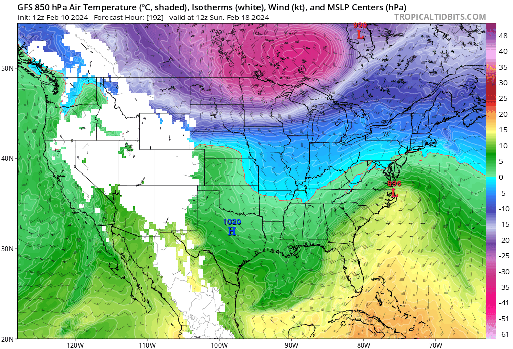
Here is one reason why I have eyes on PD despite the op gfs showing a rainstorm. Feb 13-14 was supposed to be a cutter and was depicted as such up until earlier this week. And we don’t even have cold air anywhere nearby. I think we will see it evolve in our favor once the models work out the northern stream under a greenland blocking regime.
- 2,509 replies
-
- 3
-
-
- weenie fest or weenie roast?
- weenies got roasted
- (and 2 more)
-
If the same happens in a nino, then we can’t simply say it’s a “la nina problem”

- 2,509 replies
-
- 10
-

-
-
- weenie fest or weenie roast?
- weenies got roasted
- (and 2 more)
-
GEFS look good with PD. 850s peak around normal during the event, which is around -3 nw of 95 and -2 for the rest
- 2,509 replies
-
- 8
-
-
- weenie fest or weenie roast?
- weenies got roasted
- (and 2 more)
-
For better or worse, it will change. Stick with the ensembles especially at this range
-
Lots of cold air lurking nearby on that run. I don’t think this will be a complete rainstorm
- 2,509 replies
-
- 6
-
-
- weenie fest or weenie roast?
- weenies got roasted
- (and 2 more)
-
7/8 now then weak 1/2 the rest of the month
-
2024 Valentines Day Who the Hell Knows - Comeback Thread
Terpeast replied to DDweatherman's topic in Mid Atlantic
No worries, we’re good -
Like PSU said 2 months ago… not everyone is going to make it.
- 2,509 replies
-
- 4
-
-
-
- weenie fest or weenie roast?
- weenies got roasted
- (and 2 more)
-
2024 Valentines Day Who the Hell Knows - Comeback Thread
Terpeast replied to DDweatherman's topic in Mid Atlantic
If I think that this is going be north of us, do you not want me to say it? Just… be silent? I’m sorry but that’s not how I roll. If I think it, I’m gonna say it. Just be grateful that I’m not going to repeat it every 5 minutes like some others do -
I’m still not counting out the potential around PD. It’s a bit suppressed for us, but less suppressed than it was a few days ago. These things trend north most of the time, even though there’s a limit how far north they can get with a block in place.
- 2,509 replies
-
- 4
-
-
- weenie fest or weenie roast?
- weenies got roasted
- (and 2 more)
-
Its trended a bit north the last couple of days, though. Less suppression
-
It’s just one run maybe two, and the EPO trend may be incorrectly modeled, but Commodity WG posted this (and I consider them to be credible): https://x.com/commoditywx/status/1756015637673972047?s=46&t=etSZn0BwxaYu-SKkXncW9w Right now I don’t have any confidence in what’s going to happen the rest of this month. None. I’m in wait and see mode now.
- 2,509 replies
-
- 1
-
-
- weenie fest or weenie roast?
- weenies got roasted
- (and 2 more)
-
2024 Valentines Day Who the Hell Knows - Comeback Thread
Terpeast replied to DDweatherman's topic in Mid Atlantic
Yeah, this is a PA/NY/SNE event. Let them have it. They need a morale boost -
That it is. Then again, the ns is all over the place with the gfs. Zero confidence in any solution it puts out beyond 180hrs, except that there will be a ss wave deep south
- 2,509 replies
-
- 1
-
-
- weenie fest or weenie roast?
- weenies got roasted
- (and 2 more)
-
2024 Valentines Day Who the Hell Knows - Comeback Thread
Terpeast replied to DDweatherman's topic in Mid Atlantic
Didn’t the NAM lead the way in the south trend for both Jan storms? Or did I get my wires crossed up? -
I suspect it’s partly because of smoothing between cool downs and warm ups, but with a dynamic storm that runs south of us we’ll get mostly snow. I don’t have much confidence in these rainstorm depictions with such a strong blocking episode coming up, so I guess that’s why most mets aren’t talking about it unless they have a warm bias or are panicking. we could go a couple degrees warmer across the board except when a vort passes south of us, and we’d still snow even (and especially) in late feb early march
- 2,509 replies
-
- 2
-
-
- weenie fest or weenie roast?
- weenies got roasted
- (and 2 more)
-
2024 Valentines Day Who the Hell Knows - Comeback Thread
Terpeast replied to DDweatherman's topic in Mid Atlantic
I don’t think we’ve seen the last of the trends. Still details to be worked out -
If the gfs is correct and other models trend this way, we might have another tracking opportunity sooner than most are expecting. I don’t think any of the models are doing a good job with the ns/ss interactions and just smoothes everything out in the long range. My wag is that there will be an unexpected plot twist in the next 10-14 days. Just hope one breaks in our favor.
- 2,509 replies
-
- 9
-
-
- weenie fest or weenie roast?
- weenies got roasted
- (and 2 more)