Terpeast
-
Posts
5,326 -
Joined
-
Last visited
Content Type
Profiles
Blogs
Forums
American Weather
Media Demo
Store
Gallery
Everything posted by Terpeast
-
2024 Valentines Day Who the Hell Knows - Comeback Thread
Terpeast replied to DDweatherman's topic in Mid Atlantic
They went pretty low. Curious as to what's their high end call is -
2024 Valentines Day Who the Hell Knows - Comeback Thread
Terpeast replied to DDweatherman's topic in Mid Atlantic
Agreed. I think the 12k tends to overestimate snowfall and accumulations in marginal situations. I would think that the higher resolution 3k would capture the lower BL and microclimates better, and if the lower BL is a degree too warm then the 12k can easily miss that. The 3km HRRR on the other hand... -
2024 Valentines Day Who the Hell Knows - Comeback Thread
Terpeast replied to DDweatherman's topic in Mid Atlantic
Just before the commute I think -
2024 Valentines Day Who the Hell Knows - Comeback Thread
Terpeast replied to DDweatherman's topic in Mid Atlantic
I think in this case it comes down to the upper level low track -
2024 Valentines Day Who the Hell Knows - Comeback Thread
Terpeast replied to DDweatherman's topic in Mid Atlantic
3k nam holds onto rain as the ptype for the metros, while 12k is much snowier. It’s going to come down to rates. -
2024 Valentines Day Who the Hell Knows - Comeback Thread
Terpeast replied to DDweatherman's topic in Mid Atlantic
H5 vort track and strength look similar to me on both. Different qpf maps sure -
2024 Valentines Day Who the Hell Knows - Comeback Thread
Terpeast replied to DDweatherman's topic in Mid Atlantic
CAMs were the first to catch on for both Jan events. Can they score a hat trick here? -
2024 Valentines Day Who the Hell Knows - Comeback Thread
Terpeast replied to DDweatherman's topic in Mid Atlantic
Now that is a beatdown (whether it verifies is TBD) -
2024 Valentines Day Who the Hell Knows - Comeback Thread
Terpeast replied to DDweatherman's topic in Mid Atlantic
Interesting how the globals and cams are so far apart on snowfall amounts in this sub less than 24 hours before the event -
2024 Valentines Day Who the Hell Knows - Comeback Thread
Terpeast replied to DDweatherman's topic in Mid Atlantic
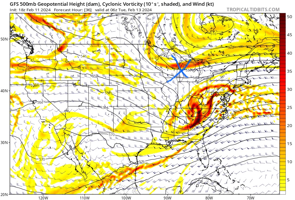
Strong convection in the SE is the reason we are seeing a south trend.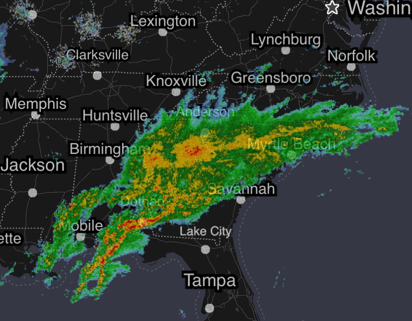
-
2024 Valentines Day Who the Hell Knows - Comeback Thread
Terpeast replied to DDweatherman's topic in Mid Atlantic
Lo and behold, the 12z HRRR. Could see a few hours of snow on the backend, and a dynamic one at that -
2024 Valentines Day Who the Hell Knows - Comeback Thread
Terpeast replied to DDweatherman's topic in Mid Atlantic
Keeping an eye on how the CAMs resolve the convection the SE, which may lead to pulling the storm further south. Going to be an interesting tracking day. -
No idea, and have no confidence in the LR models either. They missed the wintry week in Jan, and underestimated the “relax” period afterward. They were honking the great pattern, and then it fell apart so quickly. Doesn’t mean they’re more correct now, and ironically the GEPS is now the warmest of the three when it’s usually biased coldest. modeling has been a crapshoot this winter is all I can say
- 2,509 replies
-
- 3
-

-
- weenie fest or weenie roast?
- weenies got roasted
- (and 2 more)
-
Models lost the nao basically
- 2,509 replies
-
- 1
-

-
- weenie fest or weenie roast?
- weenies got roasted
- (and 2 more)
-
2024 Valentines Day Who the Hell Knows - Comeback Thread
Terpeast replied to DDweatherman's topic in Mid Atlantic
What’s also changed is the nam and eps closes off the h5 wave, whereas before it remained an open wave. 0z should be interesting -
If I were the HC I’d pull Kelce
-
You aren’t kidding. This is why I’m not calling TOD on this winter yet.
-
I’m waiting until the 18th to call it. If that event fails, and the models are still trending warm all the way into march, then I’m going to start wrapping this thing up and looking at potential winter destinations for next year
-
Yeah, if we had a cold airmass in place, we might have gotten a CAD thump (when’s the last time we had CAD?) before a dry slot during the coastal transfer then a ULL pass with additional snow. This year, the only way it snowed was with a -EPO/-NAO combo. PNA didn’t seem to matter. STJ? Any stj wave by itself was too warm. We needed that EPO to deliver the cold air, and a beast NAO to hold it down.
- 2,509 replies
-
- 1
-
-
- weenie fest or weenie roast?
- weenies got roasted
- (and 2 more)
-
2024 Valentines Day Who the Hell Knows - Comeback Thread
Terpeast replied to DDweatherman's topic in Mid Atlantic
That ns vort has been quietly trending south the last 6-8 runs. Continue that for for another 24 hours, the N&W crew may back into something here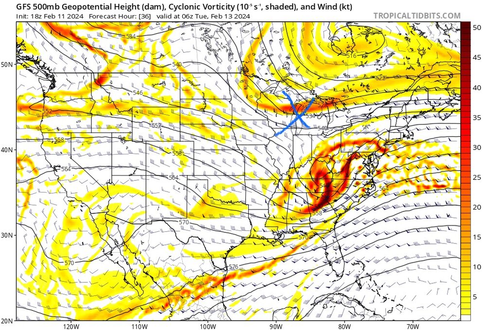
-
I don’t know what the 3rd one was, but that dec event - I’m not sure I agree that its a good example. It was more of a function of timing with cold air’s arrival during the precip event. It morphed from an anafront to a wave along the front. It would have happened the same way 60 years ago vs today, and had that wave been 6 hours slower, we would have gotten a nice 3-6” event across the metros. Jan 7 is the more glaring example, to me. That’s what prompted me to lower my expectations for the rest of the season. Had it been colder, the low would have taken a track 50-100 miles souther than it did, and we’d have gotten 6-12”+
- 2,509 replies
-
- 2
-
-
- weenie fest or weenie roast?
- weenies got roasted
- (and 2 more)
-
Jan 7 is the obvious one. What were the other two?
-
Same, it’s not over yet. (Even though it feels like the fat lady is clearing her throat about now)
- 2,509 replies
-
- 1
-
-
- weenie fest or weenie roast?
- weenies got roasted
- (and 2 more)
-
Yeah, the models are totally lost on handling this pattern change and what comes soon after.
- 2,509 replies
-
- 2
-
-
- weenie fest or weenie roast?
- weenies got roasted
- (and 2 more)
-
Great post. You’d think we’d need a beast NAO block, but the feb 7 run is only marginally better than today’s run. It won’t take much at all to reel this one back in. Definitely keeping an eye.
- 750 replies
-
- 3
-
-
- snow elk
- wooly worm
- (and 1 more)