Terpeast
-
Posts
5,326 -
Joined
-
Last visited
Content Type
Profiles
Blogs
Forums
American Weather
Media Demo
Store
Gallery
Everything posted by Terpeast
-
2024 Valentines Day Who the Hell Knows - Comeback Thread
Terpeast replied to DDweatherman's topic in Mid Atlantic
I’m more than fine with this run. Just living dangerously on the southern edge -
2024 Valentines Day Who the Hell Knows - Comeback Thread
Terpeast replied to DDweatherman's topic in Mid Atlantic
Doesn’t look that much different to me. Precip shield broader, slp position similar, 540 thickness line a tick SE -
2024 Valentines Day Who the Hell Knows - Comeback Thread
Terpeast replied to DDweatherman's topic in Mid Atlantic
That’s what I heard, and its a good sign -
2024 Valentines Day Who the Hell Knows - Comeback Thread
Terpeast replied to DDweatherman's topic in Mid Atlantic
0z hrrr definitely a tick south. About 30 miles -
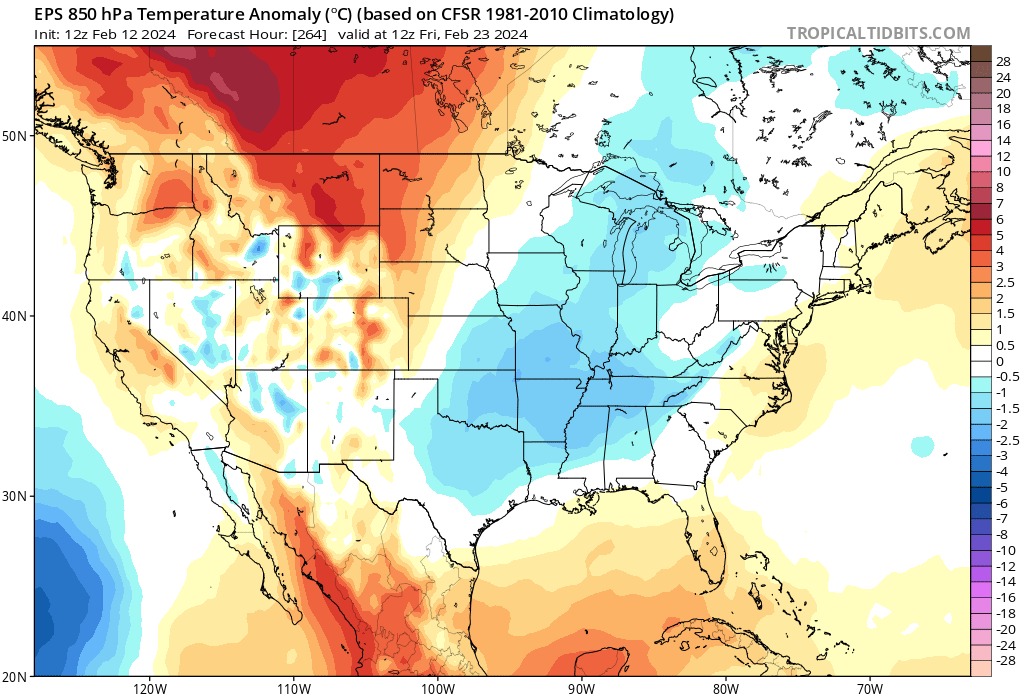
850s right around average (-2 to -3)
- 2,509 replies
-
- 4
-

-

-
- weenie fest or weenie roast?
- weenies got roasted
- (and 2 more)
-
2024 Valentines Day Who the Hell Knows - Comeback Thread
Terpeast replied to DDweatherman's topic in Mid Atlantic
Same. 44.2/43.9 -
I’ve read what he said about the expanded hadley cell, but he said it isn’t due to AGW. So I don’t know what to pin it on other than the west pac warm pool. I’m running out of answers if I’m being frank
- 2,509 replies
-
- 3
-
-
-
- weenie fest or weenie roast?
- weenies got roasted
- (and 2 more)
-
Its because they were expecting a big dog because it looked that way a couple weeks ago, and now that's no longer the case and many are very disappointed and frustrated. I am, too, but I'm not calling the end of winter because there will still be chances after tomorrow.
- 2,509 replies
-
- 4
-
-
- weenie fest or weenie roast?
- weenies got roasted
- (and 2 more)
-
2024 Valentines Day Who the Hell Knows - Comeback Thread
Terpeast replied to DDweatherman's topic in Mid Atlantic
Probably won't verify, but I'm getting a kick of a depiction of 6" from one side of the airport to nada on the other. -
2024 Valentines Day Who the Hell Knows - Comeback Thread
Terpeast replied to DDweatherman's topic in Mid Atlantic
3" 10:1 E Loudoun at 14z and still snowing (20z HRRR) -
2024 Valentines Day Who the Hell Knows - Comeback Thread
Terpeast replied to DDweatherman's topic in Mid Atlantic
Temps - I'm at 47.5/47 atm. Long way to go. -
Yep. He was saying that nat gas futures were indicating a warm winter ahead. I thought that was odd, yet here we are.
- 2,509 replies
-
- 1
-
-
- weenie fest or weenie roast?
- weenies got roasted
- (and 2 more)
-
2024 Valentines Day Who the Hell Knows - Comeback Thread
Terpeast replied to DDweatherman's topic in Mid Atlantic
Seems to be theme of this winter -
2024 Valentines Day Who the Hell Knows - Comeback Thread
Terpeast replied to DDweatherman's topic in Mid Atlantic
Bring it on, what's good for W Loudoun is also good for me even though I'm just a stone's throw across the eastern side of 15 -
2024 Valentines Day Who the Hell Knows - Comeback Thread
Terpeast replied to DDweatherman's topic in Mid Atlantic
"Up to 2 inches" WWA for eastern loudoun. Reasonable call -
2024 Valentines Day Who the Hell Knows - Comeback Thread
Terpeast replied to DDweatherman's topic in Mid Atlantic
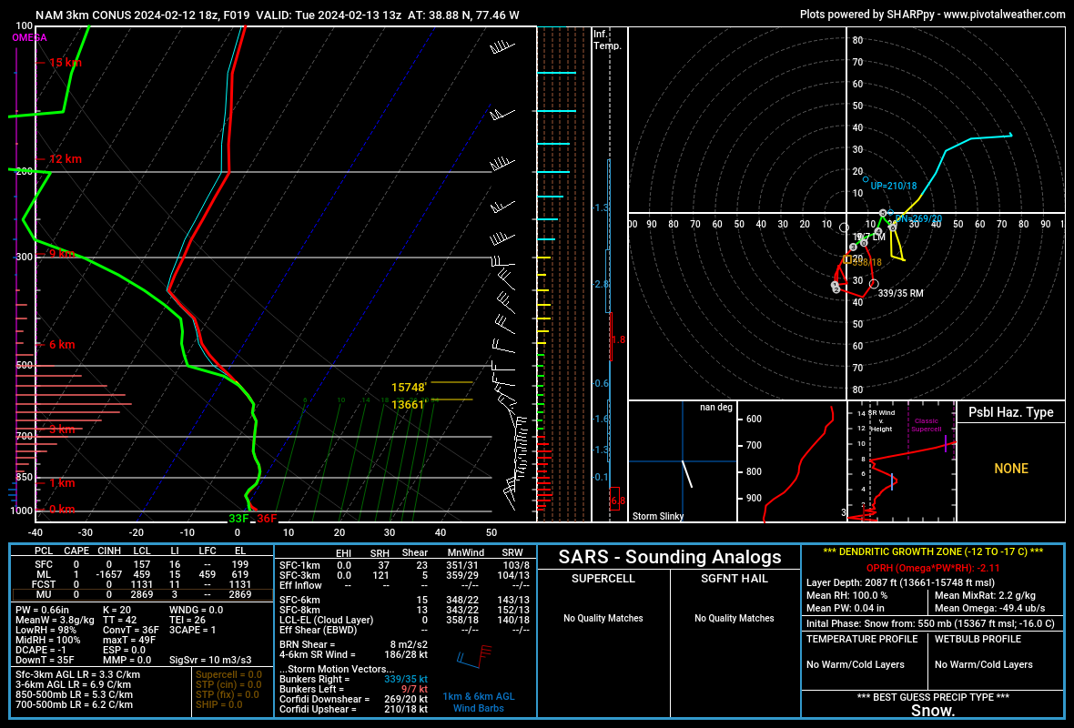
18z 3k NAM IAD sounding right when it flips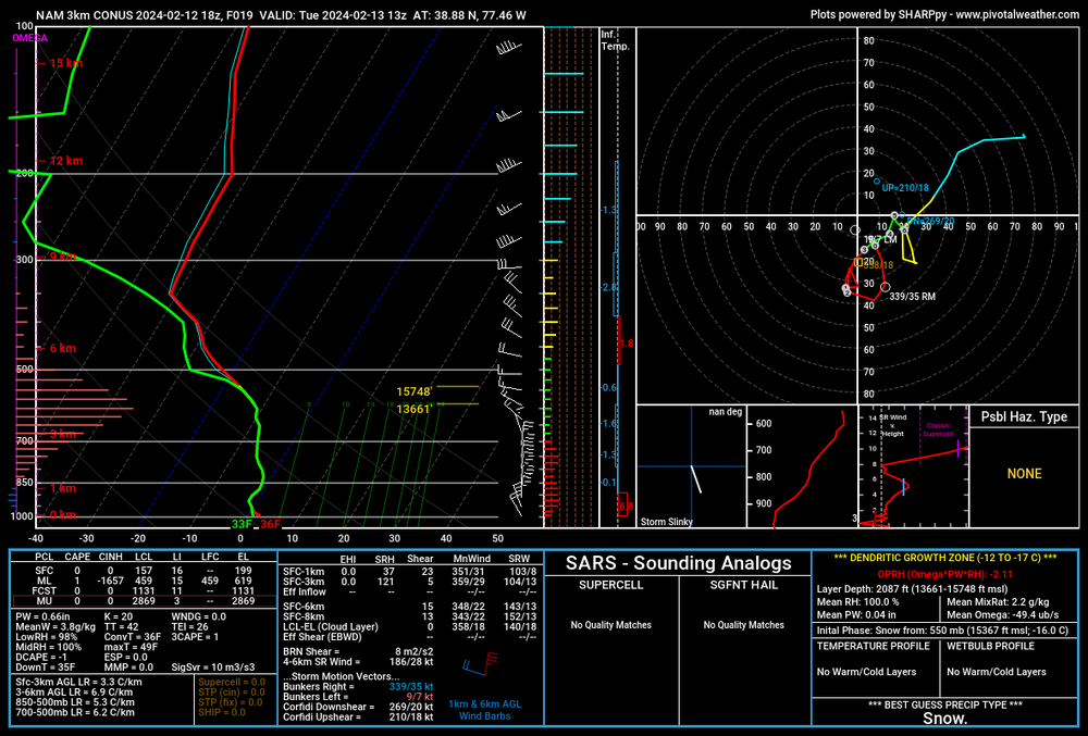
-
2024 Valentines Day Who the Hell Knows - Comeback Thread
Terpeast replied to DDweatherman's topic in Mid Atlantic
At this rate, this will be a EZF-RIC hit (half joking) -
Yeah, maybe we should've listened to Chuck. If you can get past the Chuck-speak and really understand what he's saying, you'll see his uncanny ability to make calls that seemed farfetched and then come true later. And we did get a beast -NAO block in January... it was surprising how quickly it fell apart.
- 2,509 replies
-
- 7
-
-
- weenie fest or weenie roast?
- weenies got roasted
- (and 2 more)
-
2024 Valentines Day Who the Hell Knows - Comeback Thread
Terpeast replied to DDweatherman's topic in Mid Atlantic
Agreed. Even 2-3" would be a steal considering how this system was depicted in the weeks leading up to now -
2024 Valentines Day Who the Hell Knows - Comeback Thread
Terpeast replied to DDweatherman's topic in Mid Atlantic
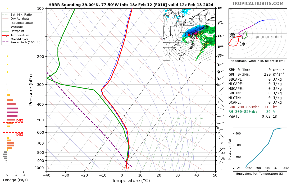
HRRR sounding at IAD for 12z tomorrow
-
2024 Valentines Day Who the Hell Knows - Comeback Thread
Terpeast replied to DDweatherman's topic in Mid Atlantic
I don’t think this is right, but…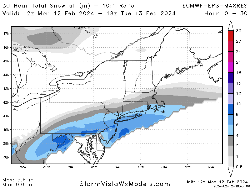
-
2024 Valentines Day Who the Hell Knows - Comeback Thread
Terpeast replied to DDweatherman's topic in Mid Atlantic
Oof, that eps run -
2024 Valentines Day Who the Hell Knows - Comeback Thread
Terpeast replied to DDweatherman's topic in Mid Atlantic
Wouldn’t be surprised to see a WWA in the next tier of counties south of the current WSW -
2024 Valentines Day Who the Hell Knows - Comeback Thread
Terpeast replied to DDweatherman's topic in Mid Atlantic
12z euro shows more snow for the metros than 0z/6z, though that’s not saying much. Just 1” verbatim for mby -
2024 Valentines Day Who the Hell Knows - Comeback Thread
Terpeast replied to DDweatherman's topic in Mid Atlantic
Looks good. Reasonable. I love how the GFS has 10"+ across the river from me, with me getting almost nothing. This thing is gonna come down to rates.