Terpeast
-
Posts
5,326 -
Joined
-
Last visited
Content Type
Profiles
Blogs
Forums
American Weather
Media Demo
Store
Gallery
Everything posted by Terpeast
-
The Weekend Rule? Saturday 2/17 - The Icon Storm
Terpeast replied to DDweatherman's topic in Mid Atlantic
Yeah, sticking with 2-4" for dc/balt, and N/W suburbs will make a run for the high end locally 5". No reason to change my first call despite the north trend (a lot of it is model noise) I-95 and east looks like they'll have temp issues at the onset, but then the rates should overcome that. Then it's only a matter of how long that lasts. N&W will have a longer window of heavy rates with freezing temps allowing for more accumulation I'm at 47 now, but dewpoint is 16 -
The Weekend Rule? Saturday 2/17 - The Icon Storm
Terpeast replied to DDweatherman's topic in Mid Atlantic
That's what my wife said. She still doesn't believe it -
The Weekend Rule? Saturday 2/17 - The Icon Storm
Terpeast replied to DDweatherman's topic in Mid Atlantic
Surprised to see the warning get expanded east to include mby. 4-6" forecast. East side of IAD 2-5". -
The Weekend Rule? Saturday 2/17 - The Icon Storm
Terpeast replied to DDweatherman's topic in Mid Atlantic
Besides there's only 12 hours left. Not a whole lot of time left for big shifts -
The Weekend Rule? Saturday 2/17 - The Icon Storm
Terpeast replied to DDweatherman's topic in Mid Atlantic
Yes, this has trended north, but we're still in the game. If I lived 30 miles south of DC, I'd be sweating it though -
The Weekend Rule? Saturday 2/17 - The Icon Storm
Terpeast replied to DDweatherman's topic in Mid Atlantic
They're probably rolling their eyes at us now (and I don't blame them lol) -
The Weekend Rule? Saturday 2/17 - The Icon Storm
Terpeast replied to DDweatherman's topic in Mid Atlantic
That's my wag. I called for 2-4" dc/balt metros and 4-7" far N&W, and don't see any reason to change that. I'd love to get 5" out of this, though! -
The Weekend Rule? Saturday 2/17 - The Icon Storm
Terpeast replied to DDweatherman's topic in Mid Atlantic
Western loudoun is either/both higher elevation and less populated than eastern loudoun, so it makes sense they hedged with a warning there. It's also a saturday morning, so that's probably why they went with a WWA east loudoun even though they're forecasting for 3-5" locally up to 7" imby. Had it been a weekday, they would have gone with a warning. -
The Weekend Rule? Saturday 2/17 - The Icon Storm
Terpeast replied to DDweatherman's topic in Mid Atlantic
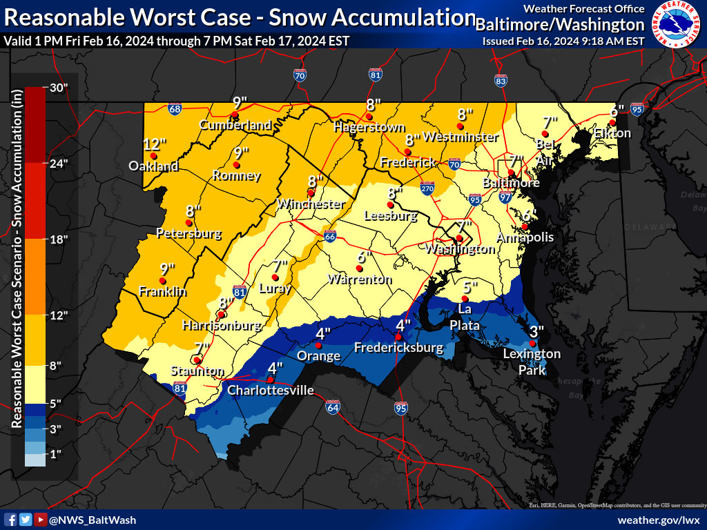
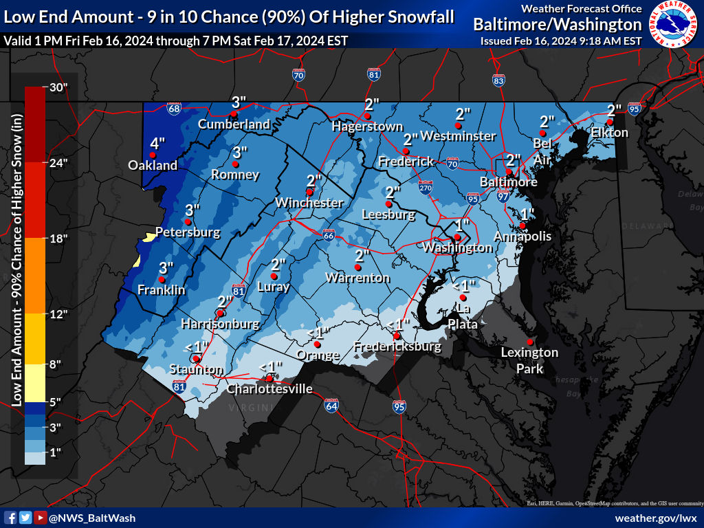
High end potential: Low end floor:

-
The Weekend Rule? Saturday 2/17 - The Icon Storm
Terpeast replied to DDweatherman's topic in Mid Atlantic
It did well for one or both of the Jan events, but a terrible job with the recent one a few days ago -
The Weekend Rule? Saturday 2/17 - The Icon Storm
Terpeast replied to DDweatherman's topic in Mid Atlantic
Probably mount PSU and places up near the m/d line, and someone around the dc metro may eek out 6” -
The Weekend Rule? Saturday 2/17 - The Icon Storm
Terpeast replied to DDweatherman's topic in Mid Atlantic
Technically a stj-enhanced northern stream wave. A good sign for qpf verifying on the high end of forecast -
The Weekend Rule? Saturday 2/17 - The Icon Storm
Terpeast replied to DDweatherman's topic in Mid Atlantic
My thoughts too. I’m at 37/19 -
The Weekend Rule? Saturday 2/17 - The Icon Storm
Terpeast replied to DDweatherman's topic in Mid Atlantic
Temps aren’t the problem north of 66 -
The Weekend Rule? Saturday 2/17 - The Icon Storm
Terpeast replied to DDweatherman's topic in Mid Atlantic
Yeah, it’s pretty much noise. 0z ICON is actually similar to 12z -
The Weekend Rule? Saturday 2/17 - The Icon Storm
Terpeast replied to DDweatherman's topic in Mid Atlantic
Yeah, that would bring the grade on my snowfall outlook from an F to a D -
Interesting take. That may be what it takes to dissipate these marine heat waves. Hopefully we can do that without too much collateral damage.
-
The Weekend Rule? Saturday 2/17 - The Icon Storm
Terpeast replied to DDweatherman's topic in Mid Atlantic
Looks like 3-4" area wide north of 50/66 -
The Weekend Rule? Saturday 2/17 - The Icon Storm
Terpeast replied to DDweatherman's topic in Mid Atlantic
Weird, not sure. Some overlapping going on there.. -
The Weekend Rule? Saturday 2/17 - The Icon Storm
Terpeast replied to DDweatherman's topic in Mid Atlantic
Probably automated -
The Weekend Rule? Saturday 2/17 - The Icon Storm
Terpeast replied to DDweatherman's topic in Mid Atlantic
They’ll probably replace it with a new headline. Not sure why they hoisted a special weather statement in the first place, especially seeing that they hoisted a WSW soon after -
The Weekend Rule? Saturday 2/17 - The Icon Storm
Terpeast replied to DDweatherman's topic in Mid Atlantic
Glad to see the euro hold instead of trending north. Sticking with 2-4” for dc/balt with a little more upside -
The Weekend Rule? Saturday 2/17 - The Icon Storm
Terpeast replied to DDweatherman's topic in Mid Atlantic
Hopefully we may not need to. Ensembles on all models have been zeroing in on our sub and looking more stable. -
The Weekend Rule? Saturday 2/17 - The Icon Storm
Terpeast replied to DDweatherman's topic in Mid Atlantic
Not 100% sure for DC south, even mby. If the 18z euro jumps north from 12z, I’m pulling the fire alarm on this -
The Weekend Rule? Saturday 2/17 - The Icon Storm
Terpeast replied to DDweatherman's topic in Mid Atlantic
Interesting tweet, and digging deeper into the upper level maps, I agree. This gets us more upside in terms of qpf, but the DC metro is dangerously close to missing the best banding with this north trend. I don't think we go 4/4 on last minute south trend this time.