

Terpeast
-
Posts
5,326 -
Joined
-
Last visited
Content Type
Profiles
Blogs
Forums
American Weather
Media Demo
Store
Gallery
Everything posted by Terpeast
-
What Went Wrong in Winter 23-24/Base State/Will It Ever Snow Again??
Terpeast replied to WxUSAF's topic in Mid Atlantic
Either we’ll find out soon once it goes + or the incoming nina will continue the -PDO -
What Went Wrong in Winter 23-24/Base State/Will It Ever Snow Again??
Terpeast replied to WxUSAF's topic in Mid Atlantic
Glimmer of hope out in the Pacific? According to WCS, the PDO has been the highest it’s been in years at only -0.20, pretty close to neutral.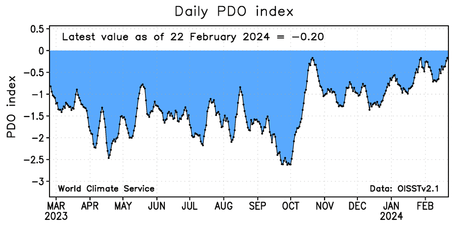
-
Weenie tag me all you want, but I’m just not buying the ACE correlation with eastern winters. If it only works with La Ninas like raindance says, I interpret that as a sign that it doesn’t work at all except mere coincidence. Even some of the classic tele-correlations are not working anymore since about 2018, presumably because of the pacific, which leads me to my next point: Until that marine heat wave off Japan completely dissipates and the Pacific has wholesale changes flipping the PDO to positive, we’re gonna see more of the same in warmer east winters regardless of whether it’s a La Nina or El Nino, or what the Altantic basin decides to do in terms of hurricane activity. Btw @40/70 Benchmark My post was in no way directed at you, I was speaking in general about the ACE correlation. I always read your work and have nothing but respect for what you’ve done.
-
You’ll probably do fine next winter, or even more than fine. But I’m pretty bearish on any wintry prospects east of the apps. Anyone who thinks that high ACE will give us a better winter in the east is likely wishcasting. We need -EPO/-NAO blocking to make that happen, and I think we don’t get as much blocking as we hope. Even less than this year, and definitely less than last year.
-
What Went Wrong in Winter 23-24/Base State/Will It Ever Snow Again??
Terpeast replied to WxUSAF's topic in Mid Atlantic
Well, going by this chart, it's been mostly negative since 1998 with brief pos interruptions. Either the cycles are shortening, or we're going to flip to positive within 2-5 years.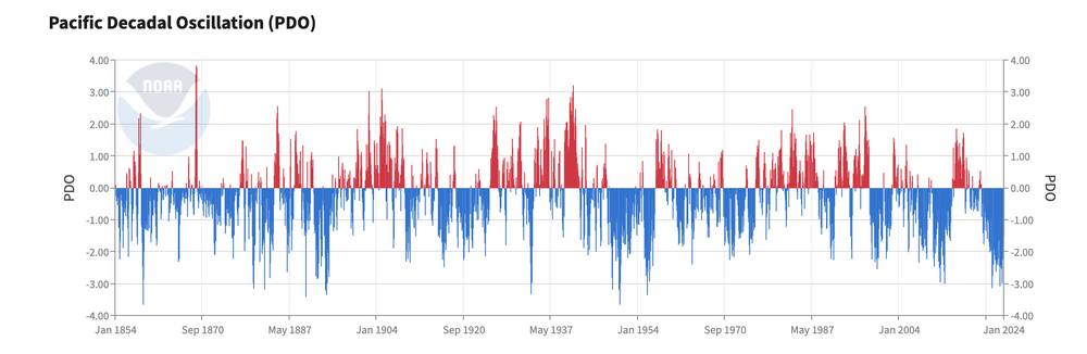
-
What Went Wrong in Winter 23-24/Base State/Will It Ever Snow Again??
Terpeast replied to WxUSAF's topic in Mid Atlantic
Carrying this reply into this thread. The Jan 6-7 event this year is a perfect example of what could have been a 6-12” snowstorm in our area had it not been a couple degrees too warm. A lot of cases we point at may not be clear cut, but this Jan 6-7 one is the most clear cut to me. Unforgivable and inexcusable. After seeing that one fail, I basically threw my snowfall outlook out the window right then and there. -
What Went Wrong in Winter 23-24/Base State/Will It Ever Snow Again??
Terpeast replied to WxUSAF's topic in Mid Atlantic
With a La Nina being almost a given for next winter, the only thing we can realistically root for is the N Pac high to push further poleward into Alaska for a -epo. But with less blocking, good luck getting a -nao. Winter should be a rockin’ out west, though! Start saving up for your trips, folks! -
Late Feb/March Medium/Long Range Discussion
Terpeast replied to WinterWxLuvr's topic in Mid Atlantic
Yeah, there’s a good reason why AFDs never go past 6-7 days -
What Went Wrong in Winter 23-24/Base State/Will It Ever Snow Again??
Terpeast replied to WxUSAF's topic in Mid Atlantic
to be fair, maybe they don’t have any good answers as to why the projected blocks vanished into thin air (literally). All we have is theories and poor LR model performance. My own theory is that the marine heat wave off Japan disrupted the wave train downstream, breaking up any attempt for the aleutian low to form and sustain itself, and also pushing the pac jet northward effectively broke up the blocks. -
Late Feb/March Medium/Long Range Discussion
Terpeast replied to WinterWxLuvr's topic in Mid Atlantic
Big storm? Sure. But won't be surprised at all if we get 3 inches of rain at 38 degrees, and some of us would be thinking, if it only were 1958. Sorry not sorry. -
My house shook too. Severe wx season started early!
-
Late Feb/March Medium/Long Range Discussion
Terpeast replied to WinterWxLuvr's topic in Mid Atlantic
That’s a market bottom signal right there. (new weenie handbook entry) -
Late Feb/March Medium/Long Range Discussion
Terpeast replied to WinterWxLuvr's topic in Mid Atlantic
For sure. With the number of 60-70 degree days. -
What Went Wrong in Winter 23-24/Base State/Will It Ever Snow Again??
Terpeast replied to WxUSAF's topic in Mid Atlantic
I’m not convinced that lower SO2 is the biggest or the only factor, but if it is permanent, then this recent 7-8 year period is our new normal. -
What Went Wrong in Winter 23-24/Base State/Will It Ever Snow Again??
Terpeast replied to WxUSAF's topic in Mid Atlantic
Until the pac flips, I’m going to approach it as nothing will change to the mostly warm winter likely ratters except for a lucky hit like Jan 2022 and mid-Jan this year. In other words, wake me up once we get a +PDO -
What Went Wrong in Winter 23-24/Base State/Will It Ever Snow Again??
Terpeast replied to WxUSAF's topic in Mid Atlantic

-
Late Feb/March Medium/Long Range Discussion
Terpeast replied to WinterWxLuvr's topic in Mid Atlantic
That would be mother nature screwing with us for the fun of it. -
@brooklynwx99 My best guess as I’ve said in another thread is that the pac jet was shoved northward by the marine heat wave off Japan. Physically it makes sense to me. Heights increase above that heat wave, jet goes over instead of under, and breaks up any aleutian low before it even forms.
-
What Went Wrong in Winter 23-24/Base State/Will It Ever Snow Again??
Terpeast replied to WxUSAF's topic in Mid Atlantic
Our best winter week this year was actually due in part to a La Nina-esque pattern with an aleutian ridge that nudged poleward.
-
What Went Wrong in Winter 23-24/Base State/Will It Ever Snow Again??
Terpeast replied to WxUSAF's topic in Mid Atlantic
Where was that? All I got was a flash freeze where I couldn’t even open my car door until I spent 20 minutes melting it with hot water. This Nino winter gave me 12 days worth of sledding and snowman-making days with my daughter. Had the time of our lives, and we didn’t even have to travel to see snow. Cue the Kevin shark tank meme… -
Late Feb/March Medium/Long Range Discussion
Terpeast replied to WinterWxLuvr's topic in Mid Atlantic
I thought so, too, when I did my outlook. It looked as though the pdo was becoming less and less negative, and was sure the nino would win out. -
Late Feb/March Medium/Long Range Discussion
Terpeast replied to WinterWxLuvr's topic in Mid Atlantic
Could the marine heat wave off Japan have anything to do with this? If it’s not MJO4, if it’s not EAMT, then what…? Thinking it through physically, it kind makes sense to me that the marine heat wave could be pushing the extended pac jet poleward so it goes over a la nina instead of under as it would in a canonical nino -
What Went Wrong in Winter 23-24/Base State/Will It Ever Snow Again??
Terpeast replied to WxUSAF's topic in Mid Atlantic
It’s gonna have to snow early and often if we’re going to avoid another ratter. I’m talking between thanksgiving and new year, maybe first week of Jan. Then it’s lights out. -
What Went Wrong in Winter 23-24/Base State/Will It Ever Snow Again??
Terpeast replied to WxUSAF's topic in Mid Atlantic
2022-23 was a modoki nina. This time we won’t have as much blocking as we did last year. As you said… I’m going to work on racking up points to get my family a free flight out west next winter.
-
Late Feb/March Medium/Long Range Discussion
Terpeast replied to WinterWxLuvr's topic in Mid Atlantic
As long as we have a background -pdo state, these canonical nino looks on weeklies shouldn’t be taken seriously. I want to see the pacific flip first, whenever that may be.


