Terpeast
-
Posts
5,326 -
Joined
-
Last visited
Content Type
Profiles
Blogs
Forums
American Weather
Media Demo
Store
Gallery
Everything posted by Terpeast
-
What Went Wrong in Winter 23-24/Base State/Will It Ever Snow Again??
Terpeast replied to WxUSAF's topic in Mid Atlantic
Interesting. I did see someone in the CT forum complaining that the snow under the death band was heavily rimed. He still got 40 inches. Btw, I was in one of the Buffalo LES events back in Dec 2001, one place got over 80" but where I was we "only" got 30-36". Kinda wild to see it go from 3 feet to barely an inch in just 15 minutes driving on I-90 east towards Rochester. The rest of the winter was crap, even up in Rochester. -
What Went Wrong in Winter 23-24/Base State/Will It Ever Snow Again??
Terpeast replied to WxUSAF's topic in Mid Atlantic
That was the year SNE got Nemo. I hope one day I can experience what they did under that >50dbz death band. Or I can just go to the Sierras. Or to Buffalo -
What Went Wrong in Winter 23-24/Base State/Will It Ever Snow Again??
Terpeast replied to WxUSAF's topic in Mid Atlantic
It was basin wide -
Late Feb/March Medium/Long Range Discussion
Terpeast replied to WinterWxLuvr's topic in Mid Atlantic
If this still looks workable inside of 7 days, then I shall track, too -
Late Feb/March Medium/Long Range Discussion
Terpeast replied to WinterWxLuvr's topic in Mid Atlantic
Part of me is rooting for a very strong nina to cool the oceans a tad, and hope for a few weeks of -EPO/-NAO. Just a couple/few weeks, then I’m wrapping it up as a winter. -
Late Feb/March Medium/Long Range Discussion
Terpeast replied to WinterWxLuvr's topic in Mid Atlantic
That’s my thinking. If the MJO is strong in phases 4-6 in October, it would catch my interest. @psuhoffman We haven’t seen a classic sustained PNA+ ridge out west for so long. Every ridge that tried to set up west just kept getting bullied, toppled over us, and brings SER-like warmth to our area. -
Late Feb/March Medium/Long Range Discussion
Terpeast replied to WinterWxLuvr's topic in Mid Atlantic
I guess it depends on which days. Sometimes what he says makes perfect sense and perfectly summarizes what was nagging in my mind and couldn’t put my finger on it. Other times, I’m like
-
Late Feb/March Medium/Long Range Discussion
Terpeast replied to WinterWxLuvr's topic in Mid Atlantic
In case the mods get pissed again about having to move posts - let me provide an easier solution: Simply change the name of this thread. You’re welcome. -
Late Feb/March Medium/Long Range Discussion
Terpeast replied to WinterWxLuvr's topic in Mid Atlantic
That’s where I disagree. Both air AND water are drivers working in tandem, not just air ON water. It’s a two way street. The marine heat wave off Japan is exerting its own influence and a powerful one at that. Zoom in on Japan, you’ll see SSTa off the charts. Take a look, and tell me that isn’t having any effect on the atmospheric pattern.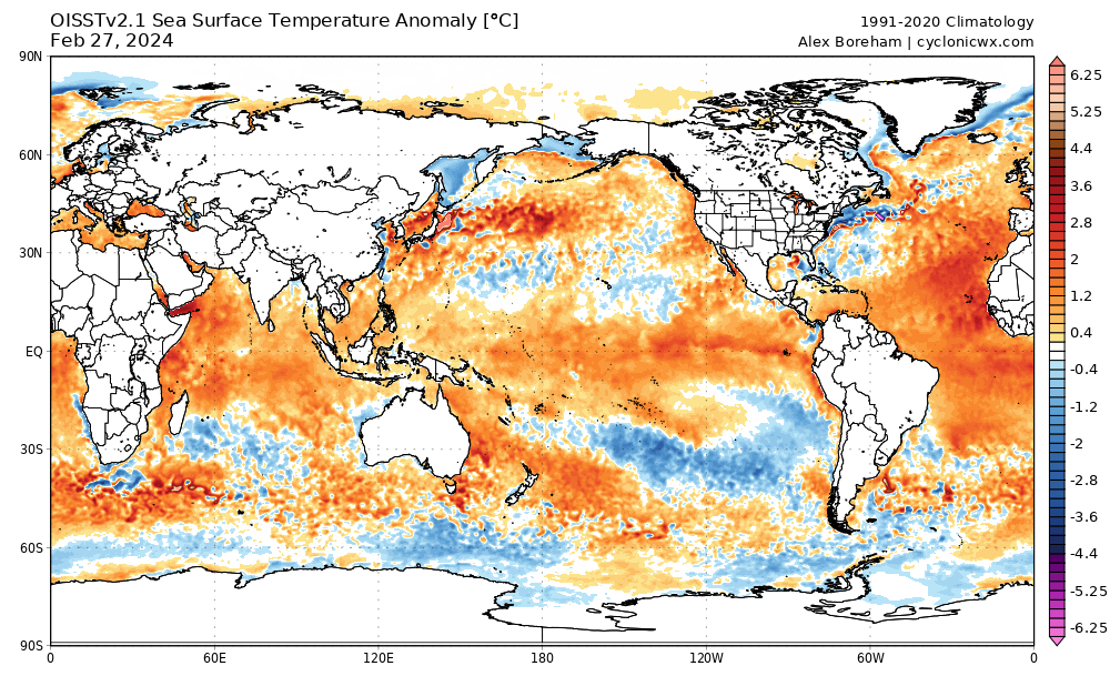
-
Late Feb/March Medium/Long Range Discussion
Terpeast replied to WinterWxLuvr's topic in Mid Atlantic
I don’t think the extreme -pdo is permanent either, but it’s quite the hole to dig out of. Not even a borderline super nino could get us out of that, although it got close but then it collapsed in Feb. We at least did get two SECS in Jan and a minor event in Feb, and that’s got to count for something within a 72-73 analog in a warmer world. -
Late Feb/March Medium/Long Range Discussion
Terpeast replied to WinterWxLuvr's topic in Mid Atlantic
One thing I’ll say about these LR charts is this. As long as we’re in a -PDO driven by the marine heat waves in the west pacific and off Japan, I would place no faith in LR charts no matter how good they may look. -
Late Feb/March Medium/Long Range Discussion
Terpeast replied to WinterWxLuvr's topic in Mid Atlantic
I'm just the messenger. Look at where Fukushima is on Google Maps, and then compare that location against the warmest SST anomalies on those two CFS forecast maps @GaWx above. -
Late Feb/March Medium/Long Range Discussion
Terpeast replied to WinterWxLuvr's topic in Mid Atlantic
The hottest SSTa of the marine heat wave is almost exactly where, and downstream of, Fukushima, the site from where they are dumping radioactive water. I haven’t come across any research that this is the cause, but I can’t seriously believe that this is a mere coincidence. -
Yeah, and it has to be on the pacific side. I don’t see how atlantic activity would help. Great article. The last line in this paper opens the possibility for a reversal to an el nino background state once the aerosol effect on enso runs its course (if they’re correct about the cause)
-
Late Feb/March Medium/Long Range Discussion
Terpeast replied to WinterWxLuvr's topic in Mid Atlantic
Good question. They aren’t so different in certain domains like ENSO, IO, MC, and even off the US West coast. But in the extra-tropical west pacific they could not be more different. I think part of the answer is that the marine heat wave off Japan is an extreme climatological event that is neither reproducible or predictable by any climate model, let alone any seasonal forecasting models. Find a way to dissipate that marine heat wave, then maybe we have a chance at colder winters again. -
Late Feb/March Medium/Long Range Discussion
Terpeast replied to WinterWxLuvr's topic in Mid Atlantic
Weenie post warning: Well if we go with a 2010-11 analog, maybe that boxing day redux would be a hit for our forum instead of a heartbreaking miss. -
What Went Wrong in Winter 23-24/Base State/Will It Ever Snow Again??
Terpeast replied to WxUSAF's topic in Mid Atlantic
I looked 3 pages back to now, and found nothing of substance from your posts except “don’t trust day 15 models” Maybe I missed it, or maybe I didn’t dig deep enough. But if you really want to foster change in this forum in terms of how to do seasonal forecasting, don’t send us digging for that information. We don’t have time for that. Make a standalone thread and link to it instead. -
Late Feb/March Medium/Long Range Discussion
Terpeast replied to WinterWxLuvr's topic in Mid Atlantic
Not good enough for me to get interested. Looks like an elevation event -
What Went Wrong in Winter 23-24/Base State/Will It Ever Snow Again??
Terpeast replied to WxUSAF's topic in Mid Atlantic
What were they? -
Predominately La Nina pattern
-
Low of 21
-
Don’t see anything outside. But it’s cold. The kind of cold that chills you to the bone
-
You could be right, but its hard to bet against the current pacific state and warm mjo phase dominance since 2018. Maybe high ACE will change that, but I’ll believe it when I see it. Otherwise, persistence is the winning play (and that’s coming from someone who went against persistence for the 23-24 winter outlook)
-
Let’s see what the west pacific does as far as typhoon season goes. Maybe it will help dent that marine heat wave off Japan.
-
What Went Wrong in Winter 23-24/Base State/Will It Ever Snow Again??
Terpeast replied to WxUSAF's topic in Mid Atlantic
How confident am I? Low-medium. Just because we have a +pdo doesn’t automatically mean we get colder winters. I see plenty of warm winters that happened during a +pdo. But a +pdo makes it easier to sustain a more classic +pna ridge instead of getting bullied over by constant western troughing.