Terpeast
-
Posts
5,326 -
Joined
-
Last visited
Content Type
Profiles
Blogs
Forums
American Weather
Media Demo
Store
Gallery
Everything posted by Terpeast
-
Good points. I would think that if we’re going be on the cool ENSO side of neutral, 2016-17 would be a better analog match than 2014-15 since the latter was in a +pdo regime whereas we’ve been in -pdo since the 2015-16 super nino. Despite the +1.5 rise in the PDO, still think we’ll stay negative through this year and next unless it actually breaks through into positive territory, which is remotely possible if that warm blob migrates eastward to the NA west coast.
-
Honestly, out of all the neutral winters since 1999, most were pretty bad except for 2013-14. The worst ones was when we had a -pdo background state. So for the MA, I don’t think it’ll make much difference whether cold neutral or La Nina. It’ll be a warm -pdo winter either way.
-
Crazy to see that it barely missed me to the north. It was pretty quiet down here.
-
And for the west Pac to cool, too. But no sign of that happening yet.
-
I still wonder if the discharge of radioactive water off Japan has played, or is playing a role, in this marine heat wave. Perhaps a small role, and its more likely that changes in atmospheric circulations thanks to the WP warm pool is playing a larger role. But I don’t really know for sure. Also notice the marine heat wave seems to be spreading eastward with its extent all the way south of the GOA. One way we could see wholesale pacific changes is if that heat wave spreads all the way to the western coast of NA, while it abates off Japan and NW of Hawaii. Then we’d circle back to a 2013-15-like pattern. But that remains to be seen whether it happens, if ever. And if it does, it could take a few years.
-
100% And we need wholesale changes across the entire basin to make it favorable.
-
Report: Another Year of Record Heat for the Oceans
Terpeast replied to donsutherland1's topic in Climate Change
I know your post is focused on KW (for good reason, huge 2 day jump) but look at the entire Atlantic. It’s effin boiling! I cannot look at this map without being alarmed for our futures, not to mention our local snowfall prospects. -
Low of 47.5
-
Such a broad area of warm ssta across 90% of the north pacific makes me suspect that the global circulation cells are expanding northward, resulting in a more northward shift in the jet stream. If this keeps up through winter, we’ll likely see the jet stream blast warm pac air across NA, except it won’t be going underneath as in a nino… but rather over the top. Scary to think about potential temp departures come winter. In case I wasn't black pilled about this coming winter, I am now.
-
Seems to be the opposite of last year when I was constantly getting missed and split. Now it seems to hit here with a daily downpour.
-
Second round was windier than the first, heavier rain. Last year I didn’t get trained on like this. Nice event today
-
Now this is getting interesting. More wind, coming down in sheets. Vsby down to 1/4-1/8 mile. But no hail, no damaging wind Edit: dying off now. A good garden wetter. Seen a lot worse.
- 1,696 replies
-
- 2
-

-
- severe
- thunderstorms
- (and 5 more)
-
Nothing more than a garden variety downpour. Minimal wind. So far
- 1,696 replies
-
- 1
-
-
- severe
- thunderstorms
- (and 5 more)
-
Showers from the incoming cell have commenced. Still a wait and see
-
Looks like a cell popping up to the west/WSW of me. We shall see if it holds and what path it takes
- 1,696 replies
-
- 1
-
-
- severe
- thunderstorms
- (and 5 more)
-
Cell passed right over my head. Awesome pouring rain and quite a bit of wind, not quite severe but pretty strong. Don’t have to water the garden for a while.
- 1,696 replies
-
- 4
-
-
- severe
- thunderstorms
- (and 5 more)
-
Just went out for a walk. It’s @87storms’s kind of day out there. Enjoy it!
-
I take no joy in saying this, but I agree with this assessment.
-
Extended summer stormlover74 future snow hole banter thread 23
Terpeast replied to BxEngine's topic in New York City Metro
TT map for comparison (yes, it’s apples vs oranges) I mean, I don’t hate this map. With a cold source nearby, it could be workable. But CFS seems to be on its own, and it’s going to change 1000 times (probably correcting warmer in the last minute)
-
Extended summer stormlover74 future snow hole banter thread 23
Terpeast replied to BxEngine's topic in New York City Metro
By the daily WCS graph, it’s obvious that the strong nino made a dent in the -PDO, but nowhere enough to flip it positive. With waning nino influence, the PDO is right back as negative as it has been prior to the nino. It’s going to be a long time before the PDO goes positive, and I don’t know anymore what it will take to drive that. -
Worth noting that the magnitude of warm anomalies, however short-lived they may be, have been becoming more extreme and are skewing most months AN. If we have a month with 3 weeks of -2 departures, then 1 week of +15, that month is going to end up at least +3 AN or even higher. (You can play with the math and see how it works out) For example, remember that 80 degree day in this January? Take that day away, and Jan 2024 actually ends up just around normal temp wise.
-
Checked ouside at 3:30 am, didn’t see anything. One more chance tonight
-
Sunny out, hoping to catch curtain sightings tonight at around 9-11 pm before I go to bed
-

-
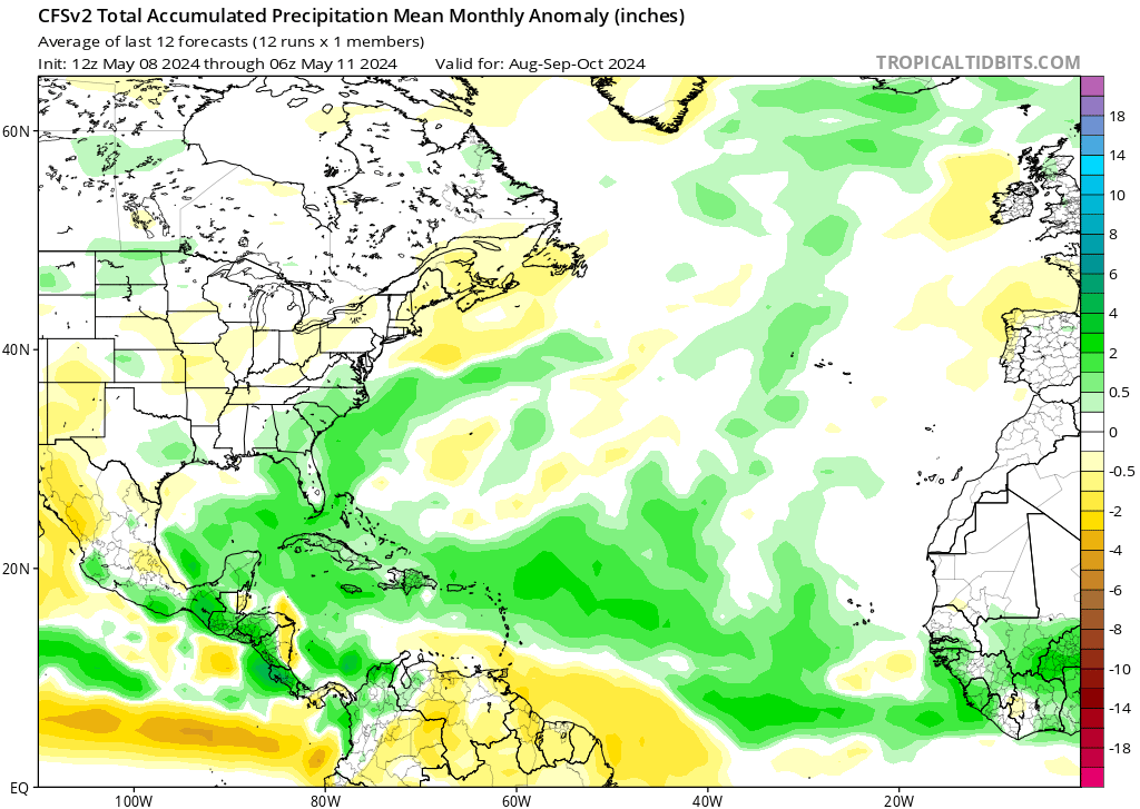
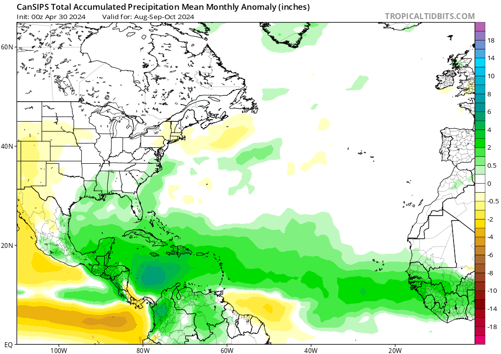
While we’re looking far ahead, CFS is projecting a crazy active tropics. I hope folks from lesser antilles up through VA beach are prepared to board up or have evac plans. If I lived in Florida, I’d be packing a Go bag right about now. CanSips - YIKES