

Terpeast
-
Posts
5,326 -
Joined
-
Last visited
Content Type
Profiles
Blogs
Forums
American Weather
Media Demo
Store
Gallery
Everything posted by Terpeast
-
Thanks for sharing. I agree with the general idea of a mild east and cold snowy west. Also with the torch Feb. My main hope is that January will be closer to average temp wise, which gives us more chances for snow before the Feb shutout. I’m in northern VA.
-
Congratulations Bob! I’m sure it’s a relief. Will be good to have you back this winter. Unfortunately it’s looking real ugly. All factors point to a warm and snowless winter in the MA. Then again, many factors pointed to a snowy winter last year, and we know what happened then… so idk.
-
If the reason behind quiet activity is that the ITCZ is too far north, I wonder if we’ll see a delayed but active period when the ITCZ starts moving back south. But by then it may be too late for MDR genesis
-
I don’t have a twitter account either. Well I had one, but deleted it.
-
Interesting you say that. Last year I did a quantitative analysis on how much CC has impacted our snowfall thus far, and found it to be roughly 16% using two different methods arriving at basically the same answer. But we haven’t seen a merely 16% reduction the last few years - its been way more than that. Either we’re still underestimating the effects of CC on snowfall, or we’re in an awful pattern - which is the point you seem to be making. The big question is whether this awful pattern as of late is being driven by CC itself.
-
Good post, and I agree after checking the new run. I’m a little more pessimistic than you after seeing how dry the 3-month average over DJF is currently depicted to be. But the saving grace is that Canada may not be torched this time like last year, and all it takes is a little well-timed cold push SE…
-
Just a brief shower. Fell apart pretty quick once it crossed over rt 15
-
Thanks for the laugh! Do you have some sort of beef with Boston, though? I’m genuinely curious.
-
Some people in the ENSO thread have been saying that this could be a version 2.0 of the 22-23 winter. Analog looks good, but I think there may be even less blocking this time than that winter unless the tropics start acting up soon. I’m trying to find paths to a decent winter, and aside from the EPO domain, I’m not seeing much.
-
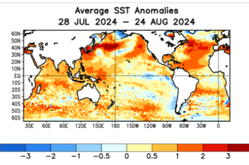
While I think we’ll see more of the same this winter, a potential wild card is that ssts off the west coast have been warming the last 4 weeks. Still have that marine hear wave off Japan and SW of the aleutians, so that’s supportive of a north pacific high on a seasonal scale. But I wonder if we’ll see a bit more -EPO blocking. Like last January, that’s our path to a serviceable albeit below climo winter. But if those waters cool back down in the fall while the Japan marine heat wave persists, I don’t see a way out of another warm and snowless winter unless a short-term fluke happens.
-
2.15" yesterday, 5.84" MTD
-
2.07” and still raining
-
Cell over me just wouldn’t quit. 1.55” and counting
-
95, HI 105
-
Most likely short term, but I think we will see a few deviations away from the nina base state going forward. Those cannot be predicted on a seasonal time scale, though
-
While the upcoming winter looks ugly on a seasonal time scale, I think it's interesting that we have had one significant BN period in the east this month and another one coming in early September. If this is a sign of things to come, 2 maybe 3 periods of significant cold should be in play in an otherwise warm winter. Kind of like last year.
-
The qbo and solar connection to our weather has always looked very weak to me. Until I dive into the data and run my own analyses, I’m open to the possibility of it being not as clear cut as you make it out to be.
-
This is really interesting… it seems for a solar max, we would prefer a westerly QBO based on that map. What was the source of this map, and what data did they use? I want to verify this myself. If you can’t get the source, no worries - I can try to use publicly available data from NOAA.
-
WeatherBell CFS maps are wrong. Apparently it has algorithm issues. @GaWx has been harping on this for months.
-
2009-10 was a neutral PDO on average after a long duration -PDO, fwiw
-
51 for the low again
-
Impressive, considering that it’s been 26 years since the last time this happened
-
51 so far
-
Forecast low for mby (between IAD and JYO) is 49. It will be interesting if that actually happens. Last time we got sub-50 in August was Aug 20, 1998 when IAD dropped to 47
-
Same. Low of 52.9


