

Terpeast
-
Posts
5,326 -
Joined
-
Last visited
Content Type
Profiles
Blogs
Forums
American Weather
Media Demo
Store
Gallery
Everything posted by Terpeast
-
After a bunch of traces, here’s my first report on the board: 12/24: 0.1” snow/ice mix
-
Logging my first 0.1” in the reporting thread
-
Driveways and sidewalks are white. Probably a sheet of ice
-
Haven’t seen any roads treated here. If the nam is right, it’s gonna be bad
-
January: Medium/ Long Range: May the Force be with Us....
Terpeast replied to Weather Will's topic in Mid Atlantic
That's my take, too. I think we'll ultimately see a compromise between the GEFS and EPS/GEPS. Initially, cold moves down west, then a cutter or two pulls the cold east, and by the time we have a trackable threat it might be 1/5-1/7 or soon after (as opposed to 1/4 like we were thinking yesterday or the day before). Also, I'm not sure how durable this upcoming cold period will be. It's been the case for the last several years that we get mostly short-lived cold periods of a week to 10 days each. However, we still should get a trackable threat or two in that cold period just because it's January. -
January: Medium/ Long Range: May the Force be with Us....
Terpeast replied to Weather Will's topic in Mid Atlantic
GEPS is more in EPS camp than GEFS fyi -
January: Medium/ Long Range: May the Force be with Us....
Terpeast replied to Weather Will's topic in Mid Atlantic
Still in wait and see mode. GEFS as depicted will be a cutter on Jan 3, and then *maybe* a follow up wave that slides south of us similar to Jan 2022. Not the big dog we’re looking for, but it still leaves a path to modest success here. -
January: Medium/ Long Range: May the Force be with Us....
Terpeast replied to Weather Will's topic in Mid Atlantic
Since we had such a fast PDO rise, I’d say we’ve had a +PDO atmospheric pattern and it’s taking time to make an imprint on the SSTs. But it’s still an uphill battle that becomes less and less the longer we hold this pattern. -
January: Medium/ Long Range: May the Force be with Us....
Terpeast replied to Weather Will's topic in Mid Atlantic
Now we can’t use the extremely negative PDO as an “excuse”.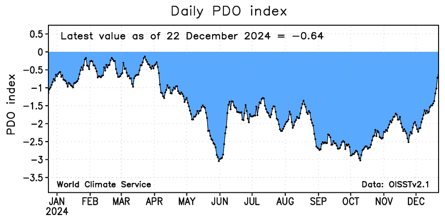
-
13.8. Close enough to forecast
-
19.4 now.
-
January: Medium/ Long Range: May the Force be with Us....
Terpeast replied to Weather Will's topic in Mid Atlantic
If you thought 18z gfs op was a disaster, look at the 18z ensembles. It is even better than 12z. -
Currently 22.6. Forecast low is 13.
-
January: Medium/ Long Range: May the Force be with Us....
Terpeast replied to Weather Will's topic in Mid Atlantic
There's a reason op models are better limited to 168 hours, and then only ensembles after that. All we can take away is that the range of possibilities include a miss to the south, a HECS, and a cutter rainer. Or cold and dry. -
January: Medium/ Long Range: May the Force be with Us....
Terpeast replied to Weather Will's topic in Mid Atlantic
FWIW, despite the flak it gets these days, euro has been the best model this fall in terms of verification scores particularly the ensembles. Not saying the 12z op is correct about the HECS, but it’s a good sign that it’s even showing it as one possibility among a wide range of possibilities. We didn’t even see that last Feb before the good H5 looks collapsed. -
High of 32, falling back to 31
-
The temp gradient between the northern third of this sub, the middle third, and the southern third must have been substantial. Lots of lows in the teens just to the north and mostly 20s down here.
-
January: Medium/ Long Range: May the Force be with Us....
Terpeast replied to Weather Will's topic in Mid Atlantic
The 3rd is 14 days away, discrete threats aren’t going to pop up on in agreement across models with that much lead time. -
23.9
-
January: Medium/ Long Range: May the Force be with Us....
Terpeast replied to Weather Will's topic in Mid Atlantic
Agreed. It’s also a good sign that things are moving forward in time and the progged cold period is at least holding in length or even expanding. Still can get rug pulled a la Feb 2024, and there are no individual threats that are trackable at the moment, so it’s prudent to be cautious. -
January: Medium/ Long Range: May the Force be with Us....
Terpeast replied to Weather Will's topic in Mid Atlantic
MJO rmm forecasts seem to be trending away from an immediate reload in 4, extending time outside of the warm phases to about 3 weeks instead of 2. I’ll check the hollmover charts later, too -
Flurries in ashburn
-
January: Medium/ Long Range: May the Force be with Us....
Terpeast replied to Weather Will's topic in Mid Atlantic
PDO is now “only” -1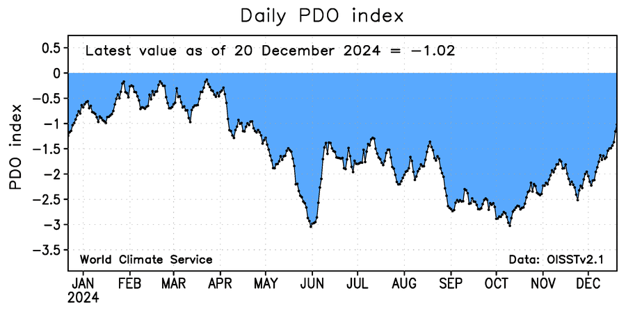
-
Just was at the Leesburg farmer market and it was cold. Windy. Saw clouds with snow falling to the south and west.


